
APPLYING SPATIAL INFORMATION TO SUPPORT POVERTY ALLEVIATION BASED ON ECOLOGICAL LANDSCAPE CHARACTERISTICS: A CASE STUDY OF YASOTHON PROVINCE
Article Sidebar
Main Article Content
Abstract
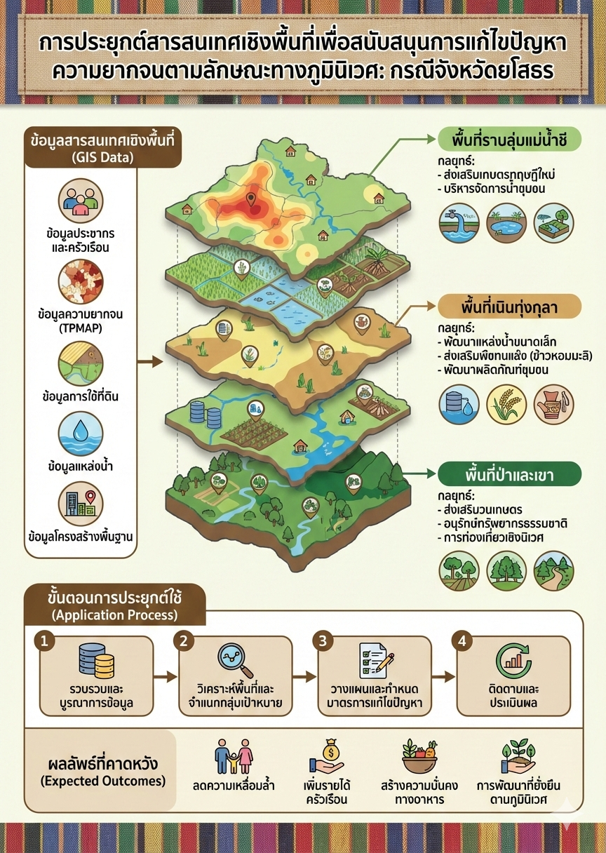
The objectives of this study were to apply spatial information to classify and delineate ecological characteristics, and to group poor households based on spatial contexts and compare them with ecological characteristics to support the design of poverty reduction strategies in Yasothon Province. The study utilized a database of 5,041 poor households. A mixed-methods research approach was employed to integrate quantitative and qualitative data, including the participatory definition of geo-ecological characteristics, the delineation of boundaries using Geographic Information Systems (GIS), the categorization of poor households, and the analysis
of their distribution across the province’s geo-ecological landscapes using the Identity Analysis overlay technique. The results revealed that Yasothon Province could be classified into five ecological types of Phu (uplands), Khok (mounds), Thung (lowland fields), Tham (floodplains), and Mueang (urban areas) which were visualized into maps. The impoverished households were categorized into four groups based on their spatial context of struggling, difficult, manageable, and secure. The spatial analysis comparing the distribution of poor households with the eco-landscape types indicated that the majority of poor households (38.05% of all poor households) resided in the Thung (lowland fields) eco-landscape. However, when analyzing the density of poor households per eco-landscape area, it was found that the Mueang (urban areas) eco-landscape had the highest density, with 4.11 poor households per square kilometer. These variations among eco-landscapes indicated that physical characteristics significantly influenced poverty conditions, particularly in relation to livelihoods and occupations that differed across each eco-landscape type. This study demonstrated the vital role of spatial information systems as tools for defining ecological boundaries, managing physical data, and analyzing the spatial distribution of poor households. The findings could be beneficial in supporting future policy design and decision-making for poverty alleviation and development, enabling relevant agencies to formulate targeted and effective interventions that align with the specific contexts of each ecosystem.
Downloads
Article Details

This work is licensed under a Creative Commons Attribution-NonCommercial-NoDerivatives 4.0 International License.
References
ก้องภพ ชาอามาตย์, ครรชิต สิงห์สุข, อาจศึก มามีกุล, กิตติวัฒน์ จีบแก้ว, และศักดิ์ดา แสนสุพรรณ. (2564). รูปแบบบริหารจัดการน้ำบนภูมินิเวศ โคก ราบ ลุ่ม สำหรับกลุ่มปลูกข้าวอินทรีย์ ตำบลนางัว อำเภอนาหว้า จังหวัดนครพนม. สถาบันวิจัยและพัฒนา มหาวิทยาลัยราชภัฏสกลนคร.
จินตนา อมรสงวนสิน. (2550). ระบบสารสนเทศภูมิศาสตร์เพื่อการพัฒนาอย่างยั่งยืน [GIS for sustainable development]. วารสารการจัดการสิ่งแวดล้อมและความยั่งยืน, 3(2), 220-252. https://so02.tci-thaijo.org/index.php/JEM/article/view/31993.
นำชัย กฤษณาสกุล, ศิริศักดิ์ เอื้อสามาลย์, มนตรี หิตายะ, วสันต์ สุวรรณ์เนตร, และทนงศักดิ์ สายชารี. (2564). การวิจัยเพื่อพัฒนาพื้นที่เพื่อแก้ไขปัญหาความยากจนแบบเบ็ดเสร็จและแม่นยำในพื้นที่จังหวัดยโสธร. สถาบันวิทยาลัยชุมชน.
มนัส สุวรรณ. (2549). ชนบทกับปัญหาความยากจน: มุมมองเชิงนิเวศวิทยามนุษย์. วารสารราชบัณฑิตยสถาน, 31(4), 1137-1149.
แมน ปุโรทกานนท์. (2566). แนวคิดและงานวิจัยเชิงปฏิบัติการแก้ไขปัญหา ความยากจนบนฐานทุนดำรงชีพและศักยภาพ. ใน กิตติ สัจจาวัฒนา (บก.) สู้ชนะความจน บนฐานพลังความรู้ พลังภาค (น.68-83). หน่วยบริหารและจัดการทุนด้านการพัฒนาระดับพื้นที่ (บพท.).
วรรโณบล ควรอาจ และผกามาศ ถิ่นพังงา. (ม.ป.ป.). กระบวนการกลายเป็นเมืองในประเทศไทย. สถาบันสิ่งแวดล้อมไทย.
สำนักงานพัฒนาเทคโนโลยีอวกาศและภูมิสารสนเทศ (องค์การมหาชน). (2552). ตำราเทคโนโลยีอวกาศและภูมิสารสนเทศศาสตร์. อมรินทร์พริ้นติ้งแอนด์พับลิชชิ่ง.
สำนักงานสภาพัฒนาการเศรษฐกิจและสังคมแห่งชาติ. (2562). ดัชนีความก้าวหน้าของคนประจำปี 2562. สำนักงานฯ.
Chambers, R., & Conway, G. (1992). Sustainable rural livelihoods: Practical concepts for the 21st century. IDS Discussion Paper 296.
Hemwan, P. (2015). An appropriate guideline for participatory GIS: A result from the experience of joint management of protected area project in Thailand. Applied Environmental Research, 37(2), 17-31. https://doi.org/10.35762/AER.2015.37.2.2
Scotta, G., & Rajabifard, A. (2017). Sustainable development and geospatial information: A strategic framework for integrating a global policy agenda into national geospatial capabilities. Geo-spatial information science, 20(2), 59–76. https://doi.org/10.1080/10095020.2017.1325594
Suich, H., Howe, C., & Mace, G. (2015). Ecosystem services and poverty alleviation: A review of the empirical links. Ecosystem Services, 12(5), 137-147. https://doi.org/10.1016/j.ecoser.2015.02.005
