Analysis of areas at risk of illegal logging of rosewood and padauk wood in Tham Pha Thi National Park, Lampang Province
Keywords:
Illegal logging, Rosewood, Padauk wood, Tham Pha Tai National ParkAbstract
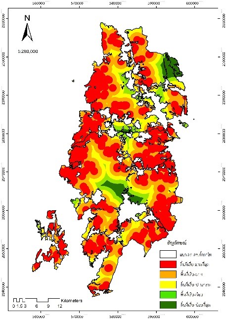
The analysis of the area at risk of illegal logging of Rosewood and Padauk wood in Tham Pha Thai National Park has utilized geospatial information data related to eight factors. These factors include the distribution of valuable wood, distance from the locations of Rosewood and Padauk wood case, distance from road, distance from village, distance from the National Park Protection Unit, distance from water body, slope, and Normalized difference vegetation index (NDVI). The study's methodology involved calculating the potential vulnerability scoring and weighting factors determined by experts. Additionally, a data overlay technique was utilized to identify areas at high risk of illegal cutting of rosewood. Based on the study, it was found that there were five levels of risky areas, including the riskiest area of 199.72 square kilometers, very high-risk area: 336.18 square kilometers, medium-risk area: 337.98 square kilometers, low-risk area has an area of 227.13 square kilometers, and least-risky area has an area of 113.87 square kilometers. The areas of riskiest and very high-risk are found around the edge of the park. The findings of this study can serve as a database for planning and implementing strategies the prevention and suppression of illegal rosewood in the area.
References
กรมอุทยานแห่งชาติ สัตว์ป่า และพันธุ์พืช. (มปป.). แนวทางการวิเคราะห์พื้นที่เสี่ยงต่อภัยคุกคามการลักลอบตัดไม้ในพื้นที่อุทยานแห่งชาติ. มปท.
ชัยยงค์ บัวบาน และคณะ. (2560). โครงการศึกษาการประยุกต์ใช้ระบบสารสนเทศภูมิศาสตร์เพื่อกำหนดพื้นที่เสี่ยงต่อการบุกรุกตัดไม้พะยูงในพื้นที่อุทยานแห่งชาติเขาใหญ่. ศูนย์วิจัยและพัฒนานวัตกรรมอุทยานแห่งชาติ จังหวัดนครราชสีมา กรมอุทยานแห่งชาติ สัตว์ป่า และพันธุ์พืช. กรุงเทพมหานคร.
ทิพย์กมล สนสับ วันชัย อรุณประภารัตน์ และนันทชัย พงศ์พัฒนานุรักษ์. (2561). การกำหนดพื้นที่เสี่ยงต่อการบุกรุกของป่าต้นน้ำที่อุทยานแห่งชาติดอยภูคา จังหวัดน่าน. วารสารวนศาสตร์, 37(2), 60-70.
ปิยมาศ วังคีรี, ลัดดาวรรณ เหรียญตระกูล และ วันชัย อรุณประภารัตน์. (2564). การประยุกต์ระบบสารสนเทศภูมิศาสตร์ในการวิเคราะห์พื้นที่เสี่ยงต่อการบุกรุกบริเวณเขตรักษาพันธุ์สัตว์ป่าภูค้อ–ภูกระแต จังหวัดเลย. วารสารวนศาสตร์ไทย, 40(1), 34-49.
ลัดดาวรรณ เหรียญตระกูล, ฐิติกาญจน์ เทียนสิงห์, ปลื้มปิติ งึ้มนันใจ และ เนรมิต สงแสง. (2565), การวิเคราะห์หลายเกณฑ์ ในการกำหนดพื้นที่ที่เหมาะสมในการติดตั้งกล้องดักถ่ายภาพระบบเอ็นแคป. วารสารวิทยาศาสตร์และเทคโนโลยี. 30(1), 186-199.
รังสรรค์ เกตุอ๊อต. (2558). การวิเคราะห์พื้นที่เสี่ยงต่อการบุกรุกวนอุทยานภูลังกา จังหวัดพะเยา. การประชุมทางวิชาการของมหาวิทยาลัยเกษตรศาสตร์ ครั้งที่ 53: สาขาวิทยาศาสตร์, สาขาพันธุวิศวกรรม, สาขาสถาปัตยกรรมศาสตร์และวิศวกรรมศาสตร์, สาขาอุตสาหกรรมเกษตร, สาขาทรัพยากรธรรมชาติและสิ่งแวดล้อม. กรุงเทพฯ. 2558. หน้า 1282-1288 (1412 หน้า).
อุทยานแห่งชาติถ้ำผาไท. (2562). แผนการจัดการอุทยานแห่งชาติถ้ำผาไท พ.ศ. 2562-2566. สืบค้นจาก https://portal.dnp.go.th/Content/nationalpark?contentId=16561.
Environmental Investigation Agency. (2014). Routes of extinction: The corruption and violence destroying Siamese rosewood in the Mekong. Emmerson Press. London.
Saaty, T. L. (1980). The Analytic Hierarchy Process: Planning, Priority Setting, Resource Allocation. New York: McGraw-Hill.