Utilization of Open data to analyze hotspots distribution in Northern Thailand
Keywords:
Open Data, Hotspots, Satellite Data, Spatial AnalysisAbstract
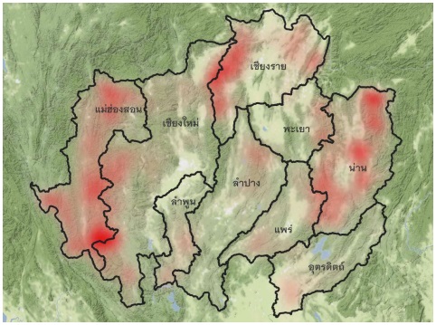
Open data can be increased the performance of government services and economic growth in private sector. Benefits of open data utilization are turn data and knowledge into new business models and innovation data services. This study aims to explore various sources of available open data for demonstrating the use of open data to analysis spatial distribution and to quantify of occurred hotspots in the Northern Thailand. Administrative boundary and the hotspots data from Fire Information for Resource Management System (NASA FIRMS) are used as a dataset, coupled with spatial analysis technique; Kernel density estimation, for examining the hotspot occurrences. The results show the pattern and distribution of occurred hotspots of Northern Thailand from 2001 - 2020. The three most found hotspots are in Mae Hong Son, Chiang Mai, and Nan province and the most occurred hotspots are on March, 55 percent of found hotspots, April, and February respectively.
References
Amri, K. & Sitanggang, I. S. (2015). A Geographic Information System for Hotspot Occurrences Classification in Riau Province Indonesia. Procedia Environmental Sciences, 24, 127-131, DOI: 10.1016/j.proenv.2015.03.017.
Cambridge University Press. (2021). Meaning of hotspot in English. Retrieved 19 July 2021 from https://dictionary.cambridge.org/dictionary/english/hotspot
NASA Fire Information for Resource Management System (NASA FIRMS). (2021). Fire Information for Resource Management System (FIRMS). Retrieved 19 July 2021 from https://earthdata.nasa.gov/earth-observation-data/near-real-time/firms
Open Knowledge Foundation (2021). What is Open Data ?. Retrieved 12 July 2021 from https://opendatahandbook.org/guide/en/what-is-open-data/
Pratamsari, A., Permatasari, N., Pramudiyasari, T., Manessa, M. & Supriatna. (2020). Spatial Distribution Patterns Analysis of Hotspot in Central Kalimantan using FIRMS MODIS Data. Journal of Geography of Tropical Environments, 4(1), 24-34.
Silva, C. A., Santilli, G., Sano, E. E. & Laneve, G. (2019). Hot Spots Occurrence in the Dynamics of Deforestation In The Amazon Rainforest. IGARSS 2019 - 2019 IEEE International Geoscience and Remote Sensing Symposium, 6594-6597, DOI: 10.1109/IGARSS.2019.8897946.
Sitanggang, I. S., Yaakob, R., Mustapha, N. & Ainuddin. A. N. (2013). Predictive Models for Hotspots Occurrence using Decision Tree Algorithms and Logistic Regression. Journal of Applied Sciences, 13(2), 252-261, DOI: 10.3923/jas.2013.252.261
United States Geological Survey (USGS). (2021). USGS EROS Archive - Advanced Very High Resolution Radiometer (AVHRR) - Sensor Characteristics. Retrieved 19 July 2021 from https://www.usgs.gov/centers/eros/science/usgs-eros-archive-advanced-very-high-resolution-radiometer-avhrr-sensor?qt-science_center_objects=0#qt-science_center_objects.
Yukili, L., Nuruddin, A. A.,Malek, I. A. A. & Razali, S. M. (2016). Analysis of Hotspot Pattern Distribution at Sabah, Malaysia for Forest Fire Management. Journal of Environmental Science and Technology. 9. 291-295, DOI: 10.3923/jest.2016.291.295.
กรมอุทยานแห่งชาติ สัตว์ป่า และพันธุ์พืช กระทรวงทรัพยากรธรรมชาติและสิ่งแวดล้อม. (2561). บันทึกยุทธศาสตร์/มาตรการแก้ไขปัญหาไฟป่า 2561. สืบค้นเมื่อวันที่ 12 กรกฎาคม 2564, จาก http://www.dnp.go.th/forestfire/web/frame/2561/Forestfire2561.pdf
สำนักงานพัฒนาเทคโนโลยีอวกาศและภูมิสารสนเทศ (องค์การมหาชน). (2559). ไฟป่า 2559 ใช้ดาวเทียม รู้ได้. สืบค้นเมื่อวันที่ 19 กรกฎาคม 2564, จาก https://gistda.or.th/main/th/node/1153
สำนักงานพัฒนาเทคโนโลยีอวกาศและภูมิสารสนเทศ (องค์การมหาชน). (2563). สรุปสถานการณ์ไฟป่าและ หมอกควัน ด้วยภาพถ่ายจากดาวเทียม ประจำปี 2563. สืบค้นเมื่อวันที่ 12 กรกฎาคม 2564, จาก http://fire.gistda.or.th/fire_report/Fire_2563.pdf
สำนักงานพัฒนารัฐบาลดิจิทัล (องค์การมหาชน). (2564). สืบค้นเมื่อวันที่ 12 กรกฎาคม 2564, จาก https://data.go.th/pages/about-open-data
สำนักบริหารพื้นที่อนุรักษ์ที่ 16 (เชียงใหม่). (2554). ความรู้เรื่องไฟป่า. สืบค้นเมื่อวันที่ 20 กรกฎาคม 2564, จาก http://www.fca16.com/newblog/blog.php?id=forestfire41
สำนักป้องกัน ปราบปรามและควบคุมไฟป่า กรมอุทยานแห่งชาติ สัตว์ป่า และพันธุ์พืช กระทรวงทรัพยากรธรรมชาติและสิ่งแวดล้อม. (2564). ความจริงเรื่อง Hotspot. สืบค้นเมื่อวันที่ 19 กรกฎาคม 2564, จาก https://www.dnp.go.th/forestfire/hotspot/hotspot.htm