An Analysis and Sinkhole Risk Assessment in Southern of Thailand: A Case Study of Surat Thani Province
Keywords:
Risk Assessment, Risk Area, Sinkhole, Southern of Thailand, Surat Thani Province, GISAbstract
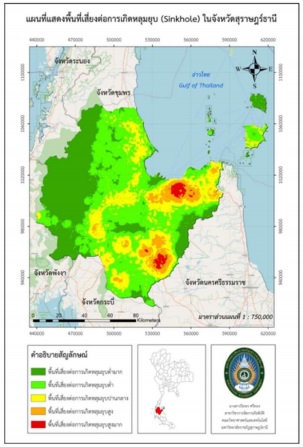
This study aimed to study and analyze factors related to the disaster of sinkhole, will lead to an assessment of the disaster-prone areas of sinkhole in Surat Thani province to propose guidelines for the prevention and mitigation of the impact of sinkhole disaster in the future. The data used for the analysis consisted of primary and secondary data from both local and central agencies together with the relevant factor assessment form from experts. This research uses the spatial analysis technique or Potential Spatial Analysis (PSA) in the overlay of factor data by GIS. The results of the study of risk factors for sinkhole in Surat Thani province found that the most important factor from weighting and score value of experts in the analysis of sinkhole risk areas was the density of the birth location sinkhole in the past 10 years, as areas with high collapse density exhibit similar locations or topography, they have a fairly frequent birth history and birth location, and are highly vulnerable and the second most important factor are the distance from the point of collapse in the past 10 years, the density of the underground source, the distance from the groundwater location point, soil group data, land use, height from mean sea level and slope factor, respectively. When overlapping all factors to classify disaster risk areas of sinkhole, the study found that Surat Thani province has most of the areas at very low risk of sinkhole disaster, followed by low, medium, high and very high risk areas respectively. And the analysis of risk areas by districts of all 19 districts of Surat Thani province was found the districts most at risk of collapsing are Wiang Sa district, Kanchanadit district and Khiansa district and the areas with very low or less risk of collapsing than other areas are Koh Phangan district, Ban Ta Khun district and Phanom district. As for the project guidelines related to disaster preparedness of sinkhole in Surat Thani province, it was found that both local and provincial government agencies did not give priority to such problems due to the statistics of the collapse, most of the resulting areas are agricultural areas and essentially empty space, shows the possibility of ignoring such disasters and the lack of proper management to mitigate future losses.