Geo-Informatics Technology for Managing Flood Risk Areas in Surat Thani Province
Keywords:
Flood, Risk Areas, Geo-Informatics Technology, Surat Thani ProvinceAbstract
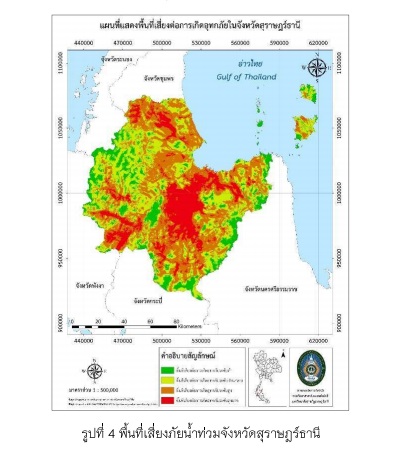
Accurate flood risk assessments are key component of flood risk management plans. The objectives of this research are to study the physical factors that affect the flooding, determine the risk areas and consider the policy plan including the preparation for floods in Surat Thani province by applying geo-informatics technology which are Remote Sensing (RS), Global Positioning System (GPS), Geographic Information System (GIS) and Potential Surface Analysis (PSA). The results of the study show that there are 9 factors affecting Surat Thani flood, consisting of the latest 5 years flooding, average rainfall for the past 10 years, density of water obstacles, water route density, water route distance, soil drainage, height from mean sea level, slope and land use. According to overlapping factors, it shows that most areas of Surat Thani province are moderate flood risk areas, followed by high flood risk areas, very high risk of flooding areas with low flood risk, respectively. In addition, the research also illustrates that Surat Thani province lacks of flood risk management plans and policies and transportation facilitation in flood risk areas. Therefore, the research is an important tool in supporting flood risk management plans, especially in areas with high risk of flooding.