สารสนเทศเชิงพื้นที่เพื่อการจัดการระบบสุขภาพชายแดนในกลุ่มผู้มีปัญหาสถานะบุคคลและประชากรข้ามชาติ
คำสำคัญ:
ระบบสารสนเทศภูมิศาสตร์, ผู้มีปัญหาสถานะบุคคลและประชากรข้ามชาติ, ระบบสุขภาพชายแดนบทคัดย่อ
บทความนี้มีวัตถุประสงค์เพื่อศึกษาสถานการณ์และบริบทของผู้มีปัญหาสถานะบุคคลและประชากรข้ามชาติ
ในพื้นที่ชายแดนไทย–ลาว อำเภอท่าลี่ จังหวัดเลย ซึ่งเป็นกลุ่มประชากรที่มีข้อจำกัดในการเข้าถึงสิทธิและบริการสุขภาพ
การดำเนินการวิจัยอาศัยการสำรวจแบบมีส่วนร่วมเพื่อเก็บข้อมูลสถานภาพความเป็นอยู่และปัญหาของกลุ่มเป้าหมาย ควบคู่กับการเก็บพิกัดที่อยู่อาศัยโดยใช้ระบบนำทางด้วยดาวเทียม (GNSS: Global Navigation Satellite System) และการพัฒนา
ระบบสารสนเทศเชิงพื้นที่ผ่านระบบสารสนเทศภูมิศาสตร์ (GIS: Geographic Information System) เพื่อวิเคราะห์จำนวนการกระจายตัว และสร้างฐานข้อมูลเชิงพื้นที่สำหรับสนับสนุนการตัดสินใจในการจัดการสุขภาพชายแดน
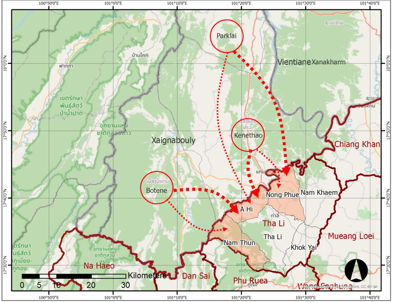
ผลการศึกษาพบว่า อำเภอท่าลี่ จังหวัดเลย เป็นเมืองชายแดนที่ติดกับเมืองแก่นท้าว แขวงไชยบุรี สปป.ลาว โดยมีชุมชนตั้งถิ่นฐานริมแม่น้ำเหือง ซึ่งเป็นแม่น้ำพรหมแดนขนาดเล็กและสามารถข้ามแดนได้โดยง่าย การสำรวจพบผู้มีปัญหาสถานะบุคคลจำนวน 991 ราย ระบบสารสนเทศเชิงพื้นที่ที่พัฒนาขึ้นสามารถแสดงตำแหน่งและการกระจายตัวของบ้านพักอาศัย พร้อมทั้งการวิเคราะห์เชิงลึกที่สะท้อนประเด็นสำคัญ เช่น ประชากรร้อยละ 70.74 เป็นเพศหญิง ร้อยละ 66.30 ไม่เคยเดินทางกลับประเทศต้นทาง และร้อยละ 34.71 ไม่มีเอกสารประจำตัว ส่งผลให้ไม่สามารถเข้าถึงสิทธิและบริการสุขภาพได้ นอกจากนี้ การเชื่อมโยงข้อมูลเชิงตำแหน่งกับแผนที่ภาพถ่ายดาวเทียมยังสามารถแสดงผลได้อย่างเป็นรูปธรรม สนับสนุนการตัดสินใจในการกำหนดพื้นที่เป้าหมาย การติดตาม และการจัดการระบบสุขภาพชายแดนอย่างแม่นยำ เช่น การจำแนกประชากรตามถิ่นที่อยู่ เพศ อายุ ประเภทเอกสาร ปัญหาสุขภาพ และเครือข่ายความไว้วางใจ
ประเด็นเร่งด่วนที่พบคือ ประชากรกลุ่มนี้ยังขาดความรู้ความเข้าใจเกี่ยวกับกระบวนการพัฒนาสถานะบุคคลและสิทธิประโยชน์ที่ควรได้รับ โดยเฉพาะสิทธิในการรักษาพยาบาลในหน่วยบริการของรัฐ ภายใต้บริบทที่ประชากรส่วนใหญ่เป็นเพศหญิงและผู้สูงอายุ ซึ่งมีความเสี่ยงด้านสุขภาพและโรคประจำตัว จึงควรมีมาตรการและแนวทางที่ชัดเจนจากหน่วยงานที่เกี่ยวข้อง โดยเฉพาะหน่วยบริการสุขภาพของรัฐ เพื่อให้สามารถดูแลและแก้ไขปัญหาได้อย่างต่อเนื่องและยั่งยืน
เอกสารอ้างอิง
Amornsanguansin. J. (2012). Geographic information system for sustainable development. Journal of Environmental Management, 3(2), 220–252. (in Thai)
Buckle, C. (2020). Touching, scrolling and swooping: Performing and representing migrant stories through geospatial technologies. Geoforum. 111, 83–93.
Chuayrai, P., & Songthap, A. (2019). Application of geographic information systems in public health. Southern Network Journal of Nursing and Public Health Colleges, 6(3), 229–236. (in Thai)
Department of Health, Ministry of Public Health. (2020). Guidelines for basic data collection and environmental health surveillance in the Eastern Economic Corridor. Retrieved November 8, 2023, From https://hia.anamai.moph.
go.th/web-upload/migrated/files/hia/n3040_ad0fbb1a2860cf17bfe17b82a54bce14_EEC63_01.pdf. (in Thai)
Department of National Parks, Wildlife and Plant Conservation. (2019). Manual for the application of Quantum GIS (QGIS) program for natural resource conservation work. Bangkok: Geo-Informatics Division, Information and Communication Technology Center. (in Thai)
Geo-Informatics and Space Technology Development Agency (Public Organization). (2023). How prominent and hot is GIS technology in daily life. Retrieved September 30, 2023, From https://www.gistda.or.th/news_view.php?n_id=6953&lang=TH. (in Thai)
Hoomhong, C. (2019). QGIS professional: A professional guide to using QGIS. Phitsanulok: Mappidia Co., Ltd. (in Thai)
Kakembo, V., & Van, S. (2014). The integration of GIS into demographic surveying of informal settlements: The case of Nelson Mandela Bay Municipality, South Africa. Habitat International, 44, October, 451-460.
Meehl, J. (2008). Using GIS and other location based tools for the registration, design, maintenance, and mapping of refugee camps. Saint Mary’s University of Minnesota University Central Services Press. Winona, MN.
Office for Academic Promotion and Support, 8 Provinces of Lopburi, Ministry of Social Development and Human Security. (2019). Geographic information system for social development: Quantum 3.4 Madeira. Lopburi. (in Thai)
Pongcharoen, P., Duangpastra, C., Wisetruangroj, S., Krebs, N., Phochan, J., & Wijitpongsa, W. (2021). Research report on the development of the potential of Thai-Lao border checkpoints. Bangkok: National Research Council of Thailand. (in Thai)
Sukkhlom, P. (2004). Laotian migrant workers in Northeastern Thailand: A case study of Laotian migrant workers in Mukdahan Province (Master’s thesis). Khon Kaen: Khon Kaen University. (in Thai)
Sunthornnon, T. (2023). Components, indicators, and strategic recommendations for developing the competency of village health volunteers in the digital era: The case of Trang Province. Khon Kaen University Journal of Public Health Research, 16(2), 58–73. (in Thai)
Taburi, W., Hoomhong, C., & Narongrit, C. (2020). An online geographic information system prototype to support elderly health care in communities. Srinagarind Medical Journal, 35(1), 59–65. (in Thai)
Thawisit, S. (2009). Imagined citizens and stateless Laotians at the Northeastern border. Journal of Arts, Ubon Ratchathani, Special Issue. (in Thai)
Thongyu, M., & Auywat, D. (2005). Social networks of Laotian migrant workers in Thailand. Mekong Basin Social Journal, 1(2), 55–56. (in Thai)
Tina, Y. (2018). A study of border area potential: A case study of Ban Nakraseng border checkpoint, Tha Li District, Loei Province (Master’s thesis). Bangkok: Thammasat University. (in Thai)
United Nations High Commissioner for Refugees (UNHCR), Thailand Office. (n.d.). Stateless persons. Retrieved September 12, 2023, From https://www.unhcr.org/th/statelessness. (in Thai)