การประยุกต์ใช้ระบบสารสนเทศภูมิศาสตร์เพื่อการวิเคราะห์ข้อมูลเชิงพื้นที่การรับเข้านิสิตและการพัฒนาเส้นทางแนะแนวการศึกษาในภาคตะวันออกเฉียงเหนือ: กรณีศึกษา คณะเทคโนโลยีสารสนเทศและการสื่อสาร มหาวิทยาลัยพะเยา
คำสำคัญ:
การวิเคราะห์โครงข่าย, การตัดสินใจแบบหลายหลักเกณฑ์, ระบบสารสนเทศภูมิศาสตร์, การแนะแนวการศึกษา, คณะเทคโนโลยีสารสนเทศและการสื่อสาร, มหาวิทยาลัยพะเยาบทคัดย่อ
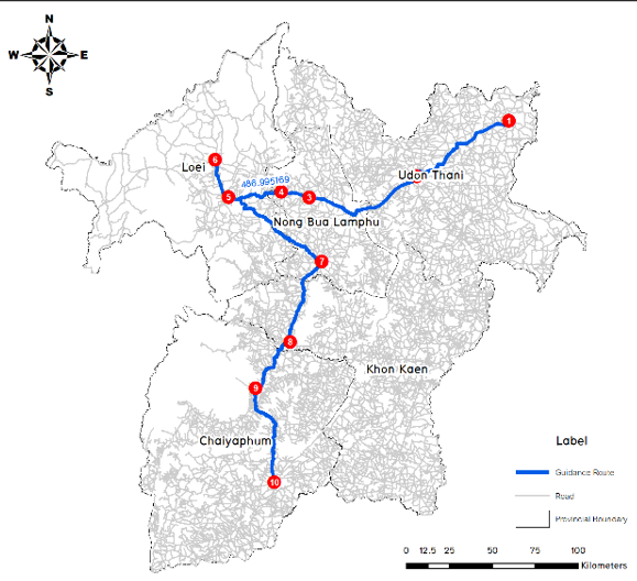
การวิจัยนี้มีวัตถุประสงค์เพื่อวิเคราะห์ข้อมูลการรับเข้านิสิตระดับปริญญาตรีของคณะเทคโนโลยีสารสนเทศและการสื่อสาร มหาวิทยาลัยพะเยา ในเชิงพื้นที่และวางแผนเส้นทางแนะแนวการศึกษาในภาคตะวันออกเฉียงเหนืออย่างมีประสิทธิภาพ โดยประยุกต์ใช้ระบบสารสนเทศภูมิศาสตร์ (GIS) และการวิเคราะห์โครงข่าย (Network Analysis) จากข้อมูลที่ใช้ในการวิจัยคือข้อมูลการรับเข้านิสิตช่วงปีการศึกษา 2554 – 2567 รวมระยะเวลา 14 ปี ผู้วิจัยวิเคราะห์ความถี่เชิงพื้นที่และคัดเลือกโรงเรียนที่มีความเหมาะสมเข้าแนะแนวด้วยวิธีถ่วงน้ำหนักแบบอย่างง่าย (Simple Additive Weighting: SAW) โดยใช้ 2 ปัจจัย ได้แก่ จำนวนผู้สำเร็จการศึกษาที่เข้าศึกษาต่อ และช่วงเวลาของปีการศึกษา ผลการวิจัยพบโรงเรียนที่เหมาะสมสำหรับการเข้าแนะแนวจำนวน 10 แห่ง และสามารถสร้างแบบจำลองฉากทัศน์ (Multi scenarios) ใน 3 รูปแบบ ได้แก่ (1) เส้นทางระยะทางสั้นที่สุด 487 กม. ใช้เวลา 365 นาที, (2) เส้นทางย้อนกลับสู่ศูนย์กลาง 589.08 กม. ใช้เวลา 442 นาที, และ (3) เส้นทางแบบต่อเนื่อง 477.8 กม. ใช้เวลา 358 นาที ผลการศึกษานี้ช่วยให้การแนะแนวการศึกษามีประสิทธิภาพ ตรงกลุ่มเป้าหมาย และสามารถใช้เป็นแนวทางในการขยายโอกาสการเข้าถึงการศึกษาอย่างเท่าเทียม สอดคล้องกับเป้าหมายการพัฒนาที่ยั่งยืน และสนับสนุนการเรียนรู้ตลอดชีวิต
เอกสารอ้างอิง
Bureau of Registration Administration, Ministry of Interior. (2024). Birth statistics of Thailand, January–November 2024. Bangkok: Bureau of Registration Administration, Ministry of Interior. (in Thai)
Burrough, P. A., & McDonnell, R. A. (1998). Principles of geographical information systems. Oxford University Press.
ESRI. (2021). ArcGIS Pro Documentation. Retrieved From https://pro.arcgis.com.
Fotheringham, A. S., Brunsdon, C., & Charlton, M. (2000). Quantitative geography: Perspectives on spatial data analysis. Sage.
Geurs, K. T., & van Wee, B. (2004). Accessibility evaluation of land-use and transport strategies: Review and research directions. Journal of Transport Geography, 12(2), 127–140.
Goodchild, M. F. (2007). Citizens as sensors: The world of volunteered geography. GeoJournal, 69(4), 211–221.
Hansen, W. G. (1959). How accessibility shapes land use. Journal of the American Institute of Planners, 25(2), 73–76.
Kraak, M. J., & Ormeling, F. J. (2020). Cartography: Visualization of Geospatial Data (4th ed.). Routledge.
Longley, P. A., Goodchild, M. F., Maguire, D. J., & Rhind, D. W. (2015). Geographic Information Science and Systems (4th ed.). Wiley.
Malczewski, J. (2006). GIS-based multicriteria decision analysis: A survey of the literature. International Journal of Geographical Information Science, 20(7), 703–726.
Manichda, K. (2012). Educational guidance to create educational opportunities. Bangkok: Thai Education Publishing. (in Thai)
Manichda, K. (2012). Factors affecting the decision to continue undergraduate studies in the vocational-to-degree program of vocational students in Phra Nakhon Si Ayutthaya Province [Master’s thesis]. Phra Nakhon Si Ayutthaya: Rajabhat Phra Nakhon Si Ayutthaya University]. (in Thai)
Niti, E., Boonsiri, S., Nakarin, C., & Thida, P. A. Y. (2023). Network analysis of waste collection systems and guidelines for finding landfill areas: A case study of Songkhla Municipality, Songkhla Province. Burapha Science Journal, 28(1), 364–383. (in Thai)
Pimphat, P., & colleagues. (2025). Analysis of agri-tourism routes using geographic information systems: A case study of Ban Khao Subdistrict, Ranot District, Songkhla Province. Thai Journal of Geoinformatics, 17(1), 85–100. (in Thai)
Somsak, P. (2019). Educational guidance and career planning. Khon Kaen: Khon Kaen University. (in Thai)
Sumet, S., & colleagues. (2015). Analysis of community tourism route networks using GIS: A case study of Chanthaburi and Trat Provinces. Journal of Community Development Research, 8(2), 57–72. (in Thai)
Sumet, S., & colleagues. (2015). Developing community tourism routes using GIS and network analysis. Journal of Tourism Research, 8(2), 100–115. (in Thai)
Tang, J., Wang, L., & Yao, Z. (2014). Network analysis in urban planning: A GIS-based study. Urban Studies, 51(5), 1022–1038.
Tanit, T., & colleagues. (2025). Analysis of connecting routes for old town cultural sites to support community tourism. Journal of Urban Development Research, 15(1), 23–38. (in Thai)
Thanyarat, C. (2017). Application of GIS for analyzing tourism routes in the “12 Must-Visit Cities” area. Thai Journal of Tourism Management, 5(3), 101–115. (in Thai)
Thirakultomorn, T., Tiyawongsuwan, S., Prasomsup, W., & Phinyoyang, A. (2025). Application of geoinformatics technology for route management connecting the cultural sites of Korat’s old town. Journal of Spatial Innovation Development (JSID), 6(1), 77–92. (in Thai)
Triantaphyllou, E. (2000). Multi-Criteria Decision Making Methods: A Comparative Study. Springer.
UNESCO. (2017). Education for Sustainable Development Goals: Learning Objectives. Paris: UNESCO.
United Nations. (2015). Transforming our world: the 2030 Agenda for Sustainable Development.
University of Phayao Act B.E. 2553. (2010). Royal Gazette, 127(28a), 1–8. Retrieved From http://www.ratchakitcha.soc.go.th. (in Thai)
Yoon, K. P., & Hwang, C. L. (1995). Multiple Attribute Decision Making: An Introduction. Sage Publications.