Geospatial AI for Strategic Ecosystem Restoration: Prioritizing Critical Hotspots in Tham Luang-Khun Nam Nang Non National Park (under gazetting)
Keywords:
Geoinformatics, Machine learning, Spatial risk assessment, Ecosystem restoration, Geoinformatics, Machine Learning, Spatial Risk Assessment, Ecosystem Restoration, Slope, Tham Luang, Tham LuangAbstract
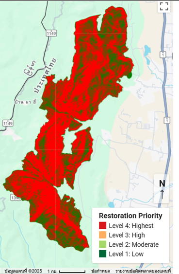
Tham Luang-Khun Nam Nang Non National Park (under gazetting) (proposed), covering approximately 12,000 rai, represents a fragile ecosystem facing high risks of soil erosion and forest degradation. This research aims to develop a systematic spatial model for prioritizing ecosystem restoration areas by integrating geospatial techniques on the Google Earth Engine (GEE) platform with machine learning. The primary data included Sentinel-2 satellite imagery from 2024 and a Digital Elevation Model (DEM) to assess three spatial risk factors: Slope, Normalized Difference Vegetation Index (NDVI), and Land Use. Scoring criteria and importance weights were determined through expert consensus. Land use classification utilizing the Random Forest algorithm, validated through a 70:30 split-validation method, achieved an Overall Accuracy of 88.24% and a Kappa Coefficient of 0.82. Through Multi-Criteria Evaluation (MCE), assigning the highest weight to slope (50.00%), results indicate that areas requiring high to highest restoration priority (Levels 3 and 4) comprise a total of 5,340.94 rai (44.48%) of the park. The majority of these areas fall under the high priority category (Level 3), covering 5,322.64 rai. Notably, the highest urgency areas (Level 4), covering 18.30 rai, are characterized by extremely steep slopes and sparse vegetation. The resulting prioritization map serves as a critical strategic decision-support tool for optimizing resource allocation in ecosystem restoration projects.
References
Belgiu, M., & Drǎguţ, L. (2016). Random forest in remote sensing: A review of applications and future directions. ISPRS Journal of Photogrammetry and Remote Sensing, 114, 24–31. form https://doi.org/10.1016/j.isprsjprs.2016.01.011.
Chuvieco, E., & Huete, A. (2020). Fundamentals of satellite remote sensing: An environmental approach (3rd ed.). CRC Press.
Cochran, W. G. (1977). Sampling techniques (3rd ed.). John Wiley & Sons.
Department of National Parks, Wildlife and Plant Conservation. (2022). Management Plan for Tham Luang-Khun Nam Nang Non National Park (under gazetting), 2023-2027. (in Thai).
Food and Agriculture Organization (FAO). (2006). Guidelines for soil description (4th ed.). FAO.
Gorelick, N., Hancher, M., Dixon, M., Ilyushchenko, S., Thau, D., & Moore, R. (2017). Google Earth Engine: Planetary-scale geospatial analysis for everyone. Remote Sensing of Environment, 202, 18–27. form https://doi.org/10.1016/j.rse.2017.06.031.
Malczewski, J. (2006). GIS-based multicriteria decision analysis: A survey of the literature. International Journal of Geographical Information Science, 20(7), 703–726. form https://doi.org/10.1080/13658810600661508.
Rouse, J. W., Haas, R. H., Schell, J. A., & Deering, D. W. (1974). Monitoring vegetation systems in the Great Plains with ERTS. NASA Special Publication, 351, 309.
Sudana, I. W., Danoedoro, P., & Hartono, H. (2020). Soil erosion hazard assessment using GIS and remote sensing in mountain area of Bali, Indonesia. IOP Conference Series: Earth and Environmental Science, 478(1), 012028. form https://doi.org/10.1088/1755-1315/478/1/012028.
United Nations. (n.d.). The UN Decade on Ecosystem Restoration. Retrieved from https://www.decadeonrestoration.org/.
Vrieling, A., Sterk, G., & de Jong, S. M. (2011). Satellite-based assessment of ecosystem degradation in the Ethiopian Highlands. Land Degradation & Development, 22(3), 263-276. form https://doi.org/10.1002/ldr.1017.