Spatial Information for Border Health System Management in Stateless Persons and Migrant Working Group
Keywords:
Geographic information systems, Stateless persons and migrant working group, Border health systemAbstract
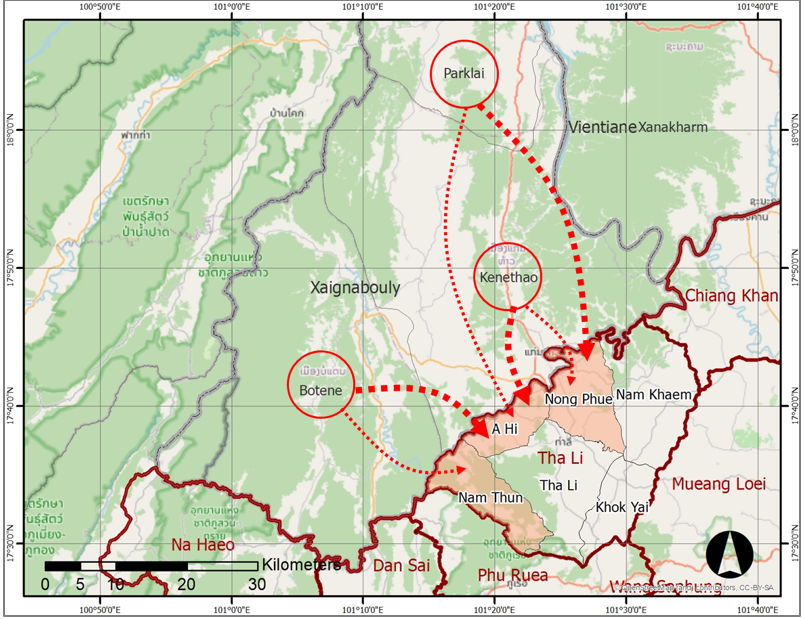
This study aims to examine the situation and context of stateless persons and cross-border migrants in the Thai–Lao border area, Tha Li District, Loei Province, who face significant limitations in accessing rights and healthcare services. The research employed participatory surveys to collect data on living conditions and challenges of the target population, combined with geospatial data collection of residential locations using the Global Navigation Satellite System (GNSS). A spatial information system was developed through Geographic Information System (GIS) technology to analyze population numbers, spatial distribution, and to build a geospatial database supporting decision-making in border health management.
The study found that Tha Li District, Loei Province, is a border town adjacent to Kaen Thao district, in Xayaburi Province, Lao PDR, with communities settled along the Hueang River, a small border river that can be easily crossed. The survey identified 991 stateless persons. The developed spatial information system was able to visualize household locations and distribution, along with in-depth analyses highlighting key issues: 70.74% of the population are female, 66.30% have never returned to their country of origin, and 34.71% lack identity documents-factors that restrict access to rights and healthcare services. Moreover, linking positional data with satellite imagery provided concrete insights that support precise decision-making in defining target areas, monitoring, and managing border health. This includes population classification by residence, gender, age, document type, health conditions, and trust networks.
An urgent concern is the lack of knowledge and understanding among this group regarding the processes of legal status development and their entitled benefits, particularly the right to healthcare in public service units. Given that most of the population are women and elderly persons-groups at higher risk of health problems and chronic diseases—clear and systematic measures are needed from relevant agencies, especially public health service providers, to ensure continuous and sustainable solutions.
References
Amornsanguansin. J. (2012). Geographic information system for sustainable development. Journal of Environmental Management, 3(2), 220–252. (in Thai)
Buckle, C. (2020). Touching, scrolling and swooping: Performing and representing migrant stories through geospatial technologies. Geoforum. 111, 83–93.
Chuayrai, P., & Songthap, A. (2019). Application of geographic information systems in public health. Southern Network Journal of Nursing and Public Health Colleges, 6(3), 229–236. (in Thai)
Department of Health, Ministry of Public Health. (2020). Guidelines for basic data collection and environmental health surveillance in the Eastern Economic Corridor. Retrieved November 8, 2023, From https://hia.anamai.moph.
go.th/web-upload/migrated/files/hia/n3040_ad0fbb1a2860cf17bfe17b82a54bce14_EEC63_01.pdf. (in Thai)
Department of National Parks, Wildlife and Plant Conservation. (2019). Manual for the application of Quantum GIS (QGIS) program for natural resource conservation work. Bangkok: Geo-Informatics Division, Information and Communication Technology Center. (in Thai)
Geo-Informatics and Space Technology Development Agency (Public Organization). (2023). How prominent and hot is GIS technology in daily life. Retrieved September 30, 2023, From https://www.gistda.or.th/news_view.php?n_id=6953&lang=TH. (in Thai)
Hoomhong, C. (2019). QGIS professional: A professional guide to using QGIS. Phitsanulok: Mappidia Co., Ltd. (in Thai)
Kakembo, V., & Van, S. (2014). The integration of GIS into demographic surveying of informal settlements: The case of Nelson Mandela Bay Municipality, South Africa. Habitat International, 44, October, 451-460.
Meehl, J. (2008). Using GIS and other location based tools for the registration, design, maintenance, and mapping of refugee camps. Saint Mary’s University of Minnesota University Central Services Press. Winona, MN.
Office for Academic Promotion and Support, 8 Provinces of Lopburi, Ministry of Social Development and Human Security. (2019). Geographic information system for social development: Quantum 3.4 Madeira. Lopburi. (in Thai)
Pongcharoen, P., Duangpastra, C., Wisetruangroj, S., Krebs, N., Phochan, J., & Wijitpongsa, W. (2021). Research report on the development of the potential of Thai-Lao border checkpoints. Bangkok: National Research Council of Thailand. (in Thai)
Sukkhlom, P. (2004). Laotian migrant workers in Northeastern Thailand: A case study of Laotian migrant workers in Mukdahan Province (Master’s thesis). Khon Kaen: Khon Kaen University. (in Thai)
Sunthornnon, T. (2023). Components, indicators, and strategic recommendations for developing the competency of village health volunteers in the digital era: The case of Trang Province. Khon Kaen University Journal of Public Health Research, 16(2), 58–73. (in Thai)
Taburi, W., Hoomhong, C., & Narongrit, C. (2020). An online geographic information system prototype to support elderly health care in communities. Srinagarind Medical Journal, 35(1), 59–65. (in Thai)
Thawisit, S. (2009). Imagined citizens and stateless Laotians at the Northeastern border. Journal of Arts, Ubon Ratchathani, Special Issue. (in Thai)
Thongyu, M., & Auywat, D. (2005). Social networks of Laotian migrant workers in Thailand. Mekong Basin Social Journal, 1(2), 55–56. (in Thai)
Tina, Y. (2018). A study of border area potential: A case study of Ban Nakraseng border checkpoint, Tha Li District, Loei Province (Master’s thesis). Bangkok: Thammasat University. (in Thai)
United Nations High Commissioner for Refugees (UNHCR), Thailand Office. (n.d.). Stateless persons. Retrieved September 12, 2023, From https://www.unhcr.org/th/statelessness. (in Thai)