The application of unmanned aerial vehicle images for the classification of coral reef area at Man Nai Island, Rayong Province
Keywords:
Unmanned aerial vehicle, Aerial photography, Water column correction, Man Nai IslandAbstract
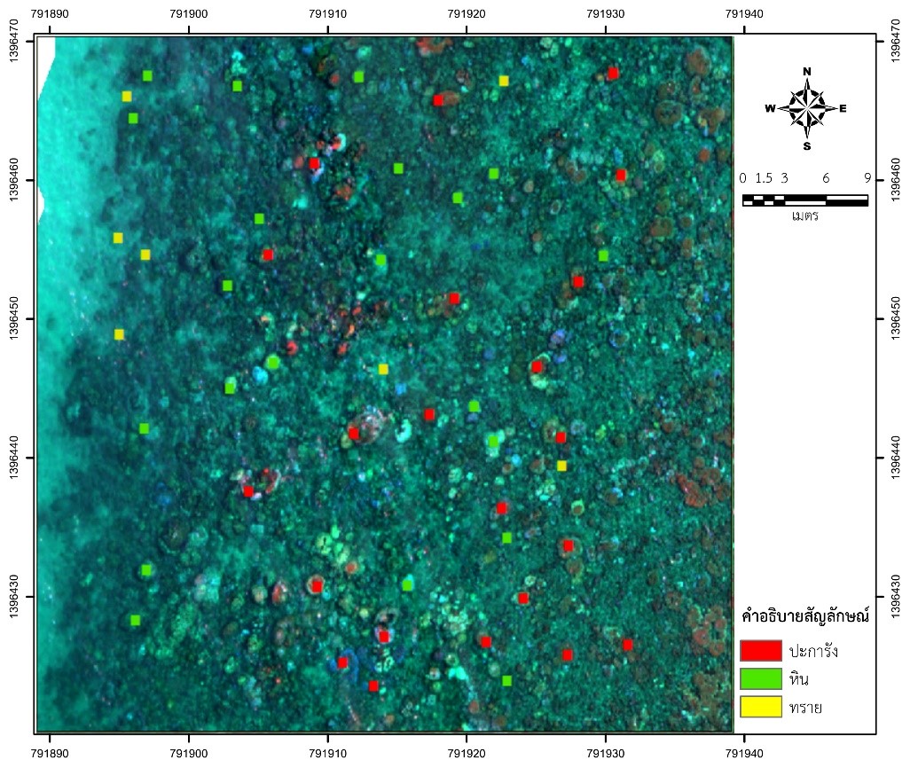
The application of unmanned aerial vehicles (UAVs) to study the classification of coral reef areas around Koh Man Nai in Rayong Province involved the use of Pixel-based classification. This method utilized three models: Maximum Likelihood (ML), Random Trees (RT), and Support Vector Machine (SVM) at 100-meters and 200-meters flight altitudes, categorizing the reef into three types: coral, rocks, and sand. The assessment of coral reef classification accuracy at 100-meters flight altitude using SVM revealed the highest overall accuracy at 72.73%. The Kappa coefficient was 0.748. Comparatively, ML achieved an overall accuracy of 70.91% with a Kappa coefficient of 0.719, while RT showed the least accuracy at 62.27% with a Kappa coefficient of 0.675. Similarly, at 200-meters flight altitude, SVM demonstrated the highest overall accuracy of 67.27%, with a Kappa coefficient of 0.689. ML and RT achieved lower overall accuracies at 65.45% (Kappa coefficient: 0.651) and 63.3% (Kappa coefficient: 0.633), respectively. The results show that the drone's altitude affects the accuracy of land cover classification. Flying at lower altitudes leads to more accurate land cover classification results. SVM stands out as the model that provides the highest accuracy in classification analysis.
References
กรมทรัพยากรทางทะเลและชายฝั่ง. (2556). ข้อมูลภูมิสารสนเทศทรัพยากรทางทะเลและชายฝั่ง. กรุงเทพฯ: มหาวิทยาลัยราชภัฏพระนคร.
กรมทรัพยากรทางทะเลและชายฝั่ง. (2558). ข้อมูลภูมิสารสนเทศทรัพยากรทางทะเลและชายฝั่ง ฉบับปรับปรุงข้อมูลตามพระราชบัญญัติส่งเสริมการบริหารจัดการทรัพยากรทางทะเลและชายฝั่ง พ.ศ.2558. กรุงเทพฯ: สำนักงานพระพุทธศาสนาแห่งชาติ.
ทรัน วัน นินห์ และชาติชาย ไวยสุระสิงห์ (2560). การศึกษาเปรียบเทียบวิธีแบบความน่าจะเป็นได้สูงที่สุด กับ วิธีแบบซัพพอร์ตเวกเตอร์แมชชีนในการวิเคราะห์ข้อมูลภาพดาวเทียม Landsat เพื่อประเมินการเปลี่ยนแปลงการใช้ที่ดินในเมืองขอนแก่น. วารสารวิจัย มข. 17(4), 49-60.
ปราณี นวลละออง และ หทัยกาญจน์ วิริยะสมบัติ. (2562). การประยุกต์ใช้ภูมิสารสนเทศในการกําหนดเขตพื้นที่คุ้มครองทรัพยากรหญ้าทะเล บริเวณเกาะท่าไร่ จังหวัดนครศรีธรรมราช. วารสารมนุษยศาสตร์และสังคมศาสตร์ มหาวิทยาลัยราชภัฏสงขลา, 1(1), 1-8.
วิภารัตน์ อัมพะวัน. (2561). การศึกษาเทคนิคการประมาณสภาพกายภาพต้นยางพาราจากข้อมูลอากาศยานไร้คนขับ. (วิทยานิพนธ์ระดับปริญญาตรี). สาขาภูมิศาสตร์, มหาวิทยาลัยนเรศวร, พิษณุโลก.
ศูนย์ปฏิบัติการอุทยานแห่งชาติทางทะเลที่ 1 จังหวัดชุมพร. (2560). การติดตามการฟื้นตัว และจัดการแนวปะการัง ภายหลังปรากฎการณ์ปะการังฟอกขาวในเขตอุทยานแห่งชาติทางทะเล รายงานการวิจัยอุทยานแห่งชาติ ปี 2560. ชุมพร: ศูนย์ปฏิบัติการอุทยานแห่งชาติทางทะเลที่ 1 จังหวัดชุมพร กรมอุทยานแห่งชาติ สัตว์ป่า และพันธุ์พืช.
สถาบันส่งเสริมการสอนวิทยาศาสตร์และเทคโนโลยี (สสวท.) กระทรวงศึกษาธิการ. (2553). คู่มือครูรายวิชาพื้นฐานชีววิทยา สำหรับนักเรียนที่เน้นวิทยาศาสตร์ชั้นมัธยมศึกษาปีที่ 4-6. กรุงเทพฯ สกสค.
สาลินี ขจรพิสิฐศักดิ์. (2559). โครงการความหลากหลายของมดในหมู่เกาะมัน (เกาะมันนอก เกาะมันกลางและเกาะมันใน) อำเภอแกลง จังหวัดระยอง ภาคตะวันออกของประเทศไทย. ชลบุรี: ภาควิชาชีววิทยา คณะวิทยาศาสตร์ มหาวิทยาลัยบูรพา.
สำนักอนุรักษ์ทรัพยากรทางทะเลและชายฝั่ง. (2556). คู่มือการทำกิจกรรมเรียนรู้ระบบนิเวศทางทะเลและชายฝั่ง : ระบบนิเวศแนวปะการังเกาะเต่า จังหวัดสุราษฎร์ธานี. กรุงเทพมหานคร: กรมทรัพยากรทางทะเลและชายฝั่ง กระทรวงทรัพยากรธรรมชาติและสิ่งแวดล้อม.
อานนท์ เบียงแล และสวรินทร์ ฤกษ์อยู่สุข. (2563). การศึกษาการจำแนกข้อมูลภาพด้วยวิธีซัพพอร์ตเวกเตอร์แมชชีน กรณีศึกษา พื้นที่เพาะปลูกข้าว อำเภอจุน จังหวัดพะเยา. วารสารวิชาการเพื่อการพัฒนานวัตกรรมเชิงพื้นที่, 1(3), 51-62.
ESRI. (2023). An overview of the Classification and Pattern Recognition toolset. Retrieved from https://pro.arcgis.com/en/pro-app/latest/tool-reference/image-analyst/an-overview-of-the-segmentation-and-classification-tools-in-image-analyst.htm.
Dajiang Innovation Technology. (2020). PHANTOM 4 RTK User Manual. Retrieved from https://dl.djicdn.com/downloads/phantom_4_rtk/20200721/Phantom_4_RTK_User_Manual_v2.4_EN.pdf.
Fahlstrom, P. G., & Gleason, T. J. (2021). Introduction to UAV Systems (4th ed.). United Kingdom: Wiley.
Medina, A. & Atehortúa, A. (2019). Comparison of Maximum Likelihood, Support Vector Machines, and Random Forest Techniques in Satellite Images Classification. Tecnura, 23, 13-26.
Saczuk, E. (2018). Processing UAS Photogrammetric Images in Agisoft Photoscan Professional. Retrieved from https://pressbooks.bccampus.ca/renegade/.
The Nature Conservancy. (2023). EI Nino Southern Oscillation. Retrieved from https://reefresilience.org/stressors/climate-and-ocean-change/el-nino-southern-oscillation/.