Multi-scenario Satellite Drought Assessment using Moisture Stress Index (MSI) in Mae Suk Watershed, Mae Chai District, Phayao Province
Keywords:
Remote sensing, Land use, Moisture Stress Index, Phayao, Upper Ing watershedAbstract
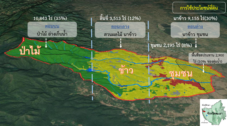
Drought is a natural disaster that has persisted from the past to the present. It can occur in any area and is usually caused by changes in rainfallThe amount of rainfall decreases more than usual for an extended period, affecting agricultural production. Current drought conditions can be assessed using indices calculated through remote sensing techniques. The Moisture Stress Index (MSI) is used to analyze drought-prone areas and their impact on land use. In this research study, the aims are (1) to analyze areas at risk of drought under varying rainfall amounts and (2) to examine the relationship between drought risk areas and land use status. The research results indicate that drought areas (ranging from moderate to extreme drought) appear in all three landscapes, with 10,193 rai in low rainfall areas, 13,654 rai in normal rainfall areas, and 5,736 rai in high rainfall areas. When analyzing the MSI index values in conjunction with land use, it was found that various activities have different drought indices: agricultural areas (0.6 – 1.9), forest areas (0.4 – 1.4), miscellaneous areas (0.6 – 1.9), urban and built-up areas (0.6 – 1.4), and water resource areas (0.4 – 1.6). Studying the MSI index can indicate the drought level for each type of land use, which can be utilized in planning to support decision-making in agriculture based on the varying amounts of rainfall during different periods.
References
กรมอุตุนิยมวิทยา. (2566). ศูนย์ภูมิอากาศ กรมอุตุนิยมวิทยา. สืบค้นเมื่อ 12 กุมภาพันธ์ 2566, จากhttp://climate.tmd.go.th/content/article/9.
กองนโยบายและแผนการใช้ที่ดิน. (2565). คำนิยามข้อมูลการใช้ที่ดิน. กรมพัฒนาที่ดิน. กรุงเทพฯ. 1-289.
นุชนารถ ศรีวงศิตานนท์. (2558). การตรวจวัดความชื้นในดินโดยเทคนิคการรับรู้จากระยะไกล (Soil Moisture Monitoring using Remote Sensing Technique). ภาควิชาทรัพยากรน้ำ, คณะวิศวกรรมศาสตร์, มหาวิทยาลัยเกษตรศาสตร์.
ศรัณภัสร์ เอี่ยมอำไพ และ นุชนารถ ศรีวงศิตานนท์. (2562). การตรวจสอบสภาพความแห้งแล้งของประเทศไทยโดย Moisture Stress Index (MSI). การประชุมวิชาการวิศวกรรมโยธาแห่งชาติครั้งที่ 24 วันที่ 10-12 กรกฎาคม 2562 จ.อุดรธานี, ณ โรงแรมเซ็นทาราและคอนเวนชันเซ็นเตอร์ อ.เมือง จ.อุดรธานี.
สุจิตรา เจริญหิรัญยิ่งยศ. (2561). ความสัมพันธ์ที่ดีที่สุดระหว่างดัชนีพืชพรรณกับผลผลิตปาล์มนํ้ามันจากทะลายผลสดด้วยภาพถ่ายดาวเทียมแลนด์แซท 8. วารสารสังคมศาสตร์ มหาวิทยาลัยศรีนครินทรวิโรฒ, 21, 235-247.
สำนักงานเศรษฐกิจการเกษตร กระทรวงเกษตรและสหกรณ์. (2564). สืบค้นเมื่อ 23 มีนาคม 2566, จาก https://mis-app.oae.go.
สำนักงานสำรวจธรณีวิทยาแห่งสหรัฐอเมริกา U.S. Geological Survey (USGS). (n.d.). form https://earthexplorer.usgs.gov/.
Hardisky, M.A., Klemas, V. and Smart, R.M. (1983). The Influence of Soil Salinity, Growth Form, and Leaf Moisture on the Spectral Radiance of Spartina alterniflora Canopies. Photogrammetric Engineering and Remote Sensing, 49, 77-83.
Welikhe P, Quansah JE, Fall S, and Elhenney WMc. (2017). Estimation of Soil Moisture Percentage Using LANDSATbased Moisture Stress Index. J Remote Sensing & GIS, 6, 200. doi: 10.4172/2469-4134.1000200.