Analyzing Frequency and Burned Area Extraction implement of Google Earth Engine Platform
Keywords:
Burned area, Google earth engine, Frequency distributionAbstract
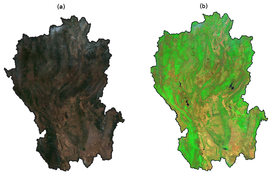
The objective of this study was analyzed and generated burned areas mapping by using SENTINEL-2 satellite imagery over seventeen provinces in the Northern Thailand. The two indices were used for conducting to calculate with the Google Earth Engine platform. It consisted of the Normalized Burn Ratio (NBR) and the Normalized Difference Vegetation Index (NDVI) which can be extracted the frequency distribution of burned areas. The results found that both indices effectively distinguished between burned and non-burned areas. The establishment threshold values to extract burned areas used the statistical analysis to set threshold values with the maximum and minimum values couple with the one standard deviation range. The results were consistent with burned areas derived from visual analysis (False color composite; FCC) and were also in agreement with reference data, with an overall accuracy and kappa coefficient of 66.80 and 33.59 percent, respectively. In addition, validation with the index value obtained from the Satellite image time series and false color composite can be applied to study the pattern of burning in the area to inform about the timeframe and duration of a burn.
References
Arruda, L.S. V., Piontekowski, J. V., Alencar, A., Reginaldo, S. P. and Matricardi, A.T. E. (2021). An alternative approach for mapping burn scars using Landsat imagery, Google Earth Engine, and Deep Learning in the Brazilian Savanna. Remote Sensing Applications: Society and Environment, 22.
Chuvieco, E., Mouillot, F., Werf, R. G., Miguel, S., Tanase, M., Koutsias, N., García, M., Yebra, M., Padilla, M., Gitas, I., Heil, A., Hawbaker, J. T. and Giglio, L. (2019). Historical background and current developments for mapping burned area from satellite Earth observation. Remote Sensing of Environment, 225, 45-64.
Department of Disaster Prevention and Mitigation. (2015). This National disaster Risk Management Plan.
Gorelick, N., Hancher, M., Dixon, M., Ilyushchenko, S., Thau, D. and Moore, R. (2017). Google Earth Engine: Planetary-scale geospatial analysis for everyone. Remote Sensing of Environment, 202, 18-27.
Key, C., Benson, N., (1999). The Normalized Burned Ratio, a Landsat TM radiometric index of burn severity incorporating multi-temporal differencing. (http://nrmsc.usgs.gov/research/nbr.htm).
Lins, F. K. (1981). Comparison of Sampling Procedures and Data Analysis for a Land-Use and Land-Cover Map. Photogrammetric Engineering & Remote Sensing, 47(3), 343-351.
Pinto, M.M., Trigo, R.M., Trigo, I.F. and DaCamara, C.C. (2021). A Practical Method for High-Resolution Burned Area Monitoring Using Sentinel-2 and VIIRS. Remote Sensing, 13.
Rouse, J. W., Jr., Haas, R. H., Schell, J. A. and Deering, D. W. (1974). Monitoring Vegetation Systems in The Great Plains with ERTS. Proceedings of the Third Earth Resources Technology Satellite-1 Symposium, Washington, D.C.
Volcani, A., Karnieli, A. and Svoray, T. (2005). The use of remote sensing and GIS for spatio-temporal analysis of the physiological state of a semi-arid forest with respect to drought years. Forest Ecology and Management, 215, 239-250.
ธนพล ขำเรืองวงศ์ และ ดรุณวรรณ กำธรเกียรติ. (2564). ดัชนีเผาไหม้จากภาพถ่ายดาวเทียม Landsat 8 และข้อจำกัดการใช้งาน. วิทยาศาสตร์บูรพาม 26(2), 1308-1325.
นวพล ลินต๋า, นัฐพล มหาวิค, ศศิธร ฉัตรสุดารัตน์, กมลฉัตร ศรีจะตะ และ อภิษฐา ยอดยิ่ง. (2564). การวิเคราะห์พื้นที่เผาไหม้จากไฟป่าด้วยภาพดาวเทียม Sentinel-2 กรณีศึกษา อำเภอปาย จังหวัดแม่ฮ่องสอน. วารสารวิทยาการสารสนเทศและเทคโนโลยีประยุกต์, 3(2), 101-121.
พงศ์พันธุ์ จันทะคัต, เยาวเรศ จันทะคัต และ จอมภัค จันทะคัต. (2565). การเฝ้าติดตามไฟป่าแบบใกล้เวลาจริงด้วยกูเกิลเอิร์ธเอนจิน กรณีศึกษา อำเภอปาย จังหวัดแม่ฮ่องสอน. วารสารวิทยาศาสตร์และเทคโนโลยีนายเรืออากาศ, 18(1), 1-14.
สุภาสพงษ์ รู้ทำนอง. (2562). การสกัดและประเมินพื้นที่ถูกเผาไหม้โดยใช้ค่าความแตกต่างของดัชนีเชิงคลื่นหลายช่วงเวลา จากข้อมูลแลนด์แซท 8 : กรณีศึกษา อุทยานแห่งชาติคลองวังเจ้า คลองลาน และแม่วงก์. สักทอง:วารสารมนุษยศาสตร์และสังคมศาสตร์, 25(2), 49-65.
สุรีรัตน์ คนเพียร, จตุรงค์ สมอาจ, วรวิทย์ จิตรสุขขา และ สาวิตรี รตโนภาส สุวรรณลี. (2562). การตรวจวัดพื้นที่ฟื้นฟูไฟป่าเขตอนุรักษ์ในพื้นที่จังหวัดเลย ด้วยข้อมูลภาพถ่ายจากดาวเทียม LANDSAT หลายช่วงเวลา. วารสารวิทยาศาสตร์และเทคโนโลยี, 28(7), 1185-1201.
อนุเผ่า อบแพทย์, ภูภัส ทองจับ, วันสิริ สุกสีนวล, และ อาทิตยา ยีบ๊ะ. (2564). การวิเคราะห์ค่าความรุนแรงพื้นที่เผาไหม้จากภาพถ่ายดาวเทียม Sentinel-2 กรณีศึกษาอุทยานแห่งชาติดอยสุเทพ-ปุย. การประชุมวิชาการวิศวกรรมโยธาแห่งชาติ ครั้งที่ 26, วันที่ 23-25 มิถุนายน 2564 . การประชุมรูปแบบออนไลน์.