Landscape Structure of Green Spaces and Its Effect on Land Surface Temperature in Chiang Rai City Area, Thailand
Keywords:
Landscape Structure, Landscape Measures, Green Area, Surface TemperatureAbstract
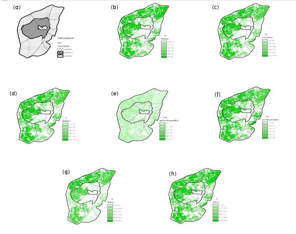
The research of this study aimed to 1) to study the landscape structure of the green area and 2) to analyze the impact of the urban heat island phenomenon in the urban area of Chiang Rai. The landscape structure of the green area can be described and examined by landscape measures assessed from the structural characteristics i.e. 1) size, 2) shape, and 3) core of the green patch. In this study, these measures were calculated through the QGIS 2.8 program using the LECOS-FRAGSTATS Tool. Landsat 8-TIRS, recorded on 9 March 2021, is an important parameter
in determining the urban heat island effect in Chiang Rai. The measures were selected through multiple regression analysis. The results show that measures of structural characteristics such as crack/crack size of the green area can significantly reduce the mean surface temperature. Also included were the core index and border sum metrics, with a decision coefficient (R2) of 0.174. Green space in urban green infrastructure planning and urban climate improvement Chiang Rai next word.
References
กรมการปกครอง. (2561). ส่วนบริหารและพัฒนาเทคโนโลยีการทะเบียนสำนัก บริหารการทะเบียน เรื่อง สถิติจำนวนประชากรและบ้าน. สืบค้นจาก https://stat.bora.dopa.go.th/stat/statnew/statMONTH/statmonth/#/mainpage
กรมอุตุนิยมวิทยา. (2561). ศูนย์ภูมิอากาศและกองพัฒนาอุตุนิยมวิทยา เรื่อง สถิติอุณหภูมิสูงที่สุดในช่วงฤดูร้อนของประเทศไทยระหว่างพ.ศ. 2494 - 2565. สืบค้นจาก https://www.tmd.go.th/climate/tempmaxstatlatest
ชมพูนุท คงพุนพิน, มานัส ศรีวณิช และภาวิณี เอี่ยมตระกูล. (2560). การประเมินศักยภาพพื้นที่สีเขียวเพื่อการวางแผนการใช้ที่ดินอย่างยั่งยืนในจังหวัดนครนายก. การประชุมวิชาการ ทรัพยากรธรรมชาติ สารสนเทศภูมิศาสตร์ และสิ่งแวดล้อม ครั้งที่ 2 (NatGen 2nd), วันที่ 15 ธันวาคม 2560 (น. 101-104). พิษณุโลก: ภาควิชาทรัพยากรธรรมชาติและสิ่งแวดล้อมคณะเกษตรศาสตร์ ทรัพยากรธรรมชาติและสิ่งแวดล้อม มหาวิทยาลัยนเรศวร.
มานัส ศรีวณิช. (2565). การประยุกต์ใช้ภูมิสารสนเทศการวิเคราะห์ในเมืองการวางแผนสิ่งแวดล้อมและพื้นที่สีเขียว. [เอกสาร ประกอบการสอน]. กรุงเทพฯ: คณะสถาปัตยกรรมศาสตร์และการผังเมือง มหาวิทยาลัยธรรมศาสตร์.
Chena A, Yaoc XA, Suna R, & Chena L. (2012). Effect of urban green patterns on surface urban cool islands and its seasonal variations. Urban Forestry & Urban Greening. Environmental Science, 11(2), 646–654. Retrieved from: https://www.semanticscholar.org/paper/ffect-of-urban-green-patterns-on-surface-urban-cool-Chena-Yaoc/69b6cf05113ea32cb1388f4235e8e810cecaea18
McGarigal K, Cushman S, & Ene E. (2012). FRAGSTATS v4: Spatial Pattern Analysis Program for Categorical and Continuous. Computer software program produced by the authors at the University of Massachusetts. Retrieved from: http://www.umass.edu/landeco/research/fragstats/fragstats.html