Application of Geographic Information System for Mapping Historical Meteorological Droughts in Phayao Province
Keywords:
Geographic Information System, Historic Drought Map, Spatial DatabaseAbstract
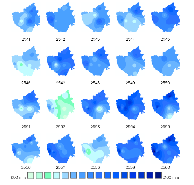
The objective of this study was to generate the distribution maps of annual rainfall and meteorological drought intensity within Phayao province during 1988-2017. Study area was divided into grid cells at 30-meter spatial resolution. Spatial interpolation technique of Inverse distance weighted (IDW) was used for annual rainfall estimation at ungauged locations or grid cells. The annual rainfall maps were stored and displayed as a raster data layer. Raster calculator tool of geogra phic information system software was used for converting the annual rainfall maps to meteorological drought intensity maps. The result showed also that the procedure was possible and utilized as support data for studying historical meteorological droughts.
References
กีรติ ลีวัจนกุล. (2543). อุทกวิทยา. ปทุมธานี: มหาวิทยาลัยรังสิต.
ฐาปนีย์ มีชำนาญ, ธเนศร์ สมบูรณ์ และ วิษุวัฒก์ แต้สมบัติ. (2561). การประเมินเทคนิคการประมาณค่าฝนร่วมกับข้อมูลแผนที่ภูมิประเทศเชิงตัวเลขในลุ่มน้ำตาปี. วารสารวิศวกรรมศาสตร์, 13(2), 144-152.
ณัฐกานต์ ภูมิโคกรักษ์, นลินขวัญ จันทร์เสงี่ยม, ชนิษฐา มะลิลา, รุ่งฤดี เจนรอบ, นัทธมน เชาว์ภาษี, นิสาลักษณ์ วังสุข, และ สมกมล รักวีรธรรม. (2564). การศึกษาความรุนแรงของความแห้งแล้งทางอุตุนิยมวิทยาในพื้นที่ภาคเหนือ ประเทศไทยด้วยดัชนีความแห้งแล้งทางอุตุนิยมวิทยา ระหว่างช่วงปี พ.ศ.2530-2562.
การประชุมวิชาการระดับชาติ “ทรัพยากรธรรมชาติ สารสนเทศภูมิศาสตร์ และสิ่งแวดล้อม ครั้งที่ 5” (698-710). มหาสารคาม: คณะวิทยาการสารสนเทศ มหาวิทยาลัยมหาสารคาม.
เทวินทร์ โจมทา. (2550). การศึกษาแบบจำลองดัชนีความแห้งแล้งทางอุตุนิยมวิทยาในพื้นที่ประสบภัยแล้งบริเวณภาคตะวันออกเฉียงเหนือของประเทศไทย. กรุงเทพฯ: กรมอุตุนิยมวิทยา.
ธิติยา ศรีนาราง และ รังสรรค์ เกตุอ๊อต. (2563). การประเมินฝุ่นละอองขนาดเล็กกว่า 10 ไมครอนด้วยวิธีประมาณค่าเชิงพื้นที่ในบริเวณภาคเหนือของประเทศไทย. วารสารวิชาการเพื่อการพัฒนานวัตกรรมเชิงพื้นที่, 1(2), 35-47.
วิภพ แพงวังทอง. (2549). การประยุกต์ใช้ข้อมูลดาวเทียมและระบบสารสนเทศภูมิศาสตร์ เพื่อการวิเคราะห์พื้นที่เสี่ยงต่อความแห้งแล้ง ในอำเภอบ้านด่านลานหอย จังหวัดสุโขทัย (วิทยานิพนธ์มหาบัณฑิต). มหาวิทยาลัยนเรศวร, พิษณุโลก.
ศูนย์เตือนภัยพิบัติแห่งชาติ. (2022). รู้จักภัยจาก ภัยแล้ง (Droughts). สืบค้นจาก http://ndwc.disaster.go.th/cmsdetail.ndwc-9.283/26675/menu_7525/4214.3/รู้จักภัยจากภัยแล้ง (Droughts).
ศูนย์ภูมิภาคเทคโนโลยีอวกาศและภูมิสารสนเทศ ภาคตะวันออกเฉียงเหนือ. (ม.ป.ป). ระบบสารสนเทศพื้นที่เสี่ยงภัยแล้ง Drought Information System. สืบค้นจาก https://negistda.kku.ac.th/drought/ed_method.htm.
ศูนย์อุทกวิทยาชลประทานภาคเหนือตอนบน. (2564). สภาพน้ำฝน. สืบค้นจาก https://www.hydro-1.net
สวัสดิ์ โนนสูง. (2546). ทรัพยากรธรรมชาติและสิ่งแวดล้อม (พิมพ์ครั้งที่ 2). กรุงเทพฯ: โอเดียนสโตร์.
สำนักข่าว กรมประชาสัมพันธ์. (2564). จังหวัดแพร่ถอดบทเรียนปี 2564 เตรียมพร้อมรับสถานการณ์ภัยแล้งปี 2565. สืบค้นจาก https://thainews.prd.go.th/th/news/detail/TCATG211226133904869.
สุทัศน์ ยกส้าน. (2561). Sahara กับทะเลทราย Dasht-e Lut ที่ร้อนที่สุดในโลก. MGR ONLINE.
American Geophysical Union. (1999). Sahara's Abrupt Desertification Started by Changes In Earth's Orbit, Accelerated By Atmospheric And Vegetation Feedbacks. ScienceDaily. Retrieved from www.sciencedaily.com/releases/1999/07/990712080500.htm.
DeMenocal, P. B., & Tierney, J. E. (2012). Green Sahara: African humid periods paced by Earth’s orbital changes. Nature Education Knowledge, 3(10), 12.
Nature Education. (2012). Green Sahara: African Humid Periods Paced by Earth's Orbital Changes. Retrieved from: https://www.nature.com/scitable/knowledge/library/green-sahara-african-humid-periods -paced-by-82884405/
Post Today. (2560). ซาฮาราเคยเป็นพื้นที่เขียวชอุ่ม และแห้งแล้งโดยน้ำมือมนุษย์. Retrieved from: https://www.posttoday.com/world/486087
Retrieved from https://mgronline.com/science/detail/9610000067372.
ScienceDaily [Internet]. 2022; Accessed 2022 August 10. Retrieved from: https://www.posttoday.com/world/486087.
Subramanya K. (2008). Hydrology (3rd ed.). New Delhi: Tata McGraw-Hill Publishing Company Limited.
Wichitarapongsakun, P. (2016). Meteorological drought in the Sakea Krang River basin using the Standardized Precipitation Index (SPI) and the Meteorological Drought Index (D)/การวิเคราะห์ระดับความแห้งแล้งทาง อุตุนิยมวิทยาในพื้นที่ลุ่มน้ำสะแกกรังด้วยดัชนีน้ำฝนมาตรฐาน และดัชนีความแห้งแล้งทางอุตุนิยมวิทยา. Naresuan University Journal: Science and Technology (NUJST), 24(3), 123-135.