Evaluation of The Effect of Road Lighting System on Rice Cultivation Using Geoinformatics
Keywords:
Digital Image Processing, Artificial night light, Light pollution, Rice phenologyAbstract
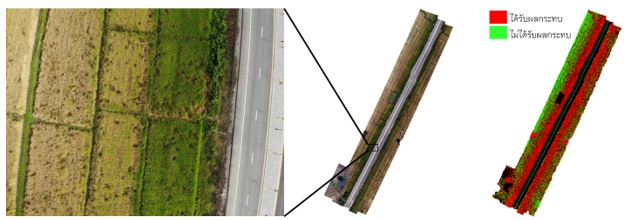
This paper aims to analyze and assess the effect of the road lighting system on rice cultivation besides the Upali (Upalighunupamachan) Road, located in Dok Khamtai district, Phayao province, between 2018 and 2021. Rice phenology was created by fusing the Normalized Difference Vegetation Index (NDVI), derived from Sentinel-2 satellite imagery, with the time series analysis to monitor rice cultivation and to assess the effect of road lighting systems on the rice growth. A spatial impact assessment was conducted using an unsupervised UAV orthophoto classification. The result shows that the artificial night light delays the flowering time in rice cultivation, and it can be affected up to 50 meters from the road’s centerline or 40 meters from the shoulder. There are farmers' problems in planting, harvesting, and management. This valuable information can help farmers and stakeholders to design the solution based on facts and empirical evidence.
References
กมลินทร์ พรหมรัตน์รักษ์, ลิลลี่ กาวีต๊ะ, มาลี ณ นคร และ รังสฤษดิ์ กาวีต๊ะ. (2548). อิทธิพลของช่วงแสงต่อการเปลี่ยนแปลงทางสัณฐานของปลายยอดข้าว. การประชุมทางวิชาการของมหาวิทยาลัยเกษตรศาสตร์ ครั้งที่ 43: สาขาพืช (น. 491-498). กรุงเทพฯ: สำนักงานกองทุนสนับสนุนการวิจัย มหาวิทยาลัยเกษตรศาสตร์.
กรมทางหลวง. (2554). ข้อกำหนดมาตรฐานงานทั่วไปงานติดตั้งไฟฟ้าส่องสว่างบนทางหลวง. สืบค้นจาก https://www.yotathai.com/yotanews/lighting-installation.
สมาคมผู้ส่งออกข้าวไทย. (2565). ผลพยากรณ์การผลิตข้าว. สืบค้นจาก http://www.thairiceexporters.or.th/ production.htm.
สำนักงานประชาสัมพันธ์. (2563). แขวงทางหลวงชนบทจังหวัดพะเยาพร้อมเปิดใช้งานถนนอุบาลี (พระอุบาลีคุณูปมาจารย์). สืบค้นจาก https://region3.prd.go.th/region3_ci/topic/news/14931.
สำนักงานเศรษฐกิจการเกษตร. (2565). สถิติการส่งออก (Export). สืบค้นจาก http://impexp.oae.go.th/service/export.phpS_YEAR=2564&E_YEAR=2564&PRODUCT_GROUP=5250&wf_search=&WF_SEARCH=Y.
สำนักงานสถิติแห่งชาติ. (2553). รายงานวิเคราะห์สถานการณ์จังหวัดพะเยา. สืบค้นจาก http://osthailand.nic.go.th/masterplan_area/userfiles/fileDownload/Report Analysis Province/รายงานวิเคราะห์สถานการณ์จังหวัดพะเยา.pdf.
สำนักประชาสัมพันธ์พะเยา. (2563). เกษตรกรผู้ปลูกข้าวตำบลจำป่าหวาย อ.เมืองพะเยา ร้องข้าวไม่ออกรวง จากผลกระทบไฟส่องสว่างบนถนน ด้านหน่วยงานที่เกี่ยวข้องลงพื้นที่แก้ไขปัญหา. สืบค้นจาก https://thainews.prd.go.th/th/news/detail/TCATG201027151715239.
Betancourt, M. & Zaira, M-R. (2018). Normalized difference vegetation index for rice management in El Espinal, Colombia. DYNA, 85, 47-56.
Bhandari, A.K., Kumar, A., & Singh, G.K. (2012). Feature Extraction using Normalized Difference Vegetation Index (NDVI): A Case Study of Jabalpur City. Procedia Technology, 6(2012), 612-621.
Chen, C.,Huang, M., Lin, K., Wong, S., Huang, W. & Yang, C. (2014). Effects of Light Quality on the Growth, Development and Metabolism of Rice Seedlings (Oryza sativa L.). Research Journal of Biotechnology, 9, 15-24.
Chen, J., Jönsson, P., Tamura, M., Gu, Z., Matsushita, B., & Eklundh, L. (2004). A simple method for reconstructing a high-quality NDVI time-series data set based on the Savitzky–Golay filter. Remote Sensing of Environment, 91(3–4).
Chen, Y., Cao, R., Chen, J., Liu, L., & Matsushita, B. (2021). A practical approach to reconstruct high-quality Landsat NDVI time-series data by gap filling and the Savitzky–Golay filter. ISPRS Journal of Photogrammetry and Remote Sensing, 180, 174-190.
Chepesiuk R. (2009). Missing the dark: health effects of light pollution. Environmental health perspectives. 117(1), A20–A27.
de Lima, I. P., Jorge, R. G., & de Lima, J. L. P. (2021). Remote sensing monitoring of rice fields: Towards assessing water saving irrigation management practices. Frontiers in Remote Sensing, 2, 762093.
Jeevalakshmi, D., Reddy, S. N., & Manikiam, B. (2016). Land cover classification based on NDVI using LANDSAT8 time series: A case study Tirupati region. In 2016 International Conference on Communication and Signal Processing (ICCSP) (pp. 1332-1335). IEEE.
Kurahara, Y., & Itsubo, N. (2022). Quantitative Environmental Impact Assessment for Agricultural Products Caused by Exposure of Artificial Light at Night. In Z. S. Klos, J. Kalkowska, & J. Kasprzak (Eds.), Towards a Sustainable Future - Life Cycle Management: Challenges and Prospects (pp. 27-38). Cham: Springer International Publishing.
Meeragandhi, G., bS.Parthiban, & A, cNagaraj. (2015). Ndvi: Vegetation change detection using remote sensing and gis – A case study of Vellore District. Procedia Computer Science, 57(2015), 1199 – 1210.
Pohl, C. & gendersen, J. V. (2017). Remote Sensing Image Fusion : A Practical Guide. Boca Raton: CRC Press.
Rosle, R., Che’Ya, N. N., Roslin, N. A., Halip, R. M., & Ismail, M. R. (2019). Monitoring early stage of rice crops growth using normalized difference vegetation index generated from UAV. In IOP Conference Series: Earth and Environmental Science (Vol. 355, No. 1, p. 012066). IOP Publishing.
Shih, H-c., Stow, D. A., Weeks, J. R., & Coulter, L. L. (2016). Determining the Type and Starting Time of Land Cover and Land Use Change in Southern Ghana Based on Discrete Analysis of Dense Landsat Image Time Series. IEEE Journal of Selected Topics in Applied Earth Observations and Remote Sensing, 9(5), 2064-2073.
Wijesingha, J. S. J., Deshapriya, N. L., & Samarakoon, L. (2015). RICE CROP MONITORING AND YIELD ASSESSMENT WITH MODIS 250m GRIDDED VEGETATION PRODUCT: A case study in Sa Kaeo Province, Thailand. International Archives of the Photogrammetry, Remote Sensing & Spatial Information Sciences.