Accuracy Assessment of Map Coordinates from Unmanned Aerial Vehicle
Keywords:
ground surveying, unmanned aerial vehicle, three dimensions coordinateAbstract
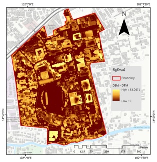
Unmanned aerial vehicle (UAV) surveying and mapping data have not yet been clearly defined as a positional accuracy standard. Therefore, this study verifies the three-dimensional coordinates' accuracy from the UAV data. The objective was to assess the accuracy of the three-dimensional coordinates of the UAV map using theodolite survey data. The horizontal and vertical coordinates of the theodolite were obtained by closed-loop surveying and trigonometry, respectively, while the horizontal and vertical coordinates of the UAV were obtained from orthophotograph and the difference between the DSM and DTM data, respectively. The estimation of the accuracy of the three-dimensional coordinates consisted of the horizontal (X and Y) and vertical (Z) position accuracy. As a result, it was found that the RMSE of X and Y coordinates was 1.22 and 3.44, respectively, and the NSSDA standard error of horizontal accuracy was about 3.65 meters. On the other hand, The RMSE of Z value between the blueprint height and the theodolite measurement height was 1.19, and the NSSDA standard error of vertical accuracy was about 2.34 meters. The RMSE of Z value between the blueprint height and object height from the UAV was 4.19, and the NSSDA standard error was about 8.21 meters. In conclusion, the selection of horizontal position data was performed with either of the two survey methods depending on the acceptable accuracy. The ground survey data was high vertical positions more accurate than UAV. However, buildings with low heights (lower than 10 meters) can use both theodolite and UAV surveys.
References
กรมโยธาธิการและผังเมือง. (2564). การสำรวจและจัดทำแผนที่ด้วยอากาศยานไร้คนขับ (Unmanned Aerial Vehicle: UAV). สืบค้นจาก http://oldoffice.dpt.go.th/km/images/pdf/paper_km_6_63.pdf.
กัญญารัตน์ วัลภา. (2564). การรับรู้ระยะไกล (Remote Sensing). สืบค้นจาก http://gungunyarat. blogspot.com.
กาญจน์เขจร ชูชีพ. (2561). การประเมินความถูกต้อง (Accuracy Assessment): Remote Sensing Technical. Note NO.3 (2018). Faculty of Forestry, Kasetsart University.
จนิษฐ์ ประเสริฐบูรณะกุล, วิลาสลักษณ์ วงศ์เยาว์ฟ้า และ สุกิจ วิเศษสินธุ์. (2561). การวิเคราะห์พื้นที่น้ำท่วมด้วย LIDAR: ข้อมูลความสูงภูมิประเทศเชิงเลขความละเอียดสูง. กรุงเทพฯ: บริษัท ESRI (ประเทศไทย) จำกัด.
นภสัวรรณ บุญทวีสวัสดิ์. (2562). ความถูกต้องเชิงพื้นที่ของการใช้อากาศยานไร้คนขับเพื่อผลิตแผนที่ภาพถ่ายรายละเอียดสูง (Spatial accuracy of applying unmanned aerial vehicle to produce high – resolution map) (บัณฑิตวิทยาลัย), มหาวิทยาลัยศรีนครินทรวิโรฒ, กรุงเทพฯ.
มานัส ยอดธง. (2564). การหาความสูงของวัตถุด้วยกล้องวัดมุม [เอกสารประกอบการสอน]. ขอนแก่น: สาขาวิชาช่างสำรวจ, วิทยาลัยเทคนิคขอนแก่น.
วิศวกรรมสถานแห่งประเทศไทย. (2562). มาตรฐานการสำรวจด้วยอากาศยานไร้คนขับเพื่องานวิศวกรรม (ฉบับเทคนิคพิจารณ์). สืบค้นจาก https://onedrive.live.com/?authkey=%21ALmUKv3xryMXbMo&cid=46DDF7F825C74B24&id=46DDF7F825C74B24%211028&parId=46DDF7F825C74B24%211027&o=OneUp.
สมบัติ อยู่เมือง. (2564). ข้อมูลจากการสำรวจระยะไกล (Remote Sensing). สืบค้นจาก http://www.gisthai.org / about-gis/remote-sensing.html.
สำนักงานพัฒนาเทคโนโลยีอวกาศและภูมิสารสนเทศ (องค์การมหาชน). (2555). ความหมายของข้อมูลความสูงภูมิประเทศที่ให้บริการ การเผยแพร่และบริการข้อมูลภูมิสารสนเทศพื้นฐาน ชั้นข้อมูลความสูงภูมิประเทศ (DEM). กรุงเทพฯ: สำนักงานคณะกรรมการยุทธศาสตร์เพื่อวางระบบวางบริหารจัดการทรัพยากรน้ำ (กยน.).
สิทธิพร พันธุระ. (2558). รายวิชาวิศวกรรมสำรวจ (Survey Engineering) [เอกสารประกอบการสอน]. อุดรธานี: สาขาวิชาเทคโนโลยีก่อสร้าง, คณะเทคโนโลยี, มหาวิทยาลัยราชภัฏอุดรธานี.
Authority, T. V. (1998). Geospatial Positioning Accuracy Standards Part 3: National Standard for Spatial Data Accuracy. National Aeronautics and Space Administration: Virginia, NV, USA.