Application of Geographic Information System via Web for Class of Local Resource and Environmental Management
Keywords:
Geographic Information System via Web, General Education, Local Resource and Environmental ManagementAbstract
The objective is to apply Geographic Information System (GIS) via web for teaching subject named Local Resource and Environmental Management under General Education (GE) of Rajamangala University of Technology ISAN (RMUTI). The research named Biodiversity Assessment of Forest Area based on Geo-information in Nongrawiang Center of RMUTI, is developed by rapid prototype model. Method included 3 steps: (1) modelling prototype from such mentioned research with improvement in step 1-5 and 10-12, (2) development and testing of GIS via web based on Windows 10, GeoServer, uDig, PostgreSQL, AppServ, Notepad++ and Black box testing and (3) evaluation-based the 1ST RMUTI student in academic year 2019. This evaluation used sample size 356 students and surveyed by simple random sampling with questionnaire during January 1 to March 31, 2019.
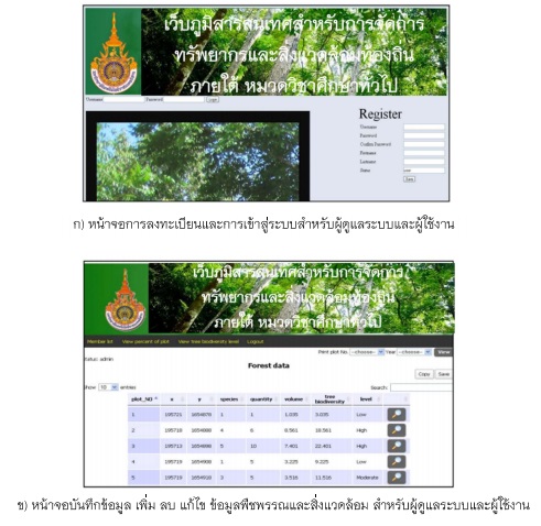
As results, this GIS via web is developed and improved in term of web name, level of accessibility, adding functions for study area and plant composition and database linkage for collecting spatial data in Cloud GIS. In this regard, the benefits of the new web system will receive tree information in area of RMUTI center in order to manage trees and green areas in accordance with RMUTI's green university policy. In result of the evaluation, it founded that, this web is in moderate satisfaction level with average 3.11. The most satisfaction level is comfortable and easy for login (average 3.55) while the least of average is speed of display (average 2.73). Consequently, this developed web GIS is implemented for teaching but this web should be improved by increasing the speed of rendering, techniques to improve data service efficiency with standards of Web Map Tile Service (WMTS) and indexing for database.