Application of Geographic Information System for Assessing Drought Risk Areas in Sisaket Province
Keywords:
Drought, Risk Area, Geographic Information SystemAbstract
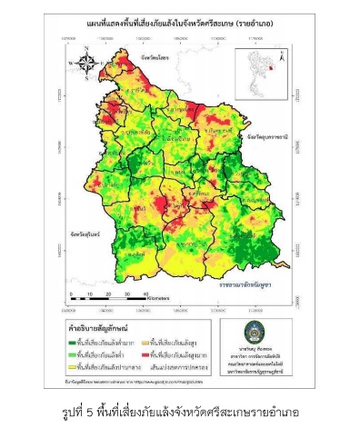
This research is to study the drought in Sisaket province where is strongly affected every year. As an effect, the people have suffered such as lack of water for consumption and agriculture that lead to impact on the provincial economic. The researcher therefore recognizes the problem and applies GIS to analyze the drought risk areas in Sisaket province. The objectives are: 1) to study the factors affecting drought in Si Sisaket province, 2) to assess drought risk areas and 3) to propose the solutions for drought problems in Sisaket province. The collection of drought statistics and the factors affecting the drought in Sisaket province is addressed to classify the risk areas by using Potential Surface Analysis (PSA). The results show that the most influential factor affecting drought in Sisaket province is average rainfall for the past 10 years. According to overlapping all factors and dividing the drought risk areas in Sisaket province, the study indicates that the highest risk areas of drought are Yang Chum Noi, Sila Lat and Mueang Chan. The high-level areas are Phrai Bueng, Rasri Salai, and Rattana. The least drought risk areas are Non Koon Nam, Kliang and Kantharalak.