Land Use Predictions using CLUmondo Model: A Case Study of Muang District, Chiang Mai Province
Keywords:
land use, physical factors, CLUmondo modelAbstract
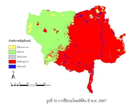
This study aimed to analyze the land use change in order to create spatial land use change model by using CLUmondo model and to predict land use change in the future in Muang District, Chiang Mai Province. This land use change model used data from the Land Development Department in 2006 and 2015. Land use was classified into 5 classes agricultural, forest, urban area, water body and miscellaneous. The 7 physical factors data, including stream, dem, slope, rain, village, road and soil were also considered. According to the simulation of land use change to the year 2024 by using simulations of events from past land use trends, the findings revealed that urban area was 119,014 rai or 61.20 percent of total area, forest was 65,580 rai or 33.73 percent of total area, agricultural was 4,817 rai or 2.48 percent of total area, water body was 3,227 rai or 1.66 percent of total area. and miscellaneous was 1,817 rai or 0.93 percent of total area respectively.