
Application of the HEC-HMS model for analysing land use change and hydrological responses across different return periods in tropical flood-prone areas
Article Sidebar
Main Article Content
Abstract
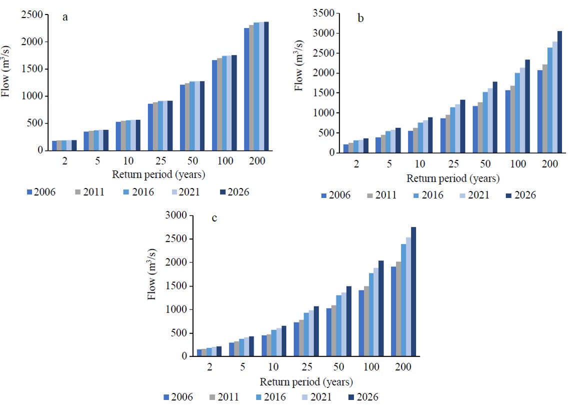
Land use change is a significant environmental concern worldwide today, as it has the potential to increase the frequency of natural disasters, such as floods. The Sg. Segamat Watershed, which is particularly vulnerable to flooding, highlights the importance of hydrological modelling as a crucial tool in disaster mitigation. In this study, the Hydrologic Engineering Center’s Hydrologic Modelling System (HEC-HMS) was utilised to assess the effects of land use change on hydrological responses across various return periods. The analysis examined both the pre- and post-calibration phases under varying land use conditions. Land use data from 2006 and 2011 were used to simulate future scenarios. The findings showed that the expansion of built-up areas and the conversion of forested land to mixed agriculture had a significant influence on flood patterns. Specifically, built-up areas expanded by 2.24%, resulting in increased flood volumes in sub-basins 4, 9, and 12 between 2006 and 2026. Concurrently, forest cover declined by approximately 4.40%, which led to heightened flood peak heights in sub-basins 1, 3, and 11 under all land use conditions. Sub-basin 3 recorded the highest flood peak height, estimated at 1,150.20 m³/s in the pre-calibration phase, 1,165.80 m³/s in the post-calibration, and 1,036.20 m³/s using the initial CN with calibrated parameters. Meanwhile, sub-basin 4 demonstrated the highest flood volume, with estimates reaching 342.10 mm pre-calibration, 366.09 mm post-calibration, and 341.04 mm using initial CN with calibrated parameters. These results clearly demonstrate how land use changes influence hydrological behaviour, emphasising the need for watershed planning and flood risk management. The study highlights the value of hydrological modelling as a tool for enhancing flood mitigation strategies and provides crucial insights for policymakers, planners, government agencies, and local communities.
Article Details

This work is licensed under a Creative Commons Attribution-NonCommercial-NoDerivatives 4.0 International License.

This work is licensed under a Creative Commons Attribution-NonCommercial-NoDerivatives 4.0 International License.
References
Makwana N. Disaster and its impact on mental health: a narrative review. J Family Med Prim Care. 2019;8(10):3090-5.
Swain KC, Singha C, Nayak L. Flood susceptibility mapping through the GIS-AHP technique using the cloud. ISPRS Int J Geo-Inf. 2020;9(12):720.
Glago FJ. Flood disaster hazards; causes, impacts and management: a state-of-the-art review. In: Farsangi EN, editor. London: Intech Open; 2021: p. 1-19.
Centre for Research on the Epidemiology of Disasters (CRED). Disaster year in review 2020: Global trends and perspectives. Cred Crunch, 62. [Internet]. 2021 [cited 2023 Apr 7]. Available from: https://reliefweb.int/report/world/cred-crunch-newsletter-issue-no-62-may-2021-disaster-year-review-2020-global-trends-and.
Centre for Research on the Epidemiology of Disasters (CRED). The human cost of disasters - an overview of the last 20 years 2000-2019 [Internet]. 2020 [cited 2023 Apr 7]. Available from: https://reliefweb.int/report/world/human-cost-disasters-overview-last-20-years-2000-2019.
Nguyen HD, Fox D, Dang DK, Pham LT, Viet Du QV, Nguyen THT, et al. Predicting future urban flood risk using land change and hydraulic modeling in a river watershed in the central province of Vietnam. Remote Sens. 2021;13(2):262.
Tabari H. Climate change impact on flood and extreme precipitation increases with water availability. Sci Rep. 2020;10:13768.
Tan ML, Gassman PW, Yang X, Haywood J. A review of SWAT applications, performance and future needs for simulation of hydro-climatic extremes. Adv Water Resour. 2020;143:103662.
Camara M, Jamil NRB, Abdullah AFB, Hashim RB. Integrating cellular automata Markov model to simulate future land use change of a tropical basin. Glob J Environ Sci Manag. 2020;6(3):403-14.
Safiah Yusmah MY, Bracken LJ, Sahdan Z, Norhaslina H, Melasutra MD, Ghaffarianhoseini A, et al. Understanding urban flood vulnerability and resilience: a case study of Kuantan, Pahang, Malaysia. Nat Hazards. 2020;101(2):551-71.
Al-Hussein AAM, Khan S, Ncibi K, Hamdi N, Hamed Y. Flood analysis using HEC-RAS and HEC-HMS: a case study of Khazir River (Middle East—Northern Iraq). Water. 2022;14(22):3779.
D'Ayala D, Wang K, Yan Y, Smith H, Massam A, Filipova V, et al. Flood vulnerability and risk assessment of urban traditional buildings in a heritage district of Kuala Lumpur, Malaysia. Nat Hazards Earth Syst Sci. 2020;20(8):2221-41.
Zawiah WZW, Jemain AA, Ibrahim K, Suhaila J, Sayang MD. A comparative study of extreme rainfall in Peninsular Malaysia: with reference to partial duration and annual extreme series. Sains Malaysiana. 2009;38(5):751-60.
Rosmadi HS, Ahmed MF, Mokhtar MB, Lim CK. Reviewing challenges of flood risk management in Malaysia. Water. 2023; 15(13):2390.
Mohamad S, Ash’aari ZH, Ramli MF, Abdullah R, Rehan BM. Application of a hybrid Cellular Automaton-Markov Model in land use change detection and prediction in flood-prone area, Johor, Malaysia. Planning Malaysia. 2023;21(6):170-84.
Garg V, Nikam BR, Thakur PK, Aggarwal SP, Gupta PK, Srivastav SK. Human-induced land use land cover change and its impact on hydrology. HydroResearch. 2019;1:48-56.
Thoufil Ali MS, Chandran D. Impact of land use land cover change on runoff in Kuttiyadi River Basin. Int J Eng ResTechnol. 2022;11(7):390-403.
Newman G, Kim Y, Joshi K, Liu J. Integrating prediction and performance models into scenario-based resilient community design. J Digit Landsc Archit. 2020;5:510-20.
Ajjur SB, Al-Ghamdi SG. Exploring urban growth–climate change–flood risk nexus in fast growing cities. Sci Rep. 2022;12(1): 12265.
Xin Z, Shi K, Wu C, Wang L, Ye L. Applicability of hydrological models for flash flood simulation in small catchments of hilly area in China. Open Geosci. 2019;11(1):1168-81.
Sharu EH. Development of HEC-HMS model for flow simulation at Dungun River Basin Malaysia. Adv Agric Food Res J. 2021;2(1):a0000169.
El Yousfi Y, Himi M, El Ouarghi H, Aqnouy M, Benyoussef S, Gueddari H, et al. GIS preprocessing for rainfall-runoff modeling using HEC-HMS in Nekkor watershed (Al-Hoceima, Northern Morocco). E3S Web Conf. 2023;364:01005.
Al-Samawi I, Noman A, Khanbari K, Quriaa H, Al-Areeq N, Aklan M. The impacts of land-use change on the runoff characteristics using HEC-HMS model: a case study in Wadi Al-Mulaikhy Sub-Watershed in Sana’a Basin, Yemen. In: Al-Maktoumi A, Abdalla O, Kacimov A, Zekri S, Chen M, Al-Hosni T, et al., editors. Water Resources in Arid Lands: Management and Sustainability. Cham: Springer; 2021. p. 121-30.
Setiawan O, Nandini R. Integration of LULC change/prediction and hydrological modeler for assessment of the effect of LULC change on peak discharge in Sari Watershed, Sumbawa Island, Indonesia. IOP Conf Ser: Earth Environ Sci. 2022;1109:012070.
Ata FM, Toriman ME, Mat Desa S, San LY, Kamarudin MKA. Development of hydrological modelling using HEC-HMS and HEC-RAS for flood hazard mapping at Junjung river catchment. Planning Malaysia. 2023;21(6):116-29.
Mewded M, Abebe A, Tilahun S, Agide Z. Impact of land use and land cover change on the magnitude of surface runoff in the endorheic Hayk Lake basin, Ethiopia. SN Appl Sci. 2021;3(8):742.
Nordin NAS, Hassan Z, Noor NM, Kamarudzaman AN, Ahmadni ASA. Assessing the influence of land use and land cover (LULC) changes on hydrological response of the Timah-Tasoh Reservoir. IOP Conf Ser: Earth Environ Sci. 2024;1303:012030.
Farid M, Pratama MI, Kuntoro AA, Adityawan MB, Rohmat FIW, Moe IR. Flood prediction due to land cover change in the Ciliwung River Basin. Int J Technol. 2022;13(2):356-66.
Liew YS, Mat Desa S, Md. Noh MN, Tan ML, Zakaria NA, Chang CK. Assessing the effectiveness of mitigation strategies for flood risk reduction in the Segamat River Basin, Malaysia. Sustainability. 2021;13(6):3286.
Tan ML, Liang J, Hawcroft M, Haywood JM, Zhang F, Rainis R, et al. Resolution dependence of regional hydro-climatic projection: a case-study for the Johor River Basin, Malaysia. Water. 2021;13(22):3158.
Soo EZX, Jaafar WZW, Lai SH, Islam T, Srivastava P. Evaluation of satellite precipitation products for extreme flood events: case study in Peninsular Malaysia. J Water Clim Change. 2019;10(4):871-92.
Talib SAA, Idris WMR, Neng LJ, Lihan T, Rasid MZA. Irregularity and time series trend analysis of rainfall in Johor, Malaysia. Heliyon. 2024;10(9):e30324.
Eryani GAP, Amerta IMS, Jayantari MW. Model calibration parameter using optimization trial in HEC-HMS for Unda Watershed. IOP Conf Ser: Earth Environ Sci. 2021;930:012040.
Skhakhfa ID, Ouerdachi L. Hydrological modelling of wadi Ressoul watershed, Algeria, by HEC-HMS model. J Water Land Dev. 2016;31(1):139-47.
Carlos Mendoza JA, Chavez Alcazar TA, Zuñiga Medina SA. Calibration and uncertainty analysis for modelling runoff in the Tambo River Basin, Peru, using sequential uncertainty fitting ver-2 (SUFI-2) algorithm. Air Soil Water Res. 2021;14:1-13.
Perodes J, Fornis R. Determination of the initial abstraction ratio and curve number of the upper catchment area of the Sawaga river watershed, Bukidnon [Internet]. Research Square [Preprint]. 2023 [cited 2023 Feb 11]. Available from: https://www.researchsquare.com/article/rs-2852410/v1.
Baig MF, Mustafa MRU, Baig I, Takaijudin HB, Zeshan MT. Assessment of land use land cover changes and future predictions using CA-ANN simulation for Selangor, Malaysia. Water. 2022;14(3):402.
PLANMalaysia. Segamat local plan 2030 draft report (RTD Segamat 2030 (penggantian) untuk cetakan) [Internet]. Malaysia: Department of Town and Country Planning; 2023 [cited 2023 Feb 11]. Available from: http://mpsegamat.gov.my/ms/mds/ sumber/penerbitan/rtd-segamat-2030-penggantian-untuk-cetakan. (In Melayu)
Yao Z, Wang B, Huang J, Zhang Y, Yang J, Deng R, et al. Analysis of land use changes and driving forces in the Yanhe River Basin from 1980 to 2015. J Sens. 2021;2021:1-11.
Shikur ZH. Agricultural policies, agricultural production and rural households’ welfare in Ethiopia. J Econ Struct. 2020;9:50.
Cotugno A, Smith V, Baker T, Srinivasan R. A framework for calculating peak discharge and flood inundation in ungauged urban watersheds using remotely sensed precipitation data: a case study in Freetown, Sierra Leone. Remote Sens. 2021;13(19): 3806.
Romali NS, Yusop Z. Frequency analysis of annual maximum flood for Segamat river. MATEC Web Conf. 2017;103:04003.
Fu S, Yang Y, Liu B, Liu H, Liu J, Liu L, et al. Peak flow rate response to vegetation and terraces under extreme rainstorms. Agric Ecosyst Environ. 2020;288:106714.
Yulianto F, Suwarsono, Nugroho UC, Nugroho NP, Sunarmodo W, Khomarudin MR. Spatial-temporal dynamics land use/land cover change and flood hazard mapping in the Upstream Citarum watershed, West Java, Indonesia. Quaestiones Geographicae. 2020;39(1):125-46.
Abdulkareem JH, Sulaiman WNA, Pradhan B, Jamil NR. Relationship between design floods and land use land cover (LULC) changes in a tropical complex catchment. Arab J Geosci. 2018;11:376.
Santillan JR, Amora AM, Makinano-Santillan M, Gingo AL, Marqueso JT. Analyzing the impacts of land cover change to the hydrologic and hydraulic behaviours of the philippines'third largest river basin. ISPRS Ann Photogramm Remote Sens Spatial Inf Sci. 2019;4:41-8.
Kuntiyawichai K, Sri-Amporn W, Wongsasri S, Chindaprasirt P. Anticipating of potential climate and land use change impacts on floods: a case study of the lower Nam Phong River Basin. Water. 2020;12(4):1158.
