Post-Fire Recovery and Drought Dynamics in a Freshwater Swamp Forest Using Satellite-Derived Indices: A Case Study of Nong Leng Sai Wildlife Sanctuary
Keywords:
Satellite indices, Post-fire recovery, Freshwater swamp forest, Google earth engineAbstract
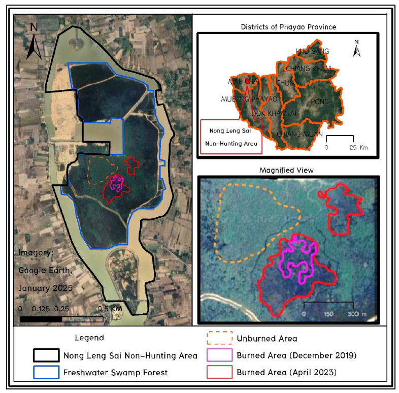
This study generated monthly time-series graphs of Sentinel-2 satellite-derived indices—Normalized Difference Vegetation Index (NDVI), Normalized Difference Moisture Index (NDMI), and Normalized Difference Drought Index (NDDI)—to evaluate post-fire recovery and drought dynamics in the freshwater swamp forest of Nong Leng Sai Wildlife Sanctuary, Phayao Province. Using data from January 2018 to December 2024, we assessed vegetation health, moisture content, and drought severity. The results revealed gradual ecosystem recovery following the first wildfire (December 11-12, 2019), with seasonal fluctuations observed across all indices. However, the second wildfire (April 18-27, 2023) abruptly disrupted this trend, underscoring the vulnerability of peat swamp forests to repeated disturbances. The study underscores the utility of multi-temporal Sentinel-2 data in monitoring ecosystem resilience and supporting restoration strategies.
References
Anzooman, M., McKenna, P. B., Ufer, N., Baumgartl, T., McIntyre, N., & Shaygan, M. (2024). Assessing the post-fire recovery of mined-under temperate highland peat swamps on sandstone. Land, 13(12), 2253. Form https://doi.org/10.3390/land13122253.
Avetisyan, D., Velizarova, E., & Filchev, L. (2022). Post-fire forest vegetation state monitoring through satellite remote sensing and in situ data. Remote Sensing, 14(24), 6266. Form https://doi.org/10.3390/rs14246266.
Ballhorn, U., Siegert, F., Mason, M., & Limin, S. (2009). Derivation of burn scar depths and estimation of carbon emissions with LIDAR in Indonesian peatlands. Proceedings of the National Academy of Sciences, 106(50), 21213–21218. Form https://doi.org/10.1073/pnas.0906457106.
Chazdon, R. L. (2008). Beyond deforestation: restoring forests and ecosystem services on degraded lands. Science, 320(5882), 1458–1460. Form https://doi.org/10.1126/science.1155365.
Clerici, N., Weissteiner, C. J., & Paracchini, M. L. (2017). Data fusion of different spatial resolution remote sensing images for land cover mapping: A review of the literature and a case study. International Journal of Remote Sensing, 38(10), 2345–2375. Form https://doi.org/10.1080/01431161.2016.1266111.
Datt, B. (1999). A new reflectance index for remote sensing of chlorophyll content in higher plants: Tests using eucalyptus leaves. Journal of Plant Physiology, 154(1), 30–36. Form https://doi.org/10.1016/S0176-1617(99)80314-9.
Davies, G. M., Gray, A., Rein, G., & Legg, C. J. (2013). Peat consumption and carbon loss due to smouldering wildfire in a temperate peatland. Forest Ecology and Management, 308, 169–177. Form https://doi.org/10.1016/j.foreco.2013.07.051.
Drusch, M., Del Bello, U., Carlier, S., Colin, O., Fernandez, V., Gascon, F., ... & Bargellini, P. (2012). Sentinel-2: ESA's optical high-resolution mission for GMES operational services. Remote Sensing of Environment, 120, 25–36. Form https://doi.org/10.1016/j.rse.2011.11.026.
Gao, B. C. (1996). NDWI—A normalized difference water index for remote sensing of vegetation liquid water from space. Remote Sensing of Environment, 58(3), 257–266. Form https://doi.org/10.1016/S0034-4257(96)00067-3.
Gitas, I. Z., Mitri, G. H., & Ventura, G. (2004). Object-based image classification for burned area mapping of Creus Cape, Spain, using NOAA-AVHRR imagery. Remote Sensing of Environment, 92(3), 409–413. Form https://doi.org/10.1016/j.rse.2004.06.006.
Gorelick, N., Hancher, M., Dixon, M., Ilyushchenko, S., Thau, D., & Moore, R. (2017). Google Earth Engine: Planetary-scale geospatial analysis for everyone. Remote Sensing of Environment, 202, 18–27. Form https://doi.org/10.1016/j.rse.2017.06.031.
Gu, Y., Brown, J. F., Verdin, J. P., & Wardlow, B. (2007). A five-year analysis of MODIS NDVI and NDWI for grassland drought assessment over the central Great Plains of the United States. Geophysical Research Letters, 34(6), L06407. Form https://doi.org/10.1029/2006GL029127.
Gu, Y., Hunt, E., Wardlow, B., Basara, J. B., Brown, J. F., & Verdin, J. P. (2008). Evaluation of MODIS NDVI and NDWI for vegetation drought monitoring using Oklahoma Mesonet soil moisture data. Geophysical Research Letters, 35(22), L22401. Form https://doi.org/10.1029/2008GL035772.
Hardisky, M. A., Klemas, V., & Smart, R. M. (1983). The influence of soil salinity, growth form, and leaf moisture on the spectral radiance of Spartina alterniflora canopies. Photogrammetric Engineering and Remote Sensing, 49(1), 77–83.
Hoscilo, A., Page, S. E., Tansey, K. J., & Rieley, J. O. (2011). Effect of repeated fires on land-cover change on peatland in southern Central Kalimantan, Indonesia, from 1973 to 2005. International Journal of Wildland Fire, 20(4), 578–588. Form https://doi.org/10.1071/WF10029.
Huete, A., Didan, K., Miura, T., Rodriguez, E. P., Gao, X., & Ferreira, L. G. (2002). Overview of the radiometric and biophysical performance of the MODIS vegetation indices. Remote Sensing of Environment, 83(1–2), 195–213. Form https://doi.org/10.1016/S0034-4257(02)00096-2.
Hyndman, R. J., & Athanasopoulos, G. (2021). Forecasting: Principles and practice (3rd ed.). OTexts. Form https://otexts.com/fpp3/.
Immitzer, M., Vuolo, F., & Atzberger, C. (2016). First experience with Sentinel-2 data for crop and tree species classifications in central Europe. Remote Sensing, 8(3), 166. Form https://doi.org/10.3390/rs8030166.
Jin, S., & Sader, S. A. (2005). MODIS time-series imagery for forest disturbance detection and quantification of patch size effects. Remote Sensing of Environment, 99(4), 462–470. Form https://doi.org/10.1016/j.rse.2005.09.017.
Key, C. H., & Benson, N. (2006). Landscape assessment: Ground measure of severity, the composite burn index; and remote sensing of severity, the normalized burn ratio. In FIREMON: Fire Effects Monitoring and Inventory System (pp. LA-1–LA-51). USDA Forest Service, RMRS-GTR-164-CD.
Lentile, L. B., Holden, Z. A., Smith, A. M. S., Falkowski, M. J., Hudak, A. T., Morgan, P., ... & Benson, N. C. (2006). Remote sensing techniques to assess active fire characteristics and post-fire effects. International Journal of Wildland Fire, 15(3), 319–345. Form https://doi.org/10.1071/WF05097.
MGRONLINE. (2023, April 26). Extreme Heat and Drought! Underground Smouldering Fire Spreads to ‘Khai’ Forest in the Middle of Phayao’s Large Swamp, Not Extinguished for Over 10 Days, Over 100 Rai of Conservation Forest Destroyed. Form https://mgronline.com/local/detail/9660000038638. (in Thai)
Nong Leng Sai Non-Hunting Area. (2023). Report on a Solution to the ‘Khai’ Forest Fire Problem in Nong Leng Sai Non-Hunting Area. Phayao. (in Thai)
Paengwangthong, W. (2021). Multitemporal Landsat imagery with optimum band ratio techniques for deciduous forest classification. International Journal of Geoinformatics, 17(2), 21-27. Form https://doi.org/10.52939/ijg.v17i2.1753.
Paengwangthong, W. (2022). Application of fuzzy multicriteria group decision-making to prioritize infectious waste incineration development in Phayao Province hospitals lacking supportive information. Science & Technology Asia, 27(4), 195-206. Form https://ph02.tci-thaijo.org/index.php/SciTechAsia/article/view/247907.
Paengwangthong, W., Arnan, S., & Kulsoontornrat, J. (2025). Divergent nighttime light dynamics in Bangkok and surrounding provinces during the COVID-19 pandemic: Insights from Google Earth Engine. Geographia Technica, 20(1), 97-111. Form https://doi.org/10.21163/GT_2025.201.08.
Page, S. E., Siegert, F., Rieley, J. O., Boehm, H. D., Jaya, A., & Limin, S. (2002). The amount of carbon released from peat and forest fires in Indonesia during 1997. Nature, 420, 61–65. Form https://doi.org/10.1038/nature01131.
Peat Swamp Story. (n.d.). The Last Peat Swamp Forest of Thailand. PeatSwamps.com. Form https://www.peatswamps.com/story. (in Thai).
Pettorelli, N., Vik, J. O., Mysterud, A., Gaillard, J. M., Tucker, C. J., & Stenseth, N. C. (2005). Using the satellite-derived NDVI to assess ecological responses to environmental change. Trends in Ecology & Evolution, 20(9), 503–510. Form https://doi.org/10.1016/j.tree.2005.05.011.
Phayao Provincial Office. (2019, April 20). Field Visit to Nong Leng Sai to Find Solutions for the Fire Problem in the Nong Leng Sai Area. Form https://www.phayao.go.th/allnew/2023/04/20/ลงพื้นที่หนองเล็งทราย-เ/. (in Thai)
Phayao Provincial Office. (2023a, April 24). The ‘Khai’ Forest Fire Situation in Nong Leng Sai Covers an Area of Approximately 120 Rai. Form https://www.phayao.go.th/allnew/2023/04/24/สถานการณ์ไฟไหม้ป่าไคร้/. (in Thai)
Phayao Provincial Office. (2023b, April 30). Firefighting Operations for the ‘Khai’ Forest Fire in Nong Leng Sai. Form https://www.phayao.go.th/allnew/2023/04/30/ปฏิบัติงานดับไฟไหม้ป่า/. (in Thai)
Phuphaniat, M., Jeefoo, P., & Paengwangthong, W. (2024, December). Estimating Monthly PM2.5 Levels using Integrated Satellite and Meteorological Data: A Case Study of Suphan Buri Province, Thailand [Paper presentation]. 2024 Geoinformatics for Spatial-Infrastructure Development in Earth and Allied Sciences (GIS-IDEAS), Chiang Rai, Thailand. Form https://doi.org/10.1109/GIS-IDEAS63212.2024.10991217.
Seub Nakhasathien Foundation. (n.d.). The Last Peat Swamp Forest of Thailand. Form https://www.seub.or.th/seub/บทความ/ป่าพรุผืนสุดท้ายของประ/. (in Thai)
Stankova, N. (2023). Post-Fire Recovery Monitoring Using Remote Sensing: A Review. Aerospace Research in Bulgaria, 35, 192–200. Form https://www.researchgate.net/publication/369940555.
Tucker, C. J. (1979). Red and photographic infrared linear combinations for monitoring vegetation. Remote Sensing of Environment, 8(2), 127–150. Form https://doi.org/10.1016/0034-4257(79)90013-0.
van Leeuwen, W. J. D. (2008). Monitoring the effects of forest restoration treatments on post-fire vegetation recovery with MODIS multitemporal data. Sensors, 8(3), 2017–2042. Form https://doi.org/10.3390/s8032017.
Wilson, E. H., & Sader, S. A. (2002). Detection of forest harvest type using multiple dates of Landsat TM imagery. Remote Sensing of Environment, 80(3), 385–396. Form https://doi.org/10.1016/S0034-4257(01)00318-2.