Classification of Sugarcane Plantation in One growing Season using Sentinel-2 Satellite Imagery and Random Forest Method on Google Earth Engine Platform
Keywords:
Remote sensing, Google Earth Engine, Random ForestAbstract
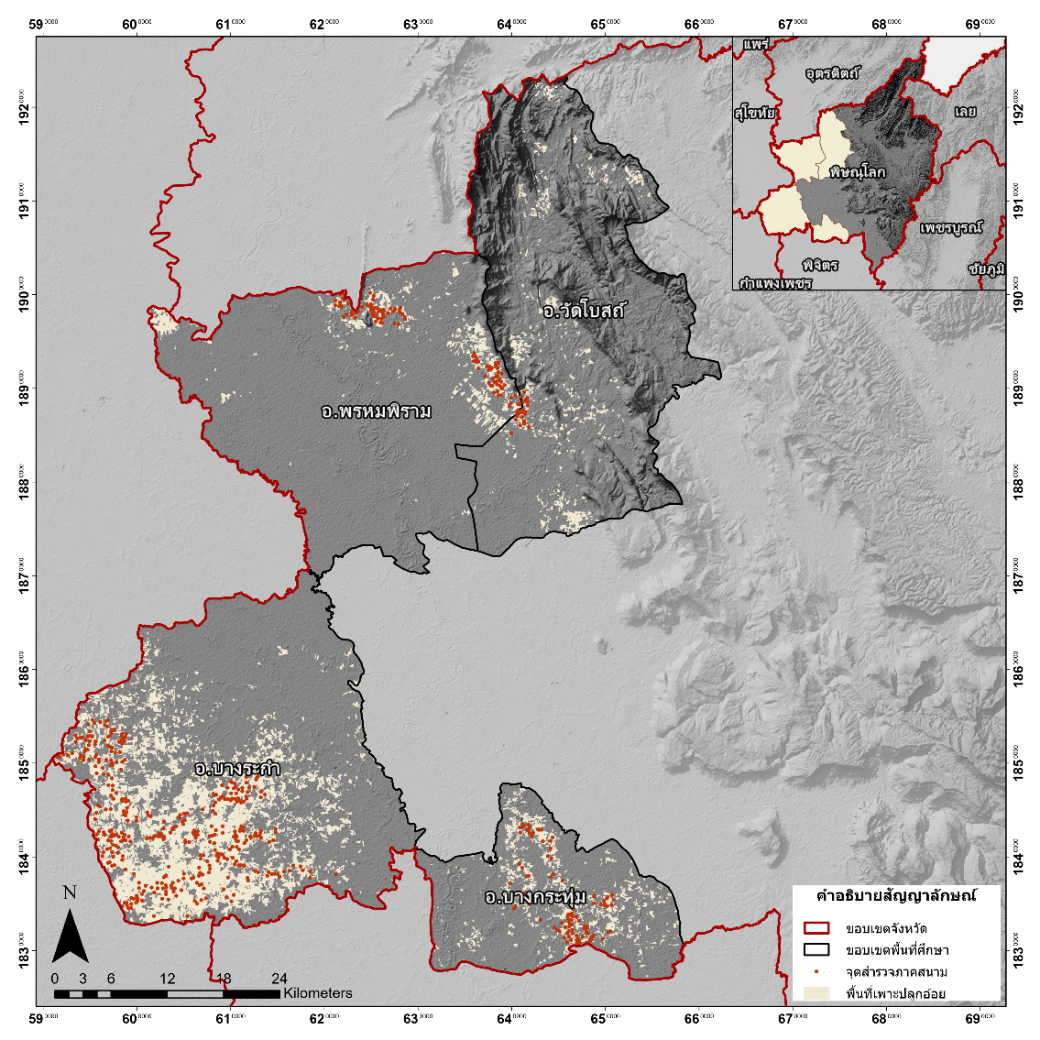
Sugarcane is a vital economic crop in Thailand, making a significant contribution to the agricultural sector. Spatial technology, particularly remote sensing, is extensively employed to monitor sugarcane plantations; however, challenges emerge due to constraints in computational resources. This study seeks to address these challenges by utilizing the Google Earth Engine (GEE) platform, which offers analytical capabilities akin to traditional geospatial software. The research specifically aims to evaluate the accuracy of sugarcane field mapping through the application of a random forest algorithm to Sentinel-2 satellite imagery using GEE. environment. The study area encompassed Rakam, Bang Krathum, Phrom Phiram, and Wat Bot districts in Phitsanulok Province. The analysis revealed significant changes in sugarcane plantation area throughout the 2023 growing season. Prior to the season (April 2023), the total sugarcane plantation area was estimated at 49,160.79 rai. During the peak of the growing season (November 2023), the area expanded considerably to 216,822.56 rai. Following the commencement of sugarcane harvesting by local factories in Phitsanulok Province, the cultivated area progressively decreased, reaching 87,779.43 rai by March 2024, before the start of the next planting season. Accuracy assessment yielded strong results: Kappa coefficients ranged from 0.78 to 0.95, producer's accuracy from 0.90 to 0.97, user's accuracy from 0.88 to 0.97, and overall accuracy from 0.91 to 0.98.
References
กองนโยบายและแผนพัฒนาการเกษตร. (2565). Agricultural Economic Outlook ภาวะเศรษฐกิจการเกษตรปี 2565 และแนวโน้มปี 2566 (ฉบับปี 2565). กรุงเทพฯ: สำนักงานเศรษฐกิจการเกษตร.
กองนโยบายและแผนพัฒนาการเกษตร. (2566). Agricultural Economic Outlook ภาวะเศรษฐกิจการเกษตรปี 2566 และแนวโน้มปี 2567 (ฉบับปี 2566). กรุงเทพฯ: สำนักงานเศรษฐกิจการเกษตร.
นครินทร์ ชัยแก้ว. (2560). Geographic Information Systems ระบบสารสนเทศภูมิศาสตร์ (พิมพ์ครั้งที่ 1). ISBN: 978-616-414-422-2.
สำนักงานพัฒนาเทคโนโลยีอวกาศและภูมิสารสนเทศ. (2558). ตำราเทคโนโลยีอวกาศและภูมิสารสนเทศศาสตร์. สำนักงานพัฒนาเทคโนโลยีอวกาศและภูมิสารสนเทศ (องค์การมหาชน) กระทรวงการอุดมศึกษา วิทยาศาสตร์ วิจัยและนวัตกรรม.
Elizabeth Champa-Bujaico, Ana M. D Díez-Pascual, Alba Lomas Redondo and Pilar Garcia-Diaz. (2024). Optimization of mechanical properties of multiscale hybrid polymer nanocomposites: A combination of experimental and machine learning techniques. ELSEVIER. Composites Part B, 269, 111099.
Felipe Cardoso de Oliveira Maia, Vinícius Bof Bufon and Tairone Paiva Leão. (2023). Vegetation indices as a Tool for Mapping Sugarcane Management Zones. Precision Agriculture, 24, 213–234.
Humberto Cruz-Sanabria1, Marıa Guadalupe S´anchez1, Juan Pablo Rivera-Caicedo2 and Himer Avila-George. (2021). Mapping Sugarcane using Vegetation Indices and Time Series of Sentinel-2 Images. 978-1-6654-0369-6/21.
Jie Wanga, Xiangming Xiaoa, Luo Liub, Xiaocui Wua, Yuanwei and Jean L. Steinerc. et al. (2020). Mapping sugarcane plantation dynamics in Guangxi, China, by time series Sentinel-1, Sentinel-2 and Landsat images. Remote Sensing of Environment, 247, 111951.
J. W. Rouse Jr., R. H. Haas, J. A. Schell and D. W. Deering. (1973). Monitoring Vegetation Systems in The Great Plains With ERTS.
Ming Wanga, Zhengjia Liub,c, Muhammad Hasan Ali Baigd, Yongsheng Wangb,c, Yurui Lib,c and Yuanyan Chena. (2019). Mapping sugarcane in complex landscapes by integrating multi-temporal Sentinel-2 images and machine learning algorithms. Land Use Policy, 88, 104190.
Russell G. Congalton. (1991). A Review of Assessing the Accuracy of Classifications of Remotely Sensed Data. Remote Sens. ENVIRON, 37, 35-46.
Shuai Xie 1,2, Liangyun Liu, Xiao Zhang, Jiangning Yang, Xidong Chen and andYuan Gao. (2019). Automatic Land-Cover Mapping using LandsatTime-Series Data based on Google Earth Engine. Remote Sens, 11, 3023.
Sudianto Sudianto a, Yeni Herdiyeni b and Lilik Budi Prasetyo. (2023). Classification of Sugarcane Area Using Landsat-8 and Random Forest based on Phenology Knowledge, 1974-1981.
Thanh Noi Phan, Verena Kuch and Lukas W. Lehnert. (2020). Land Cover Classification using Google Earth Engine and Random Forest Classifier—The Role of Image Composition. Remote Sens, 12, 2411.
Tri Muji Susantoro, Ketut Wikantika, Asep Saepuloh, Agus Handoyo and Harsolumakso. (2018). Selection of vegetation indices for mapping the sugarcane condition around the oil and gas field of North West Java Basin, Indonesia. Earth and Environmental Science, 149, 012001.