Application of Geoinformatics Technology for Route Management Connecting the Cultural Sites of Korat's Old Town
Keywords:
Cultural sire, Korat city's old town, Community Based Tourism, Geoinformatics, Network AnalysisAbstract
Tourism plays a role and is an essential strategy used in area development that helps strengthen
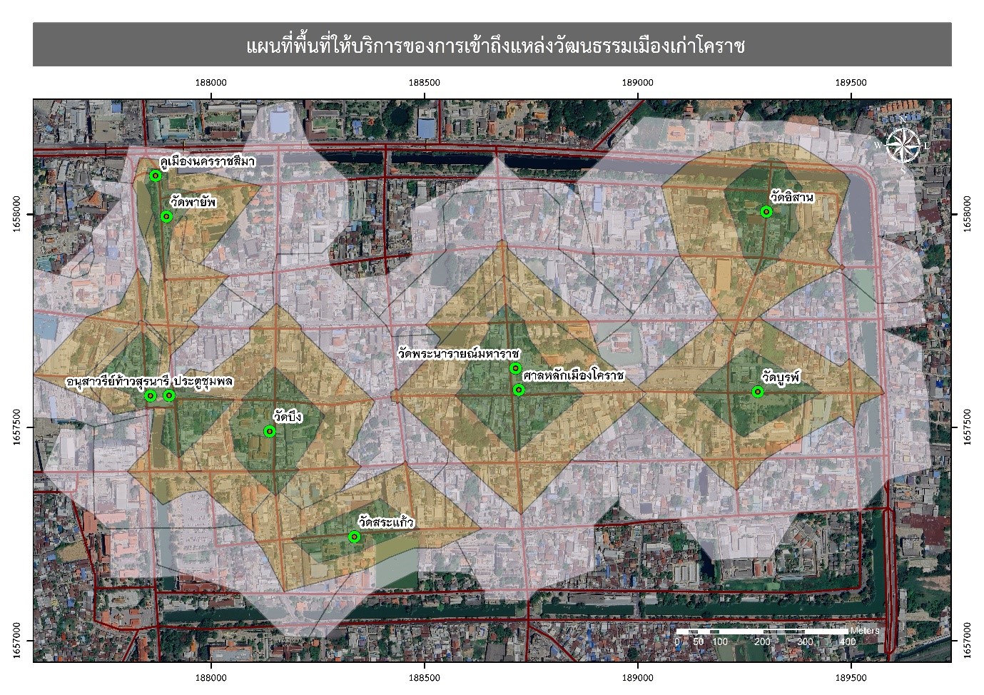
the community. This study aims to analyze routes connecting the cultural sites of Korat city's old town for supporting community tourism to the learning city by network analysis (best route analysis, closest facility analysis, and service area analysis) using road network and cultural sites of the Korat old city of Korat city's old town data. The study found that the best connectivity routes linking cultural sites in Korat’s old town include four routes: (1) a Pilgrimage route to explore the architecture of Korat city's old town, (2) a city tour route of Korat city's old town, (3) a route to explore arts and culture in Korat’s old town, and (4) a route to seek blessings from sacred sites in Korat city's old town. These routes range in total distance from 3.50 to 4.62 kilometers and take approximately 8.39 to 11.08 minutes to travel time. Meanwhile, the study also identified the shortest connectivity route between TK Square and cultural sites in Korat city's old town, which ranges from 66.97 to 1,857.12 meters and takes approximately 0.16 to 4.46 minutes of traveling time. In addition, the analysis of service areas providing access to cultural sites in Korat city's old town revealed that within distances of 150, 300, and 500 meters, the coverage areas accounted for 11.04%, 33.16%, and 68.65% of the total area, respectively. In summary, the results of this research contribute to the development of Korat City's cultural sites as learning spaces capable of presenting and disseminating information accurately and efficiently to tourists. Furthermore, they create opportunities for sustainable community tourism development and strengthen the local economy in the future.
References
จุฬามณี แก้วโพนทอง ทรงพล โชติกเวชกุล ปัญญา คล้ายเดช และ พระสุนทร ชำกรม. (2561). การบริหารจัดการชุมชนเพื่อความยั่งยืน. วารสารวิชาการธรรมทรรศน์, 18(1), 263-273.
ณรงค์ พลีรักษ์. (2556). ระบบสารสนเทศทางภูมิศาสตร์เพื่อการจัดการท่องเที่ยวชุมชนในจังหวัดชลบุรี. วารสารวิจัยและพัฒนา มจธ, 36(2), 235-248.
ดารียา บินดุสะ และ เอมอร อ่าวสกุล. (2561). การศึกษาศักยภาพแหล่งท่องเที่ยวชุมชนและธรรมชาติเพื่อพัฒนาเส้นทางการท่องเที่ยวอําเภอเมืองสตูล จังหวัดสตูล. การประชุมวิชาการด้านมนุษยศาสตร์และสังคมศาสตร์ระดับชาติ ครั้งที่ 1. คณะมนุษยศาสตร์และสังคมศาสตร์ มหาวิทยาลัยราชภัฏสงขลา.
ศิริเพ็ญ ดาบเพชร. (2557). การเลือกสถานที่ท่องเที่ยวของนักท่องเที่ยวครั้งแรกและนักท่องเที่ยวซ้ำ. วารสารบริหารธุรกิจ เศรษฐศาสตร์และการสื่อสาร, 9(2), 39-59.
สำนักงานสภาพัฒนาการเศรษฐกิจและสังคมแห่งชาติ. (2566). แผนพัฒนาเศรษฐกิจและสังคมแห่งชาติ ฉบับที่ 13 (พ.ศ. 2566 - 2570). สืบค้นจาก https://www.nesdc.go.th/article_attach/article_file_20230307173518.pdf.
Asian Center for Planning and Poverty Reduction. (2006). Guidelines on integrated planning for sustainable tourism development. Bangkok: Asian Center for Planning and Poverty Reduction.
Chang K-T., and Carl, M. (2019). Introduction to Geographic Information Systems (9th ed). McGraw-Hill.
ESRI. (2016). ArcGIS for Desktop 10.5. Environmental Systems Research Institute, Redlands.
Formica, S. (2000). Destination attractiveness as a function of supply and demand interaction. Retrieved from http://www.scholar.lib.vt.edu/theses/available/etd-11142000 -15560052.
Krutwaysho, O., & Chainark, S. (2018). Blue Tourism as a New Tourism form for Shaping Thailand into the Tourism Hub of the ASEAN Community. Journal of Management Science, Chiang Rai Rajabhat University, 13(2), 139-169.
Prameshwori, T., Wangshimenla, J., Surjit, L., and Ramananda, L. (2021). GIS Based Route Network Analysis for Tourist Places: A Case Study of Greater Imphal. International Journal of Scientific Research in Science, Engineering and Technology., 8(2), 233-238.


