Use of Sentinel-2 Image Data for Terrestrial Boundary Calculation of Thailand
Keywords:
The terrestrial boundaries of Thailand, Remote Sensing, Sentinel-2 Image, Visual interpretationAbstract
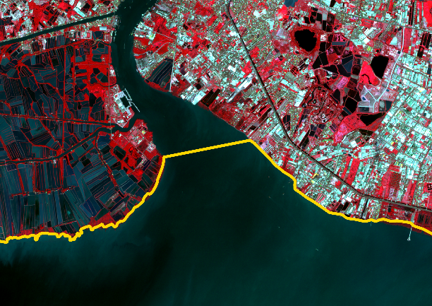
This study aims to compile the terrestrial boundary data of Thailand into a vector geographic information system using Universal Transverse Mercator (UTM) coordinates, Zone 47 North, with the primary datum as World Geodetic System 1984 (WGS 1984) from Sentinel-2 satellite imagery. The objective is to compare the boundary data derived from this study with those previously compiled by various government agencies.
The study found that the calculated area of Thailand's terrestrial boundary from this research is 321,204,866.73 acres (513,927.79 square kilometers). When comparing this boundary data with previously compiled data from other state agencies, it was observed that the Royal Thai Survey Department's boundary data shows the smallest difference, at 0.42%, equivalent to 1,370,404.46 acres (2,192.65 square kilometers). Comparatively, the Department of Lands's boundary data exhibits a slightly higher difference at 0.71%, equivalent to 2,304,335.74 acres (3,686.94 square kilometers). Finally, the largest difference was found with the boundary data from the Department of Provincial Administration, at 0.72%, equivalent to 2,323,832.92 acres (3,718.13 square kilometers).
References
กรมป่าไม้. (2565). รายงานฉบับสมบูรณ์ โครงการจัดทำข้อมูลสภาพพื้นที่ป่าไม้ ปี พ.ศ. 2565. สำนักจัดการที่ดินป่าไม้ กรมป่าไม้, กรุงเทพฯ.
กรมพัฒนาที่ดิน. (2533). การจำแนกที่ดินของประเทศไทย. กองแผนที่และการพิมพ์ กรมพัฒนาที่ดิน, กรุงเทพฯ.
กาญจน์เขจร ชูชีพ (2561). เอกสารคำสอน หลักการรบรระยะไกล. ภาควิชาการจัดการป่าไม้ คณะวนศาสตร์ มหาวิทยาลัยเกษตรศาสตร์, กรุงเทพฯ.
คณะกรรมการภูมิศาสตร์แห่งชาติ. (2527). เอกสารชุดภูมิศาสตร์ประเทศไทย เล่ม 1 ลักษณะทางกายภาพของประเทศไทย (พิมพ์ครั้งที่ 1). กรุงเทพฯ: สำนักพิมพ์วัฒนาพานิช.
วิโรจน์ เอี่ยมเจริญ. (2541). ภูมิศาสตร์กายภาพของประเทศไทย. โครงการตำราและเอกสารประกอบการเรียน คณะมนุษย์และสังคมศาสตร์ สถาบันราชภัฏพระนคร, กรุงเทพฯ.
วีระภาส คุณรัตนสิริ. (2563). การสำรวจทรัพยากรป่าไม้โดยใช้ภาพดาวเทียม. ภาควิชาการจัดการป่าไม้ คณะวนศาสตร์ มหาวิทยาลัยเกษตรศาสตร์, กรุงเทพฯ.
สำนักพัฒนาเทคโนโลยีอวกาศและภูมิสารสนเทศ. (2552). ตำราเทคโนโลยีอวกาศและภูมิสารสนเทศศาสตร์ (พิมพ์ครั้งที่ 1). กรุงเทพฯ: สำนักพิมพ์อมรินทร์พริ้นติ้งแอนด์พับลิชชิ่ง.
European Space Agency. (2015). SENTINEL-2 User Handbook, Retrieved from https://sentinel.esa.int/documents/247904/685211/Sentinel-2_User_Handbook.