Study on the Method of Sea Surface Chlorophyll-a Measurements Base-on Sentinel-3 Satellite Imagery in Coastal Areas of Trat Province
Keywords:
Chlorophyll-a, Sentinel-3, Algorithm, Coastal, Trat ProvinceAbstract
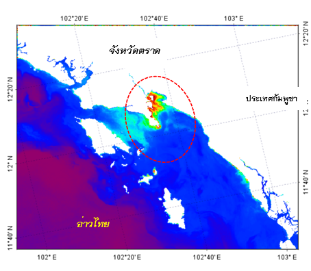
This research objective was studied on the method for measuring the amount of chlorophyll-a at the sea surface in coastal areas of Trat Province by using satellite image data. By using the reflectance properties measured by satellite sensors, which was analyzed together with data from in situ to create an algorithm that can be used to measure chlorophyll-a values. The useful in measuring of chlorophyll-a values which an appropriate method to obtain accurate and fast information and was obtained the spatial information in a wide area. This allows the results to be used to plan for further coastal management. Three cruise field data set were investigated from the south along coast of Trat province. Forty-five data sets were collected, including data from November 2020, January 2021, and March 2022. It was found that the average values were 0.65+0.38, 0.74+0.18, and 1.05+0.10 micrograms per liter, respectively. Then, input sea surface chlorophyll-a to three candidate algorithms were analyzed based on reflectance of Sentinel-3 satellite imageries which was calculated of radiance to reflectance. Correcting atmospheric distortion was used to develop the best algorithm derived from satellite data. The results showed that the OC3M algorithm gave the highest correlation value (R2=0.77) and was suitable for use
in estimating chlorophyll-a values in the coastal area of Trat Province. In addition, the results were compared
the relationship of the amount of chlorophyll-a which measured in the field with OC3M and NN algorithm from the Sentinel-3 satellite. It was found that the correlation coefficient (R=0.68) was not different. Therefore, it can be concluded that the NN algorithm from the Sentinel-3 satellite can be used to estimate sea surface chlorophyll-a values in the coastal area of Trat Province without having to analyze it through various algorithmic processes.
References
เบญจมาศ มีทรัพย์, อนุกูล บูรณประทีปรัตน์, ภัทราวุธ ไทยพิชิตบูรพา, สุธิดา กาญจน์อติเรกลาภ และ ศุภวัตร กาญจน์อติเรกลาภ. (2564). ฟลักซ์ของสารอาหารอนินทรีย์ละลายน้ำและตะกอนแขวนลอยที่บริเวณปากแม่น้ำตราด จังหวัดตราด ปี พ.ศ. 2561. วารสารวิทยาศาสตร์บูรพา, 26(1), 526-544.
ประสาร อินทเจริญ, อนุกูล บูรณประทีปรัตน์, อากิฮิโกะ โมริโมโตะ, เผชิญโชค จินตเศรณี และ วิโรจน์ ละอองมณี. (2561). อัลกอริทึมท้องถิ่นเพื่อการวิเคราะห์คลอโรฟิลล์-เอ ที่ผิวทะเลโดยใช้ข้อมูลภาพถ่ายดาวเทียม MODIS บริเวณอ่าวไทยตอนบน. วารสารวิทยาศาสตร์บูรพา, 23(2), 608-623.
ภัทราวุธ ไทยพิชิตบูรพา และ จารุมาศ เมฆสัมพันธ์. (2564). อิทธิพลของสารอาหารอนินทรีย์ละลายน้ำต่อการเปลี่ยนแปลงสภาวะยูโทรฟิเคช่ันในบริเวณอ่าวตราด จังหวัดตราด. วารสารวิทยาศาสตร์บูรพา, 26(2),770-782.
ภัทราวุธ ไทยพิชิตบูรพา, อนุกูล บูรณประทีปรัตน์, วิชญา กันบัว, ประสาร อินทเจริญ, เบญจวรรณ คชเสนี และ มิถิลา ปรานศิลป์. (2566). องค์ประกอบทางชนิดของแพลงก์ตอนพืชและคุณภาพน้ำบริเวณชายฝั่งทะเล จังหวัดตราด. วารสารวิทยาศาสตร์บูรพา, 28(2), 1363-1380.
ลัดดา วงศ์รัตน์. (2542). แพลงก์ตอนพืช. สำนักพิมพ์มหาวิทยาลัยเกษตรศาสตร์. กรุงเทพฯ.
สุจิตรา บุญจันทร์, มิถิลา ปรานศิลป์, อิสรา อาศิรนันต์ และ อนุกูล บูรณประทีปรัตน์. (2566). การศึกษากระแสน้ำไดเวอร์เจนซ์และคอนเวอร์เจนซ์บริเวณชายฝั่งจังหวัดตราด โดยใช้แบบจำลองอุทกพลศาสตร์. วารสารวิทยาศาสตร์บูรพา, 28(1), 175-194.
สุธิดา กาญจน์อติเรกลาภ, ศุภชัย ยืนยง, กุหลาบทิพย์ โพธิ์ทอง, ปวีณา โชติช่วง, อนุกูล บูรณประทีปรัตน์ และ ศุภวัตร กาญจน์อติเรกลาภ. (2560). ฟลักซ์ของสารอาหารอนินทรีย์ละลายน้ำและของแข็งแขวนลอยบริเวณปากแม่น้ำพังราด จังหวัดระยอง ในฤดูแล้งและฤดูน้ำมาก ในปี พ.ศ. 2558. วารสารวิทยาศาสตร์บูรพา, 22(3), 500-509.
อนุกูล บูรณประทีปรัตน์ และ อัญญดา มีสุข. (2556). การเปลี่ยนแปลงเชิงเวลาของปริมาณคลอโรฟิลล์-เอ บริเวณพื้นผิวทะเลอันดามันจากการประมวลผลภาพดาวเทียมอะควา โมดิส (Aqua MODIS). วารสารวิทยาศาสตร์บูรพา, 18(1), 194-201.
Leenawarat, D., Luang-on, J., Buranapratheprat, A. and Ishizaka, J. (2022). Influences of tropical monsoon and El Nino Southern Oscillations on surface chlorophyll-a variability in the Gulf of Thailand. Frontiers in Climate, 4, 936011 doi: 10.3389/fclim.2022.936011
O’Reilly, J. E., Maritorena, S., Siegel, D. A., O’Brien, M. C., Toole, D., Mitchell, B. G., ... & Culver, M. (2000). Ocean color chlorophyll-a algorithm for SeaWiFS, OC2, and OC4: Version 4. SeaWiFS postlaunch calibration and validation analyses, Part, 3, 9-23.
Matsumura, S., Siripong, A., & Lirdwitayaprasit, T. (2006). Underwater optical environment in the Upper Gulf of Thailand. Coastal Marine Science, 30(1), 36-43.
EUMETSAT. (2021). Sentinel-3 OLCI Marine User Handbook. EUM/OPS-SEN3/MAN/17/907205, v2G e-signed. Horning, N., Robinson, J. A., Sterling, E. J., Turner, W. & Spector, S. (2010). Remote sensing for ecology and conservation: a handbook of techniques. Oxford University Press.
Strickland, J. D. H. & Parson, T. R. (1972). A Practical Handbook of Seawater Analysis. Fishery Research Board of Canada, Ottawa.
Vanhellemont, Q. & Ruddick, K. (2021). Atmospheric correction of Sentinel-3/OLCI data for mapping of suspended particulate matter and chlorophyll-a concentration in Belgian turbid coastal waters. Remote sensing of environment, 256, 112284.