Performance Evaluation of Low-Cost Unmanned Aerial Vehicles for Surveying and Mapping of Buildings in Local Government Organization Application: A Case Study of Mae Ka Subdistrict Municipality
Keywords:
Low-Cost Unmanned Aerial Vehicles, Digital Photogrammetry, Orthophoto, Data Extraction, Local Government Organization ApplicationAbstract
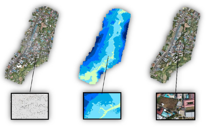
This research aims to evaluate the efficiency of low-cost unmanned aerial vehicles (UAVs) for surveying building and infrastructure data for the local government's organizational applications. The survey and mapping utilize low-cost UAVs for aerial photography in the densely built-up area around University of Phayao. The selected UAVs for this survey are DJI Phantom 4 Pro V2 and are set to fly at an altitude of 90 meters with 80% and 60% overlap for forward and side overlap, respectively. The image resolution is set at 2.45 centimeters per pixel. The acquired aerial images are then processed to generate point cloud data, orthophotos, and numerical elevation models. The image processing involves adjusting parameters for image alignment, creating 3D points at high and medium levels, and extracting building information to measure the area sizes at different scales, including 1:100, 1:250, and 1:500. After obtaining building and infrastructure data, an accuracy assessment is conducted by comparing it with the field survey data collected for the local municipality's tax map system. The results show that the orthophotos generated from low-cost UAV surveys closely match the surveyed data in terms of building and infrastructure sizes. The most accurate scales are found to be 1:250, 1:100, and 1:500, respectively. This study concludes that low-cost UAVs can effectively support traditional survey methods for building and infrastructure data collection.
References
คณะอนุกรรมการมาตรฐานการสำรวจด้วยอากาศยานไร้คนเพื่องานวิศวกรรม วิศวกรรมสถานแห่งประเทศไทย ในพระบรมราชูปถัมภ์. (2565). าตรฐานการสำรวจด้วยอากาศยานไร้คนเพื่องานวิศกรรม(พิมพ์ครั้งที่ 1). กรุงเทพฯ: สำนักพิมพ์วิศวกรรมสถานแห่งประเทศไทยในพระบรมราชูปถัมภ์.
จเด็จ ไพศาลสิทธิกานต์. (2562). การประยุกต์ใช้ระบบกล้องชุดถ่ายภาพเฉียงบนอากาศยานไร้คนขับเพื่อรังวัดรอยพิมพ์ฐานอาคาร กรณีศึกษาพื้นที่อาคารบ้านพักอากาศ. (วิศวกรรมศาสตรมหาบัณฑิต). สาขาวิชาวิศวกรรมสำรวจ ภาควิชาวิศวกรรมสำรวจ. กรุงเทพฯ: จุฬาลงกรณ์มหาวิทยาลัย.
ฝ่ายพัฒนารายได้ กองคลัง. (2563). คู่มือการปฏิบัติงานจัดเก็บรายได้. ฝ่ายพัฒนารายได้กองคลัง, สำนักงานเทศบาลตำบลแม่กา, อำเภอเมืองพะเยา จังหวัดพะเยา, 2.
พระราชบัญญัติภาษีที่ดินและสิ่งปลูกสร้าง พ.ศ. 2562. (2562, 9 มีนาคม). ราชกิจจานุเบกษา (เล่ม 136 ตอนที่ 30 ก, น. 25-32).
ไพศาล สันติธรรมนนท์. (2564). การรังวัดด้วยภาพดิจิทัล (พิมพ์ครั้งที่ 2) . กรุงเทพฯ: สำนักพิมพ์แห่งจุฬาลงกรณ์มหาวิทยาลัย.
มศวรรณ เสนาสวัสดิ์. (2566). การศึกษาความแม่นยำของการสำรวจแบบต่างๆ เพื่อการก่อสร้าง. การประชุมวิชาการวิศวกรรมโยธาแห่งชาติ ครั้งที่ 28 วันที่ 24-26 พฤษภาคม 2566. กรุงเทพฯ: ภาควิชาวิศวกรรมโยธา คณะวิศวกรรมศาสตร์ มหาวิทยาลัยศรีปทุม.
สำนักงานคณะกรรมการป้องกันและปราบปรามยาเสพติด. (2560). การจัดการองค์ความรู้เรื่องอากาศยานไร้คนขับเพื่อการสำรวจพืชเสพติด. เชียงใหม่: สถาบันสำรวจและติดตามการปลูกพืชเสพติดสำนักงานคณะกรรมการป้องกันและปราบปรามยาเสพติด.
Akar, A. (2017). Evaluation of Accuracy of Dems Obtained From Uav-Point Clouds For Different Topographical Areas. International Journal of Engineering and Geosciences, 2(3), 110-117.
Remondino, F., Barazzetti, L., Nex, F., Scaioni, M., & Sarazzi, D. (2011). UAV photogrammetry for mapping and 3d modeling–current status and future perspectives. The International Archives of the Photogrammetry, Remote Sensing and Spatial Information Sciences, January 38, 2011 (25-31). Zurich Switzerland.
Yastikli, N., Bagci, I., & Beser, C. (2013). The processing of image data collected by light UAV systems for GIS data capture and updating. The International Archives of the Photogrammetry, Remote Sensing and Spatial Information Sciences, 40, November 11–17, 2013 (267-270). Antalya Turkey.