Simulation and Prediction of land use using CLUMondo Model in Pattani Province
Keywords:
Land Use, Modelling, CLUMondo, PattaniAbstract
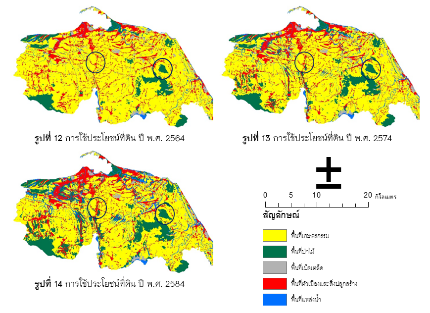
The objectives of land use forecast and land use change in Pattani Province are: (1) to forecast land use in 2018 and to assess the accuracy of the CLUMondo model, (2) to forecast land use in 2021, 2031, and 2041 and (3) to study the land use change from 2018 to 2041. The land use in 2007 and 2016 was addressed to forecast land use in 2018. The assessment of the accuracy of model was examined by using the land use in 2018 from the Department of Land Development. The overall accuracy and Kappa value were 0.98 and 0.97. According to the research results, the land use prediction in 2018 consisted of agriculture area, urban area, and forest covering the area of 1,451.26 square kilometers, 251.58 square kilometers, and 142.12 square kilometers, respectively. Land use forecast in 2021, the agriculture area has decreased from the year 2018, with an area of 38.66 square kilometers. Forest and miscellaneous have increased from the year 2018 by 21.50 square kilometers, 0.34 square kilometers, respectively. In 2031, agriculture area has decreased by 133.66 square kilometers, while forest and the miscellaneous have increased by 78.60 square kilometers and 0.10 square kilometers, respectively. In 2041, the agriculture area has decreased by 132.47 square kilometers, while the forest and miscellaneous have increased with an area of 76.67 square kilometers and 1.52 square kilometers, respectively. According to the research it realizes the land use change in the future and land use can be appropriately allocated.
References
คณะกรรมการบริหารงานจังหวัดแบบบูรณาการจังหวัดปัตตานี. (2558). แผนพัฒนาจังหวัดปัตตานี พ.ศ.2557-2560 ฉบับทบทวน (รอบปี พ.ศ.2560). ปัตตานี: สำนักงานจังหวัดปัตตานี.
ชุติพงศ์ ร่มสนธิ์. (2551). การคาดการณ์การเปลี่ยนแปลงการใช้ที่ดิน และสิ่งปกคลุมดิน โดยใช้แบบจำลอง CA-MARKOV บริเวณลุ่มน้ำแม่แจ่ม จังหวัดเชียงใหม่ (วิทยาศาสตรมหาบัณฑิต). สาขาการจัดการลุมน้ำและสิ่งแวดลอม, มหาวิทยาลัยเกษตรศาสตร์, กรุงเทพฯ.
ธณัชชัย วิยานนท์, ชูพันธุ์ ชมภูจันทร์, และ วิษุวัฒก์ แต้สมบัติ. (2563). การคาดการณ์การใช้ประโยชน์ที่ดินในลุ่มน้ำสาขาย่อยห้วยผาก จังหวัดเพชรบุรี ด้วยแบบจำลอง CA-Markov. การประชุมวิชาการสมาคมวิศวกรรมเกษตรแห่งประเทศไทย ระดับนานาชาติ ครั้งที่ 13 และระดับชาติ ครั้งที่ 21 (น. 250-257). ณ โรงแรมแคนทารี โคราช, นครราชสีมา.
นิติ เอี่ยมชื่น, วันณัชชา เทพวงศ์. (2563). การพยากรณ์การใช้ประโยชน์ที่ดินด้วยแบบจำลอง CLUmondo กรณีศึกษา อำเภอเมือง จังหวัดเชียงใหม่. วารสารวิชาการเพื่อการพัฒนานวัตกรรมเชิงพื้นที่, 1(2), 1-13.
ยงยุทธ ไตรสุรัตน์. (2558). The CLUMondo Land Use Change Model คู่มือการใช้โปรแกรมและแบบฝึกหัด. คณะวนศาสตร์, มหาวิทยาลัยเกษตรศาสตร์, กรุงเทพฯ, 61น.
วันณัชชา เทพวงศ์, ธิดาภัทร อนุชาญ และ นิติ เอี่ยมชื่น. (2565). การเปรียบเทียบแบบจำลอง CLUMondo และแบบจำลอง CA-Logistic ในการพยากรณ์การใช้ประโยชน์ที่ดินในเขตเมือง กรณีศึกษา อำเภอเมืองเชียงราย จังหวัดเชียงราย. วารสารวิทยาศาสตร์บูรพา, 27(3), 16187-1634.
วีระภาส คุณรัตนสิริ. (2563). การศึกษาเปรียบเทียบแบบจำลอง CA-Markov และแบบจำลอง CLUE-S เพื่อคาดการณ์การเปลี่ยนแปลงการใช้ประโยชน์ที่ดินพื้นที่ป่าสงวนแห่งชาติ จังหวัดน่าน. วารสารวิทยาศาสตร์ประยุกต์, 19(2), 78-100.
วุฒิพงษ์ นิลจันทร์. (2561). การเปรียบเทียบการคาดการณ์การใช้ประโยชน์ที่ดินและสิ่งปกคลุมดินโดยใช้ แบบจำลอง CA-MARKOV และ แบบจำลอง LAND CHANGE MODELER กรณีศึกษาจังหวัดพะเยา (ปริญญานิพนธ์ระดับปริญญาตรี). สาขาวิชาภูมิสารสนเทศศาสตร์, มหาวิทยาลัยพะเยา, พะเยา.
ส่วนบริหารและพัฒนาเทคโนโลยีการทะเบียนสำนักบริหารการทะเบียน. (2562). สถิติจำนวนประชากรและบ้าน. สืบค้นจาก https://stat.bora.dopa.go.th/stat/statnew/statINTERNET/fbclid=IwAR1XLPQgWlRdEEQ0yK3MO5KxrM8GKCpuqF9elrKC1OTtV7pV2sXZkSADtzo#/
Aynew Y. (2008). Rainfall – Runoff modelling for sustainable water resources management (Master of Science Thesis). School of Graduate Studies, Ethiopia Addis Ababa University, Ethiopia.
Cammerer, H., Thieken, A. H., & Verburg, P. H. (2013). Spatio-temporal dynamics in the flood exposure due to land use changes in the Alpine Lech Valley in Tyrol (Austria). Natural hazards, 68, 1243-1270.
Castella, J. C., & Verburg, P. H. (2007). Combination of process-oriented and pattern-oriented models of land-use change in a mountain area of Vietnam. Ecological modelling, 202(3-4), 410-420.
Fitzpatrick-Lins, K. (1981). Comparison of sampling procedures and data analysis for a land-use and land-cover map. Photogrammetric Engineering and Remote Sensing, 47(3), 343-351.
Fleiss, J. L., Levin, B., & Paik, M. C. (2013). Statistical methods for rates and proportions. john wiley & sons.
Gao, P., Gao, Y., Zhang, X., Ye, S., & Song, C. (2022). CLUMondo v2. 0: Improved model by adaptive determination of conversion orders for simulating land system changes with many-to-many demand-supply relationships. Geoscientific Model Development Discussions, 1-28.
Githui, F., Mutua, F., & Bauwens, W. (2009). Estimating the impacts of land-cover change on runoff using the soil and water assessment tool (SWAT): case study of Nzoia catchment, Kenya. Hydrological sciences journal, 54(5), 899-908.
Lin, Y. P., Verburg, P. H., Chang, C. R., Chen, H. Y., & Chen, M. H. (2009). Developing and comparing optimal and empirical land-use models for the development of an urbanized watershed forest in Taiwan. Landscape and Urban Planning, 92(3-4), 242-254.
Luo, G., Yin, C., Chen, X., Xu, W., & Lu, L. (2010). Combining system dynamic model and CLUE-S model to improve land use scenario analyses at regional scale: A case study of Sangong watershed in Xinjiang, China. Ecological Complexity, 7(2), 198-207.
Mehdi, B. B., Ludwig, R., & Lehner, B. (2012). Determining agricultural land use scenarios in a mesoscale Bavarian watershed for modelling future water quality. Advances in Geosciences, 31, 9-14.
Nassar, A. M., Harfuch, L., Bachion, L. C., & Moreira, M. R. (2011). Biofuels and land-use changes: searching for the top model. Interface Focus, 1(2), 224-232.
Oh, Y. G., Yoo, S. H., Lee, S. H., & Choi, J. Y. (2011). Prediction of paddy field change based on climate change scenarios using the CLUE model. Paddy and Water Environment, 9, 309-323.
Orekan, V. O. A. (2007). Implementation of the local land-use and land-cover change model CLUE-s for Central Benin by using socio-economic and remote sensing data (Doctoral dissertation). Universitäts-und Landesbibliothek Bonn, Germany.
Peng, Y., Xu, X., Yu, J., Liu, F., Qin, W., & Xia, Y. (2022). Spatial optimal allocation of land resources in Fengweihan, Kaishan, Laos. Natural Resources Conservation and Research, 5(1), 66-74.
Ruiqi, G. U. O., Bo, L. U., & Kailin, C. H. E. N. (2020). Dynamic simulation of multi-scenario land use change based on CLUMondo model: A case study of coastal cities in Guangxi. Remote Sensing for Natural Resources, 32(1), 176-183.
Schmalz, B., & Fohrer, N. (2009). Comparing model sensitivities of different landscapes using the ecohydrological SWAT model. Advances in Geosciences, 21, 91-98.
Trisurat, Y., Alkemade, R., & Verburg, P. H. (2010). Projecting land-use change and its consequences for biodiversity in Northern Thailand. Environmental Management, 45, 626-639.
Veldkamp, A., & Fresco, L. O. (1996). CLUE-CR: an integrated multi-scale model to simulate land use change scenarios in Costa Rica. Ecological modelling, 91(1-3), 231-248.
Verburg, P. H., Van de Steeg, J., & Schulp, N. (2005). Manual for the CLUE-Kenya application. Department of Environmental Sciences, Wageningen University, Wageningen, Netherlands, 54p.
Wang, H., Jin, Y., Hong, X., Tian, F., Wu, J., & Nie, X. (2022). Integrating IPAT and CLUMondo models to assess the impact of carbon peak on land use. Land, 11(4), 573.
Wu, J., Jin, X., Feng, Z., Chen, T., Wang, C., Feng, D., & Lv, J. (2021). Relationship of Ecosystem Services in the Beijing–Tianjin–Hebei Region Based on the Production Possibility Frontier. Land, 10(8), 881.
Yin, L., Dai, E., Xie, G., & Zhang, B. (2021). Effects of land-use intensity and land management policies on evolution of regional land system: A case study in the hengduan mountain region. Land, 10(5), 528.