Development of Near Real-Time analysis of Heatstroke Risk Information Service that affects to the elderly person based on Web Map Service
Keywords:
Web Processing Service, Open Data kit, Heat Index, Zoo-Project Platform, Foss4GAbstract
The number of elderly or citizen who is over 60 years old has been increasing every year which results in Thailand’s turning into aging society and the population structure change. In addition, the labor structure has changed in order for elderlies to work. The majority work in agriculture and fishing fields.
According to the global warming, the temperature keeps higher every year. Thailand as the tropical country has been effected by the higher temperature. The disease found in summer is heatstroke , the sickness ever occurred only in summer. The elderly who are in the risk group must be taken care of.
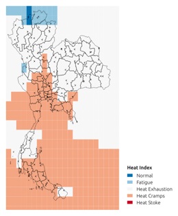
The objective of this study is to present the application of Open Data Kit (ODK) technology to collect the elderly data which can reduce the error and time period to record the data. It also helps the data surveying and collecting to be effective and accurate based on the clients’ demands. Moreover, the application supports the development of heat index resulting in heatstroke in elderly, higher than 32 degrees Celsius, which makes elderly to be in the risk group. The data analysis will employ the developed Open Source Software and support projects. FOSS4G is the GRASS GIS, ZOO and Web Processing Service that have been developed to be the web application, which can present the data in graph and map on the internet. The clients can monitor the real-time risk point of heatstroke through the internet without any payments.
References
Bandara, N., Fenoy, G,. Raghavan, V., & Yoshida, D. (2016). Simplifying integration of field data and GIS: A WPS approach. International Conference on GeoInformatics for Spatial-Infrastructure Development in Earth & Allied Sciences (GIS-IDEAS.
Bandara, N., Jayasingh, Raghavan, V & Yoshida, D. (2016). Development of Field Data Monitoring and Evaluation Platform using Customizable Mobile Application and Web-Mapping Tool. Thesis, Osaka City University.
Basinger, M., Jeffrey-Coker, F., & Mod, V. (2013). Open Data Kit: Implications for the Use of Smartphone Software Technology for Questionnaire Studies in International Development. Retrieved August 5, 2017, Retrieved from https://fsg.afre.msu.edu/Mozambique/.
Department of Health, 2017
Gadiwala, M. S., & Sadiq, N. (2008). The apparent temperature analysis of Pakistan using bio-meteorological indices. Pakistan Journal of Meteorology, 4(8). 15-26.
National Statistical Office, (2017)
.
National Weather Service. (2021).
Retrieved from https://www.wpc.ncep.noaa.gov/html/heatindex_equation.shtml.
Sittichai Choosumrong. (2022). The Online GIS. Geographic Association of Thailand, Phitsanulok. Strategy and Planning Division, Ministry of Public Health 2016.