Mapping Carbon Footprint of Rush-hour Traffic for Supporting Greenhouse Gas Emission Reduction Plan within University of Phayao
Keywords:
Traffic Count Data, Vehicle Emission, Spatial DatabaseAbstract
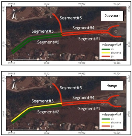
The objective of this study was to generate the map of on-road carbon footprint within University of Phayao based on rush-hour traffic count data. Processing of geographic information system was used for greenhouse gas (GHG) emission assessment. The road within study area was digitized and also separated into 5 segments relies on road intersection points. Field survey on (Friday) 25th and (Sunday) 27th February 2022 were represented as weekday and weekend traffic volume, respectively. After key-in data into Microsoft excel, fuel consumption, and GHG emission volume were sequentially calculated. Later on, the excel table data were joined into attribute table of the layer and presented as a map of carbon footprint. The result showed also that the procedure was possible and utilized as support data for GHG emission monitoring and minimizing.
References
กรมประชาสัมพันธ์. (2562). รายงานพิเศษ : “โลกร้อน” ภัยใกล้ตัว. สืบค้นจาก https://thainews.prd.go.th/th/news/detail/TCATG191114215504234.
กรมประชาสัมพันธ์. (2565). เร่งขับเคลื่อนงานแก้ไขปัญหาภาวะโลกร้อน เดินหน้าขยายผลในทุกจังหวัดและทุกองค์กรปกครองท้องถิ่นทั่วประเทศ. สืบค้นจาก https://thainews.prd.go.th/ th/news/detail/TCATG220320211731965.
กรุงเทพธุรกิจ. เมื่อ "โลกร้อน" ขึ้น 1.2 องศาฯ มนุษย์จะเจอ "ภัยพิบัติ" อะไรบ้าง?. สืบค้นจาก https://www.bangkokbiznews.com/social/967297.
กรุงเทพมหานคร. (2553). คู่มือคลายร้อนให้โลก (ที่)รัก. สำนักสิ่งแวดล้อม กรุงเทพมหานคร และ Japan International Cooperation Agency (JICA) หรือองค์การความร่วมมือระหว่างประเทศของญี่ปุ่น. สืบค้นจาก https://www.jica.go.jp/thailand/english/office/topics/c8h0vm0000bm5965-att/events100929_01.pdf.
กองการเจ้าหน้าที่. (2565). สรุปอัตรากำลังบุคลากรของมหาวิทยาลัยพะเยา ปี 2563. มหาวิทยาลัยพะเยา. สืบค้นจาก http://www.personnel.up.ac.th/ContentRead.aspx?c=อัตรากำลัง
เทศบาลตำบลบางกระบือ. (2555). Car Free Day ลดรถ ลดโลกร้อนกับกฏหมายพลังงานหมุนเวียน. สืบค้นจาก http://www.bangkrabuecity.go.th/site/attachments/article/155/Car%20Free%20Day%20ลดรถ%20ลดโลกร้อนกับกฏหมายพลังงานหมุนเวียน.pdf.
ระบบบริการการศึกษา. (2565). จำนวนนิสิตในปัจจุบัน. มหาวิทยาลัยพะเยา. สืบค้นจาก https://reg.up.ac.th/content/all/information.
วิภพ แพงวังทอง และอิสระพงษ์ กาจสาริการณ์. (2564). การประยุกต์ใช้ฐานข้อมูลสารสนเทศภูมิศาสตร์และการตัดสินใจกลุ่มแบบหลายเกณฑ์เพื่อประเมินความเสี่ยงไฟป่าในพื้นที่ป่าสงวนแห่งชาติของจังหวัดพะเยา. วารสารวิชาการเพื่อการพัฒนานวัตกรรมเชิงพื้นที่, 2(2), 13-24.
ศศิธร ฉัตรสุดารัตน์, (2560). การศึกษาและวิคราะห์การปลดปล่อยก๊าซเรือนกระจกในพื้นที่ปลูกอ้อยโดยเทคนิคการจำแนกเชิงวัตถุจากข้อมูลภาพถ่ายดาวเทียม Landsat: กรณีศึกษา อำเภอไทรงาม จังหวัดกำแพงเพชร. การประชุมวิชาการ (Proceedings) ทรัพยากรธรรมชาติ สารสนเทศภูมิศาสตร์ และสิ่งแวดล้อม ครั้งที่ 6 (NatGen 6th), วันที่ 24 – 25 กุมภาพันธ์ 2565 (น. 432-444). กรุงเทพฯ: ภาควิชาภูมิศาสตร์ คณะศึกษาศาสตร์ มหาวิทยาลัยรามคำแหง.
ศิริลักษณ์ พิมมะสาร, นครินทร์ ชัยแก้ว, และสิทธิชัย พิมลศรี. (2556). การประมาณค่าการปล่อยก๊าซมีเทนจากนาข้าวในจังหวัดพะเยา. วารสารนเรศวรพะเยา, 6(2), 116-127.
สิทธิชัย ชูสำโรง. (2559). รายวิชา 104333 การจัดการฐานข้อมูลและฐานข้อมูลภูมิสารสนเทศ [เอกสารประกอบการสอน]. พิษณุโลก: ภาควิชาทรัพยากรธรรมชาติและสิ่งแวดล้อม หาวิทยาลัยนเรศวร.
อบก. (2562). ค่าการปล่อยก๊าซเรือนกระจก (Emission Factor) รวบรวมมาจากข้อมูลทุติยภูมิสำหรับการประเมินคาร์บอนฟุตพรินท์ขององค์กร. สืบค้นจาก http://localcfo.tgo.or.th/uploads/ docs/20200311130041.pdf.
อบก. (2562). โครงการศึกษาและพัฒนาระบบสารสนเทศภูมิศาสตร์ (GIS) เพื่อแสดงการปล่อยและกักเก็บก๊าซเรือนกระจกในสาขาเกษตรป่าไม้และการใช้ประโยชน์ที่ดิน. สืบค้นจาก http://www.tgo.or.th/2020/index.php/ th/post/โครงการศึกษาและพัฒนาระบบสารสนเทศ.
อบก. (2565). TGO จับมือ FTI และ 29 องค์กรนำร่อง ร่วมส่งเสริมการจัดทำคาร์บอนฟุตพรินท์ขององค์กรในภาคอุตสาหกรรม. สืบค้นจาก http://www.tgo.or.th/2020/index.php/th/post/tgo-จับมือ-fti-และ-29-องค์กรนำร่อง-ร่วมส่งเสริมการจัดทำคาร์บอนฟุตพรินท์ขององค์กรใน.
อบก. (2565). TGO จับมือ VGREEN ร่วมขยายผลกิจกรรมชดเชยคาร์บอนเพื่อสนับสนุนตลาดคาร์บอน.
ภาคสมัครใจภายในประเทศ เพื่อมุ่งสู่เป้าหมาย Net Zero Emissions. สืบค้นจาก http://www.tgo.or.th/ 2020/index.php/th/post/tgo-จับมือ-vgreen-ร่วมขยายผลกิจกรรมชดเชยคาร์บอนเพื่อสนับสนุนตลาดคาร์บอน.
Bachman, W. H. (1998). A GIS-based modal model of automobile exhaust emissions. Washington, DC, USA: United States Environmental Protection Agency, Research and Development, National Risk Management Research Laboratory.
ENVIRONNET. (2559). การลดการปล่อยก๊าซเรือนกระจกภาคการขนส่งในบริบทโลก. ศูนย์สารสนเทศสิ่งแวดล้อม กรมส่งเสริมคุณภาพสิ่งแวดล้อมกระทรวงทรัพยากรธรรมชาติและสิ่งแวดล้อม. สืบค้นจาก http://www.environnet.in.th/archives/1533.
Gately, C., Hutyra, L. R., & Wing, I. S. (2019). DARTE annual on-road CO2 emissions on a 1-km grid, conterminous USA, v2, 1980-2017. ORNL DAAC.
Giovanni De Nunzio, Mohamed Laraki, and Lauren Thibault. (2020). Road Traffic Dynamic Pollutant Emissions Estimation: From Macroscopic Road Information to Microscopic Environmental Impact. Atmosphere 2021, 15(53), 1-23.
Greenpeace. (2564). ผลกระทบของภาวะโลกร้อน. สืบค้นจาก https://www.greenpeace.org/thailand/explore/protect/climate/impacts/.
iTIC. (2565). iTIC Traffic Live Web-based application. มูลนิธิศูนย์ข้อมูลจราจรอัจฉริยะไทย (The Intelligent Traffic Information Center Foundation). สืบค้นจาก https://iticfoundation.org/.
Kai Zhang, Stuart Batterman, and Francois Dion. (2011). Vehicle Emissions in Congestion: Comparison of Work Zone, Rush Hour and Free-flow Conditions, Atmospheric Environment, 45(11): 1929-1939.
Longdo. (2565). Longdo Traffic Web-based application. สืบค้นจาก https://traffic. longdo.com/th/.
Qingquan Li, Xiaomeng Chang, Xiaohui Cui, Luliang Tang, Zhiheng Li, and Liu Cheng. (2013). Road-Segment-Based Vehicle Emission Model for Real-Time Traffic Greenhouse Gas Estimation. IEEE TRANSACTIONS ON INTELLIGENT TRANSPORTATION SYSTEMS, 14(1), 469-479.
Suthichai Live. (2565). การเสวนาผ่านเฟสบุ๊คไลฟ์: คาร์บอนเครดิต สร้างโอกาสทางเครษฐกิจ ลดมลพิษอย่างยั่งยืน. สืบค้นจาก https://www.facebook.com/689751208/videos/509059280632349/.
TOMTOM. (2565). Bangkok traffic Web-based application. บริษัท ทอมทอม เนวิเกชั่น (ประเทศไทย) จำกัด. สืบค้นจาก https://www.tomtom.com/en_gb/traffic-index/bangkok-traffic/.
Zahra Gharineiat and Malik Khalfan. (2011). Using the Geographic Information System (GIS) in the Sustainable Transportation. World Academy of Science, Engineering and Technology International Journal of Geomatics and Civil Engineering, 5(11), 1425-1431.
Zihan Kan, Luliang Tang, Mei-Po Kwan, and Xia Zhang. (2018). Estimating Vehicle Fuel Consumption and Emissions Using GPS Big Data, International Journal of Environmental Research and Public Health, 15(4), 1-23.


