Application of Geoinformatics for Water Quality Monitoring in Kwan Phayao, Phayao Province
Keywords:
Geoinformatics, Kwan Phayao, Satellite image, Water quality indexAbstract
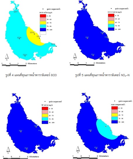
The main objective of the project on the application of Geoinformatics in water quality monitoring a case study of Kwan Phayao province is to apply Geoinformatics technology to monitor water quality and create a water quality index of Kwan Phayao to determine water quality zones. The method of operation consists of 7 steps: 1) geometry correction 2) satellite image classification to extract only the water source 3) creating water quality data layer from survey to geographic coordinates 4) adjusting data according to water quality standards 5) scoring according to the water quality standard for comparison from the water quality index 6) multiplying the score obtained by the weighted value at the specified level and 7) creating a water quality map by defining the water quality standard level by dividing the total standard score. The geospatial data was used to determine the water quality in Kwan Phayao by considering together with the data of 3 variables; 1) Biological Oxygen Demand (BOD); 2) Nitrate nitrogen (NO3-N) and 3) Total phosphate (TP) and use the water quality standard criteria to adjust the standard score range from the water quality index. Finally, the score is multiplied by the weight of the specified level to determine the water quality. The results showed that the values remained at a very good standard for both NO3-N and TP values while the BOD values were mostly good. The area near the city has a fair value. Overview of the three parameters was found to be in very good mainly but near the city was found in good level due to the influence of BOD.
References
Ritchie,J, C., Cooper,C, M., and Schiebe, F, R., (1990). The Relationship of MSS and TM Digital Data with Suspended Sediments, Chlorophyll, and Temperature in Moon Lake, Mississippi. Remote Sensing Environment 33:137-148.
Pattiaratchi, C, B., Lavery P., Wyllie, A., and Hick, P., (1994). Estimates of water-quality in coastal waters using multi-date Landsat Thematic Mapper data. International Journal of Remote Sensing 15(8):1571–84.
Ekercin, S., (2007). Water Quality Retrievals from High Resolution Ikonos Multispectral Imagery: A Case Study in Istanbul, Turkey. Water Air & Soil Pollution 183 (1-4): 239-251.
Wang and DeLiberty. (2005). Landsat Atmospheric Correction: The Good, the Bad, and the Ugly. ESRI User Conference Proceedings 2005 (International User Conference 25th). July 25–29, 2005. San Diego, California USA.
สำนักงานสิ่งแวดล้อมภาคที่ 2 ลำปาง. (2553). ข้อมูลคุณภาพน้ำประจำปี 2538-2552 [แฟ้มข้อมูล]. ลำปาง: สำนักงานสิ่งแวดล้อมภาคที่ 2 ลำปาง.
กรมส่งเสริมคุณภาพสิ่งแวดล้อม. (2537) คู่มือตรวจสอบคุณภาพสิ่งแวดล้อม.[ออนไลน์] ได้จาก
http://infofile.pcd.go.th/water/inspect_water.pdf?CFID=4038890&CFTOKEN=89571395
Song, T., and Kim, K., (2009). Development of a water quality loading index based on water quality modeling. Journal of Environmental Management. 90 (3): 1534–1543.
พงศ์เชฏฐ์ พิชิตกุล. (2548). คุณภาพน้ำในกว๊านพะเยา. การประชุมทางวิชาการของมหาวิทยาลัยเกษตรศาสตร์ ครั้งที่ 43: สาขาวิทยาศาสตร์ มหาวิทยาลัยเกษตรศาสตร์