Application of Geographic Information System to Evaluate Water Required for Agriculture: A Case Study of Watthana Nakhon Sub-District, Watthana Nakhon District, Sa Kaeo Province
Keywords:
Geographic Information / Water Required for Agriculture / Watthana Nakhon Sub-District, Watthana Nakhon District, Sa Kaeo ProvinceAbstract
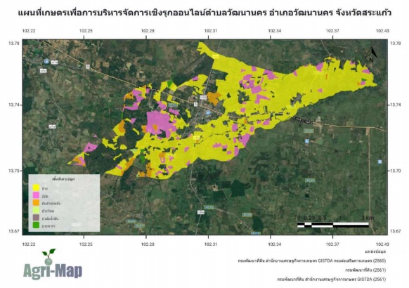
This study aimed to establish geographic information of agricultural areas in Watthana Nakhon Sub-District, Watthana Nakhon District, Sa Kaeo Province and to evaluate amount of water required for agriculture in 2021. The results of surveying performed in February, 2021 showed that the agricultural area in Watthana Nakhon Sub-District was approximately 40.101 million square meters or 25,063.28 rai. The most covered area was rice cultivation area of 31.226 million square meters (77.87 %), followed by sugarcane (18.00%), eucalyptus (3.01%), palm oil (0.54%), longan (0.29%), cassava (0.21%) and maize (0.08%), respectively. Comparing with the online agricultural map data (Agri-Map), it was found that the survey data had less than approximately 4,576.72 rai of agricultural land since the survey was performed out of growing season of rice and cassava. Thus, we did not find both two crops growing in the area. The amount of water required for agriculture estimated from the crops with most arable land (95.95%); rice, sugar cane and maize, was approximately 26.386 million cubic meters. The annual demand for rice was 18.411 million cubic meters or 69.78 %, followed by sugarcane and maize with water demand of 7.957 and 0.017 million cubic meters, respectively.