Landslide Risk Assessment using Geographic Information System: A case study of Phanom District, Surat Thani Province, Thailand
Keywords:
Landslide, Disaster Risk Area, Geographic Information SystemAbstract
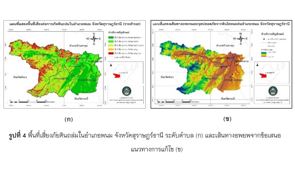
This research is the application of geographic information system to analyze landslide risk areas in Phanom district, Surat Thani province. The research objectives are 1) to study the physical factors affecting the landslide disaster in Phanom district, 2) to assess the level of landslide risk areas in Phanom district and 3) to propose solutions to prevent landslide disaster problems in Phanom district. The data used in the analysis consists of primary data and secondary data from relevant agencies combined with the factors assessment form by experts. In this research, the technique of spatial potential analysis uses PSA technique before analyzing the overlay of all factor by GIS. The study of risk factors for landslides in Phanom District found that the most influential factor affecting landslide is the average rainfall for the past 10 years. When overlaying all factors to classify the area at risk of landslides in Phanom district Surat Thani province, it shows that the level of landslide risk areas are the lowest, low, medium, high and the highest, respectively.