A Study on Geoinformation Standards and Its Application to Local Government Administration: A Case Study of Mae Ka Subdistrict Municipality
Keywords:
Geoinformation standard, Local government administration, web mapping serviceAbstract
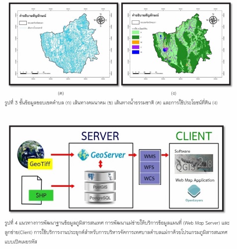
The purpose of this study is to explore and apply an appropriate geoinformation standards for developing a geospatial database to support an administration of Mae Ka local municipality. To understand their missions and the needs of Geoinformation application, questionnaire surveys and personal interviews were accomplished to correct a key information. The results reveal the necessary Geoinformation standards comprising of Metadata, Simple feature access (SFA), Imagery and gridded data, Web Map Service (WMS), and the Web Feature Service (WFS). Furthermore, there are the four fundamental geographic datasets for government administration consist of transportation, land use/land cover, administrative boundary and the natural stream. These results indicate that the Geoinformation standard implementation is the key for effective administration of Mae Ka local municipality. The local government can take some advantage of implemented Geoinformation standards to avoid overproduction of the geographic dataset and its can reduce the cost of the data acquisition and it also provide sharing, retrieving and integrating their own datasets/services to other organization (interoperability).