Flood Susceptibility Mapping Using Frequency Ratio and Statistical Index Methods, A Case Study of Nakhon Sawan Province
Keywords:
Flood, Frequency Ratio, Statistical IndexAbstract
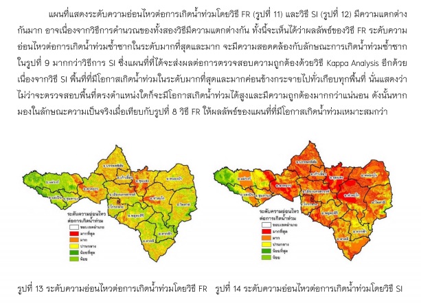
The objectives of this research were 1) to analyze and map the flood susceptibility areas in Nakhon Sawan Province by applying geographic information system together with frequency ratio (FR) and statistical index methods (SI) and 2) to compare the accuracy of flood susceptibility maps. In this study, 7 factors used including slope, land use and land cover, elevation, stream network density, road network density and annual rainfall. All factors were analyzed together with flood areas that had occurred between 2007-2016 by dividing the flood patterns into 2 types which were repeatedly flooded and areas that had previously been flooded and never flooded in order to formulate flood susceptibility map in Nakhon Sawan province. The results found that the areas that were the highest susceptibility area, high, moderate, low and the lowest in the case of repeated flooding, frequency ratio method covered area 669.12 sq.km, 190.74 sq.km., 283.48 sq.km., 5,719.75 sq.km. and 2,651.34 sq.km., respectively. The SI method covered area 1,566.91 sq. Km. 3,651.75 sq. Km. 3,145.81 km. 1,044.17 km. And 105.78 sq. Km., respectively. In the case of flooded areas and never flooded, the frequency ratio method covered 242.58 sq.km., 2,400.17 sq.km., 4,385.40 sq.km., 2,189.33 sq.km. and 296.94 sq.km., respectively. The SI method were 2,034.85 sq.km., 5,107.32 sq.km., 1,884.46 sq.km., 371.80 sq.km. and 115.99 sq.km., respectively. Flood susceptibility map in Nakhon Sawan Province in case of repetitive flood areas using FR and SI method had the accuracy of 80.13% and 89.06%, respectively while flooded and never flooded areas, FR and SI method had the accuracy of 78.34% and 88.12%, respectively. The SI method was more effective in finding flood susceptibility areas than the FR method.