
การพัฒนาระบบแจ้งเหตุฉุกเฉินด้วยเซนเซอร์ระบุตำแหน่งเพื่อวิเคราะห์เส้นทางในการเข้าถึงสำหรับการให้บริการการแพทย์ฉุกเฉินด้วยอินเทอร์เน็ตของสรรพสิ่งและ Open Route Service
Article Sidebar
Main Article Content
บทคัดย่อ
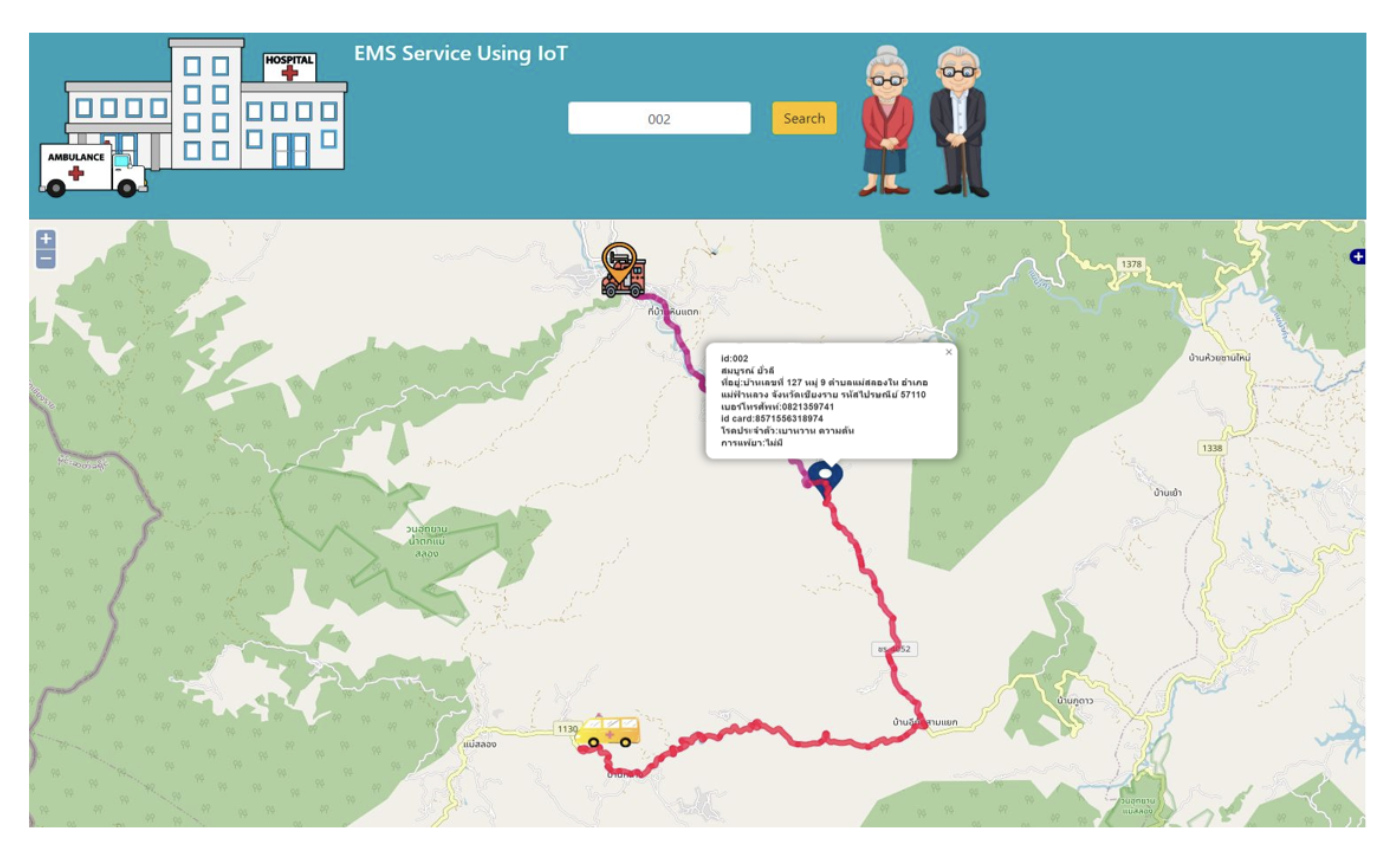
ในสังคมปัจจุบัน การเกิดอุบัติเหตุหรือการเจ็บป่วยฉุกเฉินมีแนวโน้มเพิ่มมากขึ้นเรื่อยๆ จนกลายเป็นปัญหาอย่างหนึ่งของสังคม โดยสาเหตุเกิดจากการไม่ได้รับการรักษาพยาบาลอย่างถูกต้องและทันท่วงที ซึ่งปัญหาเกิดจากผู้แจ้งเหตุบอกตำแหน่งของผู้แจ้งเหตุฉุกเฉินไม่ชัดเจนหรือการเดินทางของรถโรงพยาบาลหรือรถกู้ชีพประสบปัญหากับทางจราจรที่คับคั่ง ส่งผลให้ผู้ป่วยฉุกเฉินได้รับข้อบกพร่องทางร่างกาย จนกลายเป็นเหตุให้เสียโอกาสในการรอดชีวิตได้ การศึกษาครั้งนี้จึงได้พัฒนาระบบแจ้งเหตุฉุกเฉินด้วยเซนเซอร์ระบุตำแหน่งและพัฒนาระบบค้นหาเส้นทางที่เหมาะสมที่สุดในการเข้าถึงผู้ป่วยฉุกเฉินบน Web Map Application โดยมีวัตถุประสงค์คือ 1) ออกแบบระบบแจ้งเหตุฉุกเฉินเพื่อใช้ในการติดตามตำแหน่งของผู้แจ้งเหตุได้แบบเรียลไทม์โดยใช้การ Geo-IoT และ 2) เพื่อพัฒนาระบบค้นหาเส้นทางการให้บริการการแพทย์ฉุกเฉินบน Web Map Application และ pgRouting การพัฒนาระบบค้นหาเส้นทางนี้ได้เลือกใช้ซอฟแวร์รหัสเปิด (Free and Open-Source Software for Geospatial : FOSS4G) มาใช้ในการพัฒนาระบบทั้งหมด ส่วนเงื่อนไขในการสืบค้นและวิเคราะห์โครงสร้างถนนผู้วิจัยได้ใช้ pgRouting Library เข้ามาช่วยในการวิเคราะห์หาเส้นทางที่สั้นที่สุด โดยผลการศึกษาครั้งนี้พบว่าระบบที่พัฒนาขึ้นสามารถนำไปใช้ในการสนับสนุนงานด้านการให้บริการการแพทย์ฉุกเฉินได้ ทำให้สามารถค้นหาตำแหน่งของผู้แจ้งเหตุฉุกเฉินได้รวดเร็วกว่าเดิม และช่วยเพิ่มประสิทธิภาพในการแจ้งเหตุฉุกเฉินได้แบบเรียลไทม์ ส่งผลให้ผู้แจ้งเหตุฉุกเฉินจะได้รับการรักษาพยาบาลที่ทันเวลาและรวดเร็ว
Article Details

This work is licensed under a Creative Commons Attribution-NonCommercial-NoDerivatives 4.0 International License.
ผู้แต่งจะต้องกรอกข้อมูลเพื่อโอนลิขสิทธิ์ (copyright) ให้กับวารสารวิทยาการสารสนเทศและเทคโนโลยีประยุกต์ ก่อนเผยแพร่บทความ โดยดูรายละเอียดเพิ่มเติมได้ที่ https://ph01.tci-thaijo.org/index.php/jait/copyrightlicense


References
Atmoko, R. A., Riantini, R., & Hasin, M. K. (2017). IoT real time data acquisition using MQTT protocol. Proceeding of International Conference on Physical Instrumentation and Advanced Materials, 27 October 2016, Surabaya, Indonesia, 012003. https://doi.org/10.1088/1742-6596/853/1/012003
Choosumrong, S., Raghavan, V., & Realini, E. (2010). Implementation of dynamic cost based routing for navigation under real road conditions using FOSS4G and OpenStreetMap. Proceedings of GeoInformatics for Spatial-Infrastructure Development in Earth & Allied Sciences (GIS-IDEAS), Hanoi, Vietnam, 9-11 December 2010, 53-58.
Choosumrong, S., Raghavan, V., Delucchi, L., Yoshida, D., & Vinayaraj, P. (2014). Implementation of dynamic routing as a web service for emergency routing decision planning. International Journal of Geoinformatics, 10(2), 13-20. https://doi.org/10.52939/ijg.v10i2.373
Choosumrong, S., Humhong, C., Raghavan, V., & Fenoy, G. (2019). Development of optimal routing service for emergency scenarios using pgRouting and FOSS4G. Spatial Information Research, 27, 465-474. https://doi.org/10.1007/s41324-019-00248-2
Choosamrong, S. (2022). The Online GIS, Phitsanulok: Rattanasuwan Publishing House 3. [In Thai]
Humhong, C., Choosumron, S., & Homhuan, S. (2016). Development of spatial decision support system for considering staff dormitory of Naresuan University using FOSS4G. Naresuan University Journal: Science and Technology (NUJST), 24(1), 115-127. https://www.journal.nu.ac.th/NUJST/article/view/1274 [In Thai]
Klawwikarn, P., & Jirakajohnkool, S. (2014). Application of geographic information system for service area analysis of emergency medical service Centers in Loei Province. Thai Journal of Science and Technology, 3(3), 137-147. https://li01.tci-thaijo.org/index.php/tjst/article/view/21037 [In Thai]
Chuenban, K., et al. (2013). Web application for displaying flood-affected areas and giving directions to avoid risky areas. Computer Engineering Department. Faculty of Engineering Kasetsart University Kamphaeng Saen Campus. [In Thai]
Kaewwilai, L. (2022). Comprehensive geriatric assessment in community: Roles of nurse practitioner. Journal of Public Health Nursing, 36(1), 135–152. https://he01.tci-thaijo.org/index.php/phn/article/view/254538 [In Thai]
Mali, V., Rao, M., & Mantha, S. S. (2012). Enhanced routing in disaster management based on GIS. Proceeding of International Conference on Intuitive Systems & Solutions, Mumbai, India, January 5-6, 2012, 14-18. https://www.ijcaonline.org/proceedings/iciss/number1/7952-1004
Majumdar, N., Bhargava, P., & Shirin, R. K. (2014). Emergency panic button using microcontrollers. International Journal of Computer Applications, 99(9), 1-3. https://www.ijcaonline.org/archives/volume99/number9/17398-7955
Raksakhom, P. (2016) Development of optimal routing system for emergency medical service: Case study of Muang Phitsanulok (Bachelor Thesis). Phitsanulok, Naresuan University. Retrieved from https://www.agi.nu.ac.th/nred/Document/is-PDF/2559/geo_2559_024_FullPaper.pdf
Rerkyuksuk, S., et al. (2013). Open code software and free closed source geospatial resources for geospatial applications. School of Science Suranaree University of Technology
Rattanapoka, C., Chanthakit, S., Chimchai, A., & Sookkeaw, A. (2019). An MQTT-based IoT cloud platform with flow design by Node-RED. Proceeding of Research, Invention, and Innovation Congress (RI2C), Bangkok, Thailand, December 11-13, 2019, 1-6. https://doi.org/10.1109/RI2C48728.2019.8999942
Wangsri, K. (2013). The EMS system in Thailand. Srinagarind Medical Journal, 28(4 Suppl), 69-73. https://li01.tci-thaijo.org/index.php/SRIMEDJ/article/view/14763 [In Thai]