
Development of an Emergency Notification System with GPS Sensors to Analyze Access Routes for Emergency Medical Services using IoT and Open Route Service
Article Sidebar
Main Article Content
Abstract
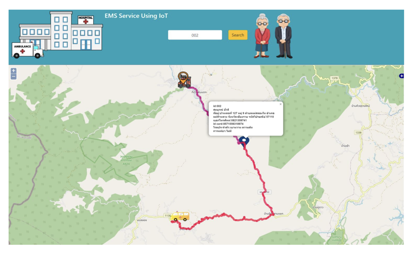
In present-day society, the occurrence of accidents and emergency illnesses has been consistently increasing, to the point where it has become a significant social issue. The cause is due to the lack of proper and timely medical treatment. The problem arises from the informer stating the location of the emergency caller is not clear or the journey of the ambulance car or emergency rescue vehicle was having problems with congested traffic. As a result, emergency patients suffer physical defects, leading to a reduced chance of survival. This study therefore developed an emergency notification system with positioning sensors and developed a system to find the most suitable route to reach emergency patients via Web Map Application. The goals of this study are 1) creating a Geo-IoT based emergency notification system to track the informant's whereabouts in real time, and 2) To develop a route search system for emergency medical services on Web Map Application and pgRouting. The development of this route search system uses the Free and Open-Source Software for Geospatial (FOSS4G) to develop the entire system. As for searching and analyzing road structures, the researcher used the pgRouting Library to help analyze the shortest path. The result of this study revealed that the developed system can be used to support the work of providing emergency medical services. It helps locate the emergency caller faster than before and improves efficiency in real-time emergency notification. As a result, the whistleblower will receive timely and rapid medical treatment.
Article Details

This work is licensed under a Creative Commons Attribution-NonCommercial-NoDerivatives 4.0 International License.
All authors need to complete copyright transfer to Journal of Applied Informatics and Technology prior to publication. For more details click this link: https://ph01.tci-thaijo.org/index.php/jait/copyrightlicense


References
Atmoko, R. A., Riantini, R., & Hasin, M. K. (2017). IoT real time data acquisition using MQTT protocol. Proceeding of International Conference on Physical Instrumentation and Advanced Materials, 27 October 2016, Surabaya, Indonesia, 012003. https://doi.org/10.1088/1742-6596/853/1/012003
Choosumrong, S., Raghavan, V., & Realini, E. (2010). Implementation of dynamic cost based routing for navigation under real road conditions using FOSS4G and OpenStreetMap. Proceedings of GeoInformatics for Spatial-Infrastructure Development in Earth & Allied Sciences (GIS-IDEAS), Hanoi, Vietnam, 9-11 December 2010, 53-58.
Choosumrong, S., Raghavan, V., Delucchi, L., Yoshida, D., & Vinayaraj, P. (2014). Implementation of dynamic routing as a web service for emergency routing decision planning. International Journal of Geoinformatics, 10(2), 13-20. https://doi.org/10.52939/ijg.v10i2.373
Choosumrong, S., Humhong, C., Raghavan, V., & Fenoy, G. (2019). Development of optimal routing service for emergency scenarios using pgRouting and FOSS4G. Spatial Information Research, 27, 465-474. https://doi.org/10.1007/s41324-019-00248-2
Choosamrong, S. (2022). The Online GIS, Phitsanulok: Rattanasuwan Publishing House 3. [In Thai]
Humhong, C., Choosumron, S., & Homhuan, S. (2016). Development of spatial decision support system for considering staff dormitory of Naresuan University using FOSS4G. Naresuan University Journal: Science and Technology (NUJST), 24(1), 115-127. https://www.journal.nu.ac.th/NUJST/article/view/1274 [In Thai]
Klawwikarn, P., & Jirakajohnkool, S. (2014). Application of geographic information system for service area analysis of emergency medical service Centers in Loei Province. Thai Journal of Science and Technology, 3(3), 137-147. https://li01.tci-thaijo.org/index.php/tjst/article/view/21037 [In Thai]
Chuenban, K., et al. (2013). Web application for displaying flood-affected areas and giving directions to avoid risky areas. Computer Engineering Department. Faculty of Engineering Kasetsart University Kamphaeng Saen Campus. [In Thai]
Kaewwilai, L. (2022). Comprehensive geriatric assessment in community: Roles of nurse practitioner. Journal of Public Health Nursing, 36(1), 135–152. https://he01.tci-thaijo.org/index.php/phn/article/view/254538 [In Thai]
Mali, V., Rao, M., & Mantha, S. S. (2012). Enhanced routing in disaster management based on GIS. Proceeding of International Conference on Intuitive Systems & Solutions, Mumbai, India, January 5-6, 2012, 14-18. https://www.ijcaonline.org/proceedings/iciss/number1/7952-1004
Majumdar, N., Bhargava, P., & Shirin, R. K. (2014). Emergency panic button using microcontrollers. International Journal of Computer Applications, 99(9), 1-3. https://www.ijcaonline.org/archives/volume99/number9/17398-7955
Raksakhom, P. (2016) Development of optimal routing system for emergency medical service: Case study of Muang Phitsanulok (Bachelor Thesis). Phitsanulok, Naresuan University. Retrieved from https://www.agi.nu.ac.th/nred/Document/is-PDF/2559/geo_2559_024_FullPaper.pdf
Rerkyuksuk, S., et al. (2013). Open code software and free closed source geospatial resources for geospatial applications. School of Science Suranaree University of Technology
Rattanapoka, C., Chanthakit, S., Chimchai, A., & Sookkeaw, A. (2019). An MQTT-based IoT cloud platform with flow design by Node-RED. Proceeding of Research, Invention, and Innovation Congress (RI2C), Bangkok, Thailand, December 11-13, 2019, 1-6. https://doi.org/10.1109/RI2C48728.2019.8999942
Wangsri, K. (2013). The EMS system in Thailand. Srinagarind Medical Journal, 28(4 Suppl), 69-73. https://li01.tci-thaijo.org/index.php/SRIMEDJ/article/view/14763 [In Thai]
