
Comparison of NDWI, MNDWI1 and MNDWI2 Indices from Sentinel-2 Satellite Images for Extracting Urban Surface Water Bodies in Khon Kaen
Article Sidebar
Main Article Content
Abstract
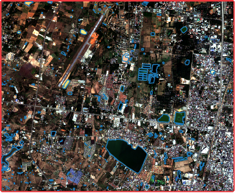
The objective of this research is to compare methods for determining the Normalized Difference Water Index (NDWI) and the Modified Normalized Difference Water Index (MNDWI) and resistance to urban and urban disturbances. From classification of visual information (Pixel-based) to extract surface water areas from Sentinel-2 satellite imagery. By checking for accuracy with the surface water area dragged the boundary from satellite imagery data from Google Earth found that the ideal Threshold of the NDWI Index is 0.1 and that of the MNDWI index is 0.35. Which is overall accurate at both 0.58, the MNDWI index was more efficient than the NDWI index.
Article Details

This work is licensed under a Creative Commons Attribution-NonCommercial-NoDerivatives 4.0 International License.
All authors need to complete copyright transfer to Journal of Applied Informatics and Technology prior to publication. For more details click this link: https://ph01.tci-thaijo.org/index.php/jait/copyrightlicense


References
วัชระ ดอนลาว และสวรินทร์ ฤกษ์อยู่สุข. (2563). การสกัดข้อมูลพื้นที่แหล่งน้ำบนภาพถ่ายดาวเทียมด้วยกูเกิลเอิร์ธเอนจิน. วารสารวิชาการเพื่อการพัฒนานวัตกรรมเชิงพื้นที่ (JSID), 1(2), 14–23. https://ph01.tci-thaijo.org/index.php/jsid/article/view/243981
ศรัญญา หารมาก และสรวิศ สุภเวชย์ (2562). การประมวลผลข้อมูลจากดาวเทียมเพื่อหาพื้นที่ที่มีศักยภาพพัฒนาเป็นแหล่งน้ำถาวร. [วิทยานิพนธ์, มหาวิทยาลัยเกษตรศาสตร์]. https://ethesis.lib.ku.ac.th/dspace/handle/123456789/137
โสลดา คงสังข์, จุติเทพ วงษ์เพ็ชร์ และชูพันธุ์ ชมภูจันทร์. (2562). การจำแนกพื้นที่ผิวน้ำจากข้อมูลภาพถ่ายดาวเทียม Landsat-8 OLI โดยใช้วิธีดัชนีน้ำแบบ NDWI. วารสารสมาคมสํารวจข้อมูลระยะไกลและสารสนเทศภูมิศาสตร์แห่งประเทศไทย, 20(ฉบับพิเศษ), 260–272.
Acharya, T.D., Subedi, A., & Lee, D.H. (2018). Evaluation of water indices for surface water extraction in a Landsat 8 scene of Nepal. Sensors, 18(2), 2580. https://doi.org/10.3390/S18082580
Beringer, A.L., Inmuong, Y., & Kaomuangnoi, K. (2018). Understanding urban vulnerabilities to climate change impacts in Khon Kaen and Mukdahan in Thailand. Social Science Asia, 4(4), 1–13. https://doi.org/10.14456/ssa.2018.28
Bijeesh, T.V., & Narasimhamurthy, K.N. (2020). Surface water detection and delineation using remote sensing images: A review of methods and algorithms. Sustainable Water Resources Management, 6, 68, 1–23. https://doi.org/10.1007/S40899-020-00425-4
Binary Thresholding function—ArcMap | Documentation. (n.d.). Retrieved October 9, 2021, Retrieved from https://desktop.arcgis.com/en/arcmap/latest/manage-data/raster-and-images/binary-thresholding-function.htm
Brodu, N. (2016). Super-resolving multiresolution images with band-independent geometry of multispectral pixels. IEEE Transactions on Geoscience and Remote Sensing, 55(8), 4610–4617. https://doi.org/10.1109/TGRS.2017.2694881
Chawla, I., Karthikeyan, L., & Mishra, A. K. (2020). A review of remote sensing applications for water security: Quantity, quality, and extremes. Journal of Hydrology, 585, 124826. https://doi.org/10.1016/J.JHYDROL.2020.124826
Drusch, M., Del Bello, U., Carlier, S., Colin, O., Fernandez, V., Gascon, F., & Bargellini, P. (2012). Sentinel-2: ESA’s optical high-resolution mission for GMES operational services. Remote Sensing of Environment, 120, 25–36. https://doi.org/10.1016/J.RSE.2011.11.026
Du, Y., Zhang, Y., Ling, F., Wang, Q., Li, W., & Li, X. (2016). Water bodies’ mapping from Sentinel-2 imagery with modified normalized difference water index at 10-m spatial resolution produced by sharpening the SWIR band. Remote Sensing, 8(4), 354. https://doi.org/10.3390/rs8040354
Huang, C., Chen, Y., Zhang, S., & Wu, J. (2018). Detecting, extracting, and monitoring surface water from space using optical sensors: A review. Reviews of Geophysics, 56(2), 333–360. https://doi.org/10.1029/2018RG000598
Ji, L., Zhang, L., & Wylie, B. (2009). Analysis of dynamic thresholds for the normalized difference water index. Photogrammetric Engineering and Remote Sensing, 75(11), 1307–1317. https://doi.org/10.14358/PERS.75.11.1307
Li, J., Pei, Y., Zhao, S., Xiao, R., Sang, X., & Zhang, C. (2020). A review of remote sensing for environmental monitoring in China. Remote Sensing, 12(7), 1130. https://doi.org/10.3390/RS12071130
Louis, J., Debaecker, V., Pflug, B., Main-Knorn, M., Bieniarz, J., Mueller-Wilm, U., & Gascon, F. (2016). Sentinel-2 Sen2Cor: L2A processor for users. in Living Planet Symposium (pp. 1–8).
McFeeters, S. K. (2007). The use of the normalized difference water index (NDWI) in the delineation of open water features. International Journal of Remote Sensing, 17(7), 1425–1432. https://doi.org/10.1080/01431169608948714
McHugh, M.L. (2012). Interrater reliability: The Kappa statistic. Biochemia Medica, 22(3), 276–282. https://doi.org/10.11613/bm.2012.031.
Ongsomwang, S., Pattanakiat, S. & Srisuwan, A. (2019). Impact of land use and land cover change on ecosystem service values: A case study of Khon Kaen city, Thailand. Environment and Natural Resources Journal, 17(4), 43–58. https://doi.org/10.32526/ENNRJ.17.4.2019.30
Otsu, N. (1979). A threshold selection method from gray-level histograms. IEEE Transactions on Systems, Man, and, Cybernetics, 9(1), 62–66.
Özelkan, E. (2020). Water body detection analysis using NDWI indices derived from Landsat-8 OLI. Polish Journal of Environmental Studies, 29(2), 1759–1769. https://doi.org/10.15244/PJOES/110447
Story, M., & Congalton, R. G. (1986). Accuracy assessment: A user’s perspective. Photogrammetric Engineering and Remote Sensing, 52(3), 397–399.
Tan, M.L., Tew, Y.L., Chun, K.P., Samat, N., Shaharudin, S.M., Mahamud, M.A., & Tangang, F.T. (2021). Improvement of the ESA CCI Land cover maps for water balance analysis in tropical regions: A case study in the Muda River Basin, Malaysia. Journal of Hydrology: Regional Studies, 36, 100837. https://doi.org/10.1016/J.EJRH.2021.100837
Topp, S.N., Pavelsky, T.M., Jensen, D., Simard, M., & Ross, M.R.V. (2020). Research trends in the use of remote sensing for inland water quality science: Moving towards multidisciplinary applications. Water, 12(1), 169. https://doi.org/10.3390/W12010169
Xu, H. (2007). Modification of normalised difference water index (NDWI) to enhance open water features in remotely sensed imagery. International Journal of Remote Sensing, 27(14), 3025–3033. https://doi.org/10.1080/01431160600589179
Yang, X., Zhao, S., Qin, X., Zhao, N., & Liang, L. (2017). Mapping of urban surface water bodies from Sentinel-2 MSI imagery at 10 m resolution via NDWI-Based image sharpening. Remote Sensing, 9(6), 596. https://doi.org/10.3390/RS9060596
