
Analysis of Burning Area from Forest Fire using Sentinel-2 image: A Case Study of Pai, Mae Hong Son Province
Article Sidebar
Main Article Content
Abstract
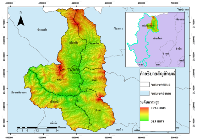
Forest fires are considered as a catastrophe that can cause great damage widely, some of which can occur spontaneously, or caused by human themselves, resulting in the air quality reduction. This research aims to find the risk and differentiate the specified area to assess the occurrence of forest fire in Pai district of Mae Hong Son, by using the data from Sentinel-2 Satellite between 2019 to 2020, in accordance with these indexes: Normalized Burn Ratio (NBR), Normalized Difference Water Index (NDWI) and Relativized Burn Ratio (RBR) to classify and validate the data from the field survey and interview from the locals. The result found that the risk areas in 2020 were higher than 2019, regarding to the district level, sub-district level, conserved forest and surrounding area. Based on 2019 data, there were a burnt area 6,315.03 rai of the district level, 4,177.72 rai of the conserved forest and there were 2,071.55 Rai of the surrounding area, most burnt area at the sub-district level were in Mueng Pang while the least burnt area was Wiang Tai sub-district. Regarding 2020 data, it showed that there was 10,253.15 rai burnt area of the district level, 5,810.11 rai of the conserved forest and 4,179.42 rai of the surrounding area. The validation in this study showed that 2019 data was at 86.42%. While 2020 data was at 87.86%
Article Details

This work is licensed under a Creative Commons Attribution-NonCommercial-NoDerivatives 4.0 International License.
All authors need to complete copyright transfer to Journal of Applied Informatics and Technology prior to publication. For more details click this link: https://ph01.tci-thaijo.org/index.php/jait/copyrightlicense


References
กรมอุทยานแห่งชาติสัตว์ป่า และพันธุ์พืช. (2560). ส่วนควบคุมไฟป่า กรมอุทยานแห่งชาติสัตว์ป่า และพันธุ์พืช. สืบค้น 26 พฤษภาคม 2560, สืบค้นจาก http://www.dnp.go.th/forestfire
กาญจน์เขจร ชูชีพ. (2018). การประเมินความถูกต้อง (Accuracy Assessment). Remote Sensing Technical Note No. 3. Faculty of Forestry, Kasetsart University.
จังหวัดแม่ฮ่องสอน. (2561). อำเภอปาย. สืบค้น 22 มิถุนายน 2563, สืบค้นจาก http://www.maehongson.go.th/th/province-info/administrative-region/pai.html
ณัฐพร ปานเหลือ. (2558). ปาย จ.แม่ฮ่องสอน. สืบค้น 22 มิถุนายน 2563, สืบค้นจาก https://sites.google.com/site/paymaehongsorn/
พิจิตรา พะยิ้ม. (2562). การเปรียบเทียบการกระจายตัวของจุดความร้อนที่ตรวจวัดได้ระหว่าง MODIS C6 กับ VIIRS ในพื้นที่อำเภอลานสัก จังหวัดอุทัยธานี. [ปริญญานิพนธ์ มหาวิทยาลัยนเรศวร].
วิภารัตน์ อัมพะวัน. (2561). การศึกษาเทคนิคการประมาณสภาพกายภาพต้นยางพารา จากข้อมูล อากาศยานไร้คนขับ. [ปริญญานิพนธ์ มหาวิทยาลัยนเรศวร].
ศศิธร ฉัตรสุดารัตน์. (2560). การศึกษาและวิเคราะห์การปลดปล่อยก๊าซเรือนกระจกในพื้นที่ปลูกอ้อย โดยเทคนิคการจำแนกเชิงวัตถุจากข้อมูลภาพถ่ายดาวเทียม Landsat : กรณีศึกษา อำเภอไทรงาม จังหวัดกำแพงเพชร. [ปริญญานิพนธ์ มหาวิทยาลัยนเรศวร].
สุภาสพงษ์ รู้ทํานอง. (2560). การสกัดและประเมินพื้นที่ถูกเผาไหม้โดยใช้ค่าความแตกต่างของดัชนีเชิงคลื่นหลายช่วงเวลา จากข้อมูลแลนด์แซท 8 : กรณีศึกษา อุทยานแห่งชาติคลองวังเจ้า คลองลานและแม่วงก์. วารสารมนุษยศาสตร์และสังคมศาสตร์ (สทสม.), 25(2). 49-65.
หทัยทิพย์ เงินอิน. (2561). การหาปริมาณการกักเก็บคาร์บอนของสวนสักด้วยอากาศยานไร้คนขับในพื้นที่ตำบลวังนกแอ่น อำเภอวังทอง จังหวัดพิษณุโลก. [ปริญญานิพนธ์ มหาวิทยาลัยนเรศวร].
อมร เพ็ชรสว่าง. (2015). แผนที่ความชื้นจากข้อมูลดาวเทียม. สืบค้น 22 มิถุนายน 2563, สืบค้นจาก https://www.gistda.or.th/main/th/node/802
อุไรรัตน์ อุ่นเมือง. (2562). การพัฒนาอัลกอริทึ่มเพื่อการตรวจนับจำนวนไม้ผลแบบอัตโนมัติ ด้วยข้อมูลภาพถ่ายจากอากาศยานไร้คนขับ. [ปริญญานิพนธ์ มหาวิทยาลัยนเรศวร].
ESA. (2018). SNAP. Retrieved 11 November 2020, Retrieved from https://step.esa.int/main/toolboxes/snap/
HUMBOLDT STATE GEOSPATIAL ONLINE. (2014). Normalized Burn Ratio. Retrieved 11 November 2020, Retrieved from http://gsp.humboldt.edu/OLM/Courses/GSP_216_Online/lesson5-1/NBR.html
