
Integrating low-cost hydroacoustic surveying for canal sedimentation monitoring: a case study from southern Thailand
Article Sidebar
Main Article Content
Abstract
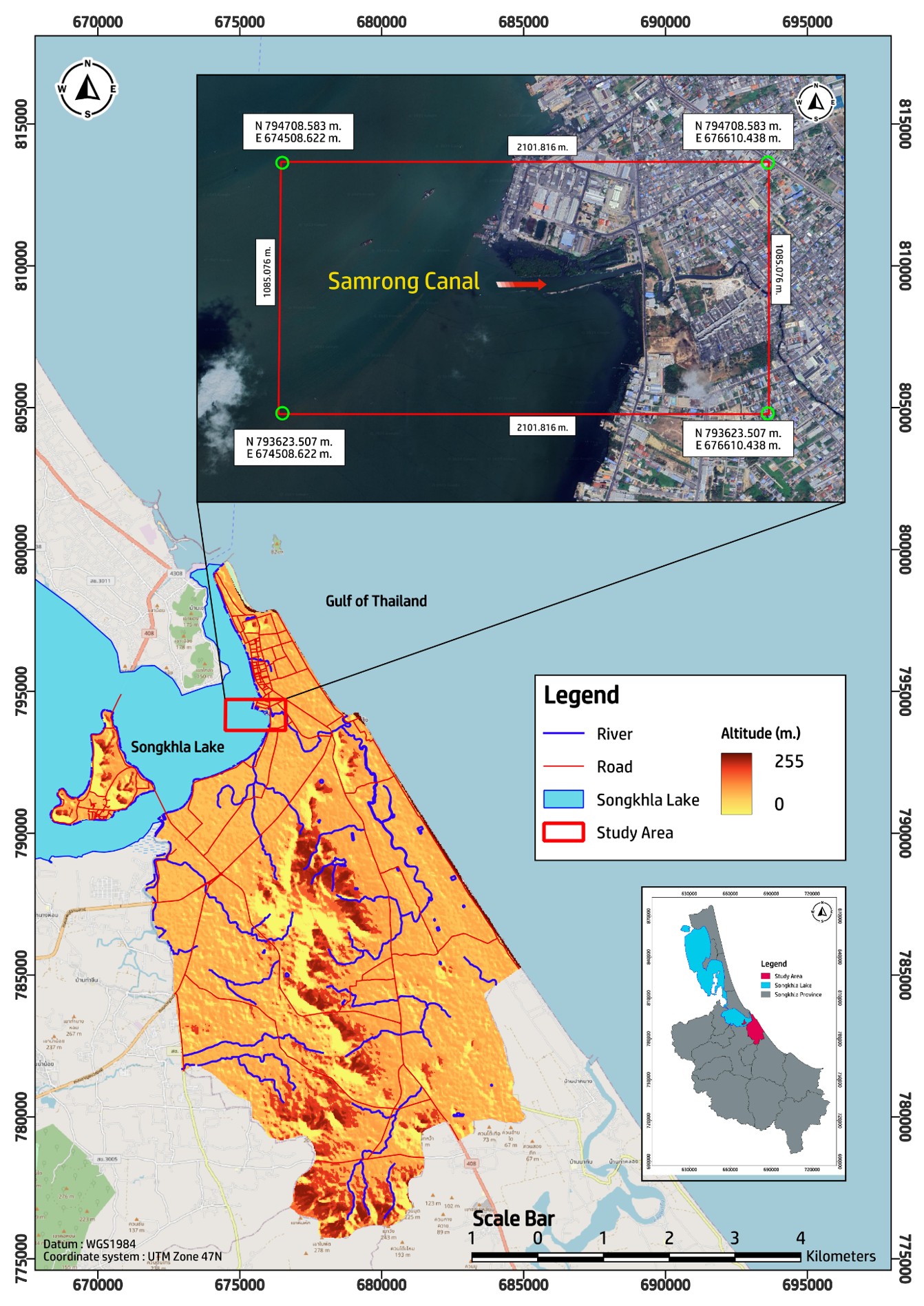
Efficient sedimentation monitoring is vital for maintaining navigability and hydraulic performance in canal systems, yet conventional hydrographic surveys remain costly and logistically demanding. This study integrates a low-cost hydroacoustic surveying method using a recreational-grade single-beam echosounder to provide cost-effective and practical solution for canal sedimentation management. The approach was first validated in Songkhla Lake, representing mixed freshwater, brackish, and saline conditions, and subsequently applied to the Samrong Canal in southern Thailand as a real-world case study. Controlled experiments compared echosounder-derived depths with reference measurements to evaluate vertical accuracy under different water types following the International Hydrographic Organization (IHO) S-44 Special Order criteria. Results showed a standard deviation (SD) of 0.05 m and RMSE₉₅ = 0.14 m in controlled settings, with no statistically significant effect of water type on accuracy. Semi-controlled field surveys yielded SD values of ±0.06 m (fresh), ±0.05 m (brackish), and ±0.09 m (saline), all within the IHO tolerance limits. The validated setup was then applied for 0.5-m contour bathymetric mapping in Samrong Canal, successfully delineating shoaling zones and siltation hotspots critical for maintenance planning. The findings demonstrate that integrating low-cost echosounders into canal monitoring workflows can produce IHO compliant, high-utility bathymetric data, offering a scalable and cost-effective alternative for sedimentation assessment in shallow tropical waterways.
Article Details

This work is licensed under a Creative Commons Attribution-NonCommercial-NoDerivatives 4.0 International License.

This work is licensed under a Creative Commons Attribution-NonCommercial-NoDerivatives 4.0 International License.
References
Bateman S. Hydrographic surveying in the EEZ: differences and overlaps with marine scientific research. Marine Policy, 2005;29(2):163-74. DOI: https://doi.org/10.1016/j.marpol.2004.08.011
Ferretti R, Fumagalli E, Caccia M, Bruzzone G. Seabed classification using a single beam echosounder. Oceans 2015-Genova; 2015 May 18-19; Genova, Italy. USA: IEEE; 2015. p. 1-5. DOI: https://doi.org/10.1109/OCEANS-Genova.2015.7271709
Sánchez-Carnero N, Aceña S, Rodríguez-Pérez D, Couñago E, Fraile P, Freire J. Fast and low-cost method for VBES bathymetry generation in coastal areas. Estuarine Coastal Shelf Sci. 2012;114:175-82. DOI: https://doi.org/10.1016/j.ecss.2012.08.018
Schimel ACG, Ierodiaconou D, Hulands L, Kennedy DM. Accounting for uncertainty in volumes of seabed change measured with repeat multibeam sonar surveys. Cont Shelf Res. 2015;111:52-68. DOI: https://doi.org/10.1016/j.csr.2015.10.019
O'Hara Murray RB, Gallego A. Data review and the development of realistic tidal and wave energy scenarios for numerical modelling of Orkney Islands waters, Scotland. Ocean Coast Manag. 2017;147:6-20. DOI: https://doi.org/10.1016/j.ocecoaman.2017.03.011
Entwistle N, Heritage G, Milan D. Recent remote sensing applications for hydro and morphodynamic monitoring and modelling. Earth Surf Processes Landforms. 2018;43:2283-91. DOI: https://doi.org/10.1002/esp.4378
Kachelriess D, Wegmann M, Gollock M, Pettorelli N. The application of remote sensing for marine protected area management. Ecol Indic. 2014;36:169-77. DOI: https://doi.org/10.1016/j.ecolind.2013.07.003
Kulawiak M, Chybicki A. Application of Web-GIS and geovisual analytics to monitoring of seabed evolution in South Baltic Sea coastal areas. Mar Geod. 2018;41(4):405-26. DOI: https://doi.org/10.1080/01490419.2018.1469557
El-Hattab AI. Single beam bathymetric data modelling techniques for accurate maintenance dredging. Egypt J Remote Sens Space Sci. 2014;17(2):189-95. DOI: https://doi.org/10.1016/j.ejrs.2014.05.003
Thomas F, Livio FA, Ferrario F, Pizza M, Chalaturnky R. A review of subsidence monitoring techniques in offshore environments. Sensors. 2024;24(13):4164. DOI: https://doi.org/10.3390/s24134164
Bio A, Gonçalves JA, Magalhães A. Pinheiro J, Bastos L. Combining low-cost sonar and high-precision global navigation satellite system for shallow water bathymetry. Estuaries Coasts. 2022;(45)4:1000-11. DOI: https://doi.org/10.1007/s12237-020-00703-6
Monteys X, Harris P, Caloca S, Cahalane C. Spatial prediction of coastal bathymetry based on multispectral satellite imagery and multibeam data. Remote Sens. 2015;7(10):13782-806. DOI: https://doi.org/10.3390/rs71013782
Okabe T, Aoki SI, Kato S. Potentiality of bathymetry monitoring using fish finder data for sediment management in a wide area. 5th International Conference on APAC 2009; 2009 Oct 13-16; Nanyang Avenue, Singapore. Singapore: World Scientific Publishing; 2010. p. 328-34. DOI: https://doi.org/10.1142/9789814287951_0088
Theparoonrat Y, Miyamoto Y, Sasakura T, Uchida K, Minlee Y, Anongponyoskun M, et al. Development and improvement of acoustic equipments and system for fisheries resources survey in shallow area. SEAFDEC Technical Seminar 2014; Samut Prakan, Thailand. Thailand: SEAFDEC/TD Institutional Repository; 2014. p. 2-6.
Mcinnes AM, Khoosal A, Murrell A, Merkle D, Lacerda M, Nyengera R, et al. Recreational fish-finders—an inexpensive alternative to scientific echo-sounders for unravelling the links between marine top predators and their prey. PLoS One. 2015;10(11):e0140936. DOI: https://doi.org/10.1371/journal.pone.0140936
Uchida K, Miyamoto Y, Takeda S, Tokai T, Kakihara T, Shiode D. A facile method for mapping bathymetric chart at shallow coastal water by using GPS and fish finder. Fish Eng. 2008;45(2):93-100. (In Japanese)
Firsov YG. Modern digital hydrography and the new international hydrographic organization bathymetric survey standards. Vestn Gos Univ Morsk Rech Flota im adm SO Makarova. 2024;16(1):17-36. DOI: https://doi.org/10.21821/2309-5180-2024-16-1-17-36
Elsobeiey M. Performance analysis of low-cost single-frequency GPS receivers in hydrographic surveying. Int Arch Photogramm Remote Sens Spat Inf Sci. 2017;XLII-4/W5:67-71. DOI: https://doi.org/10.5194/isprs-archives-XLII-4-W5-67-2017
Kearns TA, Breman J. Bathymetry-the art and science of seafloor modeling for modern applications. In: Breman J, Editor. Ocean globe. USA: Environmental Systems Research Institute; 2010. p. 1-36.
Sac H, Leblebicioğlu MK, Akar G. 2D high-frequency forward-looking sonar simulator based on continuous surfaces approach. Turk J Electr Eng Comput Sci. 2015;23(7):2289-303. DOI: https://doi.org/10.3906/elk-1305-188
Kartal SK, Hacıoğlu R, Görmüş KS, Kutoğlu ŞH, Leblebicioğlu MK. Modeling and analysis of sea-surface vehicle system for underwater mapping using single-beam echosounder. J Mar Sci Eng. 2022;10(10):1349. DOI: https://doi.org/10.3390/jmse10101349
Garmin Ltd. GPSMAP 585 Plus Owner’s Manual [Internet]. Olathe (KS): Garmin; 2017 [cited 2025 Jul 19]. Available from: http://www.garmin.com.
Helminen J, Linnansaari T, Bruce M, Dolson-Edge R, Curry RA. Accuracy and precision of low-cost echosounder and automated data processing software for habitat mapping in a large river. Diversity. 2019;11(7):116. DOI: https://doi.org/10.3390/d11070116
Halmai Á, Gradwohl–Valkay A, Czigány S, Ficsor J, Liptay ZÁ, Kiss K, et al. Applicability of a recreational-grade interferometric sonar for the bathymetric survey and monitoring of the Drava River. ISPRS Int J Geo-Inf. 2020;9(3):149. DOI: https://doi.org/10.3390/ijgi9030149
Gabuyo MRP, Siringan FP. Utility of low-cost recreational-grade echosounders in imaging and characterizing bubbly coastal submarine groundwater discharge. J Hydrol X. 2022;14:100118. DOI: https://doi.org/10.1016/j.hydroa.2021.100118
