Exploring Google Earth Engine, Machine Learning, and GIS for Land Use Land Cover Change Detection in the Federal Capital Territory, Abuja, between 2014 and 2023
Article Sidebar
Main Article Content
Abstract
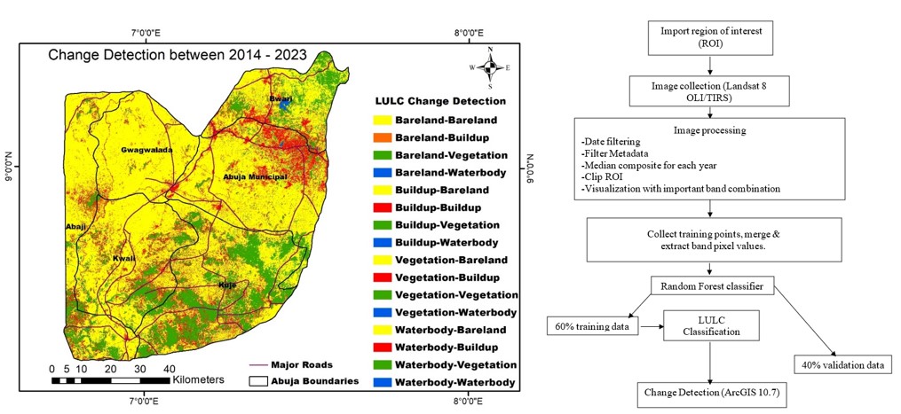
This study aims to visualize various land use land cover (LULC) classes, estimate the net change in LULC types between the years 2014 and 2023, and use transition mapping to track LULC transitions within waterbody, vegetation, bareland, and buildup to better understand how land use types change from one another. Google Earth Engine (GEE), Random Forest (RF), and Geographic Information System (GIS) were used for LULC classification and change detection. The dataset employed for this study is Landsat-8 with 30 m resolution, and four land cover classes, which include waterbody, vegetation, bareland, and buildup, were classified for this study using RF. The training samples for each class were divided into two groups: 60% were used for LULC classification, and 40% were used for accuracy assessment. The overall accuracy (OA) for 2014 and 2023 was 91% and 92%, while the Koppa coefficient (KC) for 2014 and 2023 was 0.88% and 0.89% giving validation to the quality and reliability of this research. The result showed that between 2014 and 2023, waterbody increased from 27.56 km2 to 36.67 km2, vegetation cover decreased from 3,153.73 km2 to 1,283.62 km2, bareland increased from 3,660.74 km2 to 4,845.30 km2, and buildup area increased from 541.21 km2 to 1,217.69 km2. The transition results show that vegetation cover is being rapidly replaced by bareland and buildup. The results of this study are crucial for directing land use planning in Abuja and other developing regions of the world to enhance sustainable urban expansion. To help the government and policymakers support sustainable development, further research should be conducted to deepen the understanding of urban growth and its consequences.
Article Details

This work is licensed under a Creative Commons Attribution-NonCommercial 4.0 International License.
Published articles are under the copyright of the Applied Environmental Research effective when the article is accepted for publication thus granting Applied Environmental Research all rights for the work so that both parties may be protected from the consequences of unauthorized use. Partially or totally publication of an article elsewhere is possible only after the consent from the editors.
References
Wulder, M.A., Joanne, C.W., Thomas, R.L, Curtis, E.W., Alan, S.B., Warren, B.C., Eugene, A.F., Jerad Shaw, Jeffrey, G.M., David P.R. The global Landsat archive: Status, consolidation, and direction. Remote Sensing of Environment, 2016, 185, 271-283.
Enoguanbhor, E.C., Gollnow, F., Nielsen, J.O., Lakes, T., Walker, B.B. Land cover change in the Abuja City-Region, Nigeria: Integrating GIS and remotely sensed data to support land use planning. Sustainability, 2019, 11(5), 1313.
Wan, B., Guo, Q., Fang, F., Su, Y., Wang, R. Mapping US urban extents from MODIS data using one-class classification method. Remote Sensing, 2015, 7(8), 10143-10163.
Kumar, L., Mutanga, O. Remote sensing of above-ground biomass. Remote Sensing, 2017, 9(9), 935.
Nasiri, V., Deljouei, A., Moradi, F., Sadeghi, S.M.M., Borz, S.A. Land use and land cover mapping using Sentinel-2, Landsat-8 Satellite Images, and Google Earth Engine: A comparison of two composition methods. Remote Sensing, 2022, 14(9), 1977.
Gorelick, N., Hancher, M., Dixon, M., Ilyushchenko, S., Thau, D., Moore, R. Google Earth Engine: Planetary-scale geospatial analysis for everyone. Remote sensing of Environment, 2017, 202, 18-27.
Rabiei-Dastjerdi, H., Mohammadi, S., Saber, M., Amini, S., McArdle, G. Spatiotemporal analysis of NO2 production using TROPOMI time-series images and Google Earth Engine in a middle eastern country. Remote Sensing, 2022, 14(7), 1725.
Tamiminia, H., Salehi, B., Mahdianpari, M., Quackenbush, L., Adeli, S., Brisco, B. Google Earth Engine for geo-big data applications: A meta-analysis and systematic review. ISPRS Journal of Photogrammetry and Remote Sensing, 2020, 164, 152-170.
Kar, R., Reddy, G.O., Kumar, N., Singh, S.K. Monitoring spatio-temporal dynamics of urban and peri-urban landscape using remote sensing and GIS–A case study from Central India. The Egyptian journal of remote sensing and space science, 2018, 21(3), 401-411.
Ermida, S.L., Soares, P., Mantas, V., Göttsche, F.M., Trigo, I.F. Google earth engine open-source code for land surface temperature estimation from the landsat series. Remote Sensing, 2020, 12(9), 1471.
Roy, P. S., Roy, A. Land use and land cover change in India: Aremote sensing & GIS prespective. Journal of the Indian Institute of Science, 2010, 90(4), 489-502.
Wassie, S.B. Natural resource degradation tendencies in Ethiopia: a review. Environmental systems research, 2020, 9(1), 1-29.
Hashem, N., Balakrishnan, P. Change analysis of land use/land cover and modelling urban growth in Greater Doha, Qatar. Annals of GIS, 2015, 21(3), 233-247.
Fabolude, G., Aighewi, I.T. Evaluation of the Extent of Land Use-Land Cover Changes of Benin City, Edo State, Nigeria from 1987-2019. Journal of Applied Sciences and Environmental Management, 2022, 26(8), 1443-1450.
Aigbokhan, O.J., Ofordu, C.S., Essien, N.E., MbaEssien, N.C. Land cover accuracy assessment in Okitipupa, Ondo State, Nigeria; application of atmospheric correction and machine learning algorithms. Journal of Meteorology and Climate Science, 2022, 21(1), 29-53.
Halder, A., Ghosh, A., & Ghosh, S. Supervised and unsupervised landuse map generation from remotely sensed images using ant based systems. Applied Soft Computing, 2011, 11(8), 5770-5781.
Ma, L., Liu, Y., Zhang, X., Ye, Y., Yin, G., Johnson, B.A. Deep learning in remote sensing applications: A meta-analysis and review. ISPRS journal of photogrammetry and remote sensing, 2019, 152, 166-177.
Shih, H.C., Stow, D.A., Tsai, Y.H. Guidance on and comparison of machine learning classifiers for Landsat-based land cover and land use mapping. International Journal of Remote Sensing, 2019, 40(4), 1248-1274.
Maxwell, A.E., Warner, T.A., Fang, F. Implementation of machine-learning classification in remote sensing: An applied review. International journal of remote sensing, 2018, 39(9), 2784-2817.
Carranza-García, M., García-Gutiérrez, J., Riquelme, J.C.A framework for evaluating land use and land cover classification using convolutional neural networks. Remote Sensing, 2019, 11(3), 274.
Ohiambe, E., Home, P.G., Coker, A.O., Sang, J. Assessing the surface rainwater harvesting potential for Abuja, Nigeria: a short-term projection. Nigerian Journal of Technological Development, 2019, 16(2), 63-70.
Ekwe, M.C., Ibrahim, A.T., Balogun, I.A., Adedeji, O. I., Ekwe, D.O., Nom, J. Assessment of Urban Cooling Island Effects of Jabi Lake Reservoir, Abuja on its Surrounding Microclimate using Geospatial Techniques, 2019, 19 (2), 1-10.
Chibuike, E.M., Ibukun, A.O., Abbas, A., Kunda, J.J. Assessment of green parks cooling effect on Abuja urban microclimate using geospatial techniques. Remote Sensing Applications: Society and Environment, 2018, 11, 11-21.
Jin, Y., Liu, X., Chen, Y., Liang, X. Land-cover mapping using Random Forest classification and incorporating NDVI time-series and texture: A case study of central Shandong. International journal of remote sensing, 2018, 39(23), 8703-8723.
Huynh-Cam, T.T., Chen, L.S., Le, H. Using decision trees and random forest algorithms to predict and determine factors contributing to first-year university students’ learning performance. Algorithms, 2021, 14(11), 318.
Phinzi, K., Ngetar, N.S., Pham, Q.B., Chakilu, G.G., Szabó, S. Understanding the role of training sample size in the uncertainty of high-resolution LULC mapping using random forest. Earth Science Informatics, 2023, 1-11.
Kadri, N., Jebari, S., Augusseau, X., Mahdhi, N., Lestrelin, G., Berndtsson, R. Analysis of Four Decades of Land Use and Land Cover Change in Semiarid Tunisia Using Google Earth Engine. Remote Sensing, 2023, 15(13), 3257.
Vilasan, R., kapse, V. Monitoring spatio-temporal dynamics of land use/land cover changes using Remote Sensing and GIS–a case study of Ernakulam District, India. Applied Ecology & Environmental Research, 2022, 20(4), 3353-3366.
World Population Review. Abuja Population, 2022. [Online] Available from https://worldpopulationreview.com/world-cities/abuja-population. [Accessed 1 October 2023].
Odjugo, P.A., Enaruvbe, G.O., Isibor, H.O. Geospatial approach to spatio-temporal pattern of urban growth in Benin City, Nigeria. African Journal of Environmental Science and Technology, 2015, 9(3), 166-175.
Rasool, R., Fayaz, A., ul Shafiq, M., Singh, H., Ahmed, P. Land use land cover change in Kashmir Himalaya: Linking remote sensing with an indicator based DPSIR approach. Ecological Indicators, 2021, 125, 107447.
Musa, A., Jacob, O.N. Evaluation of challenges facing planning of special education in FCT, Abuja, Nigeria. European Journal of Humanities and Educational Advancements, 2021, 2(3), 31-37.
Akpu, B., Tanko, A., Jeb, D., Dogo, B. Geospatial Analysis of Urban Expansion and Its Impact on Vegetation Cover in Kaduna Metropolis, Nigeria. Asian Journal of Environment & Ecology, 2017, 3(2), 1-11.
Owoeye, J. O., Ibitoye, O. A. Analysis of Akure urban land use change detection from remote imagery perspective. Urban Studies Research, 4673019.
Ibrahim Mahmoud, M., Duker, A., Conrad, C., Thiel, M., Shaba Ahmad, H. Analysis of settlement expansion and urban growth modelling using geoinformation for assessing potential impacts of urbanization on climate in Abuja City, Nigeria. Remote Sensing, 2016, 8(3), 220.
Hassan, M.M. Monitoring land use/land cover change, urban growth dynamics and landscape pattern analysis in five fastest urbanized cities in Bangladesh. Remote Sensing Applications: Society and Environment, 2017, 7, 69-83.
Fanan, U., Dlama, K.I., Oluseyi, I.O. Urban expansion and vegetal cover loss in and around Nigerias Federal Capital City. Journal of Ecology and the Natural Environment, 2011, 3(1), 1-10.
Moges, D.M., Bhat, H.G. An insight into land use and land cover changes and their impacts in Rib watershed, north‐western highland Ethiopia. Land degradation & development, 2018, 29(10), 3317-3330.
