
The Student Geographic Information System for Support Consideration of Student Loans
Article Sidebar
Main Article Content
Abstract
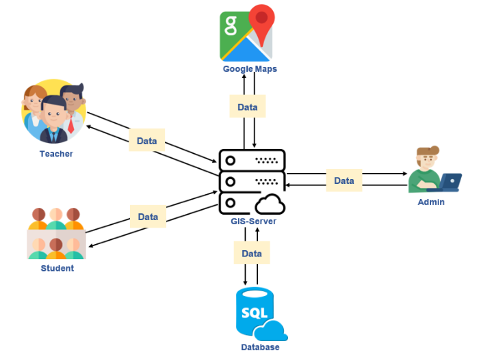
The aim of this research was to design, develop and assess efficacy and satisfaction of the student geographic information system for support consideration of student loan. The database system to support considerations of student loan and display student information, location on maps. The sample size in this study was determined by a random sampling consisting of 5 experts, professor and students in business computer program 120. The research results were as follows: the student geographic information system for support consideration of student loan is divided into three main 1) students manage of personal information, profile image, address and home image 2) professor can view student summary report in graph by province and student’s information via Google Maps and 3) administrator insert, update, delete information and all. The assess efficacy of the student geographic information system for support consideration of student loan from the experts were as follows: the system security, system usage and system function is also at highest level. The assess satisfaction of the professor and students with the student geographic information system for support consideration of student loan the results were as also at highest level.
Article Details

This work is licensed under a Creative Commons Attribution-NonCommercial-NoDerivatives 4.0 International License.
All authors need to complete copyright transfer to Journal of Applied Informatics and Technology prior to publication. For more details click this link: https://ph01.tci-thaijo.org/index.php/jait/copyrightlicense


References
กองทุนเงินให้กู้ยืมเพื่อการศึกษา (กยศ.). (2561). ความเป็นมากองทุนเงินให้กู้ยืมเพื่อการศึกษา (กยศ.). Retrieved from กองทุนเงินให้กู้ยืมเพื่อการศึกษา (กยศ.). สืบค้น 18 พฤศจิกายน 2563), สืบค้นจาก https://www.studentloan.or.th
ตัสนีม กอแตง. (2556). ผลของการเรียนผ่านห้องเรียนเสมือนจริงที่สร้างตามทฤษฎีการเรียนรู้โดยใช้สมองเป็นฐานสำหรับนักศึกษาระดับปริญญาตรี มหาวิทยาลัยสงขลานครินทร์ วิทยาเขตปัตตานี. [วิทยานิพนธ์ปริญญามหาบัณฑิต มหาวิทยาลัยสงขลานครินทร์ วิทยาเขตปัตตานี].
ปานจิตร์ หลงประดิษฐ์ และสุรสีห์ น้อยมหาไวย. (2559). แอพพลิเคชันรับรู้และแสดงตำแหน่งสถานที่ท่องเที่ยวจังหวัดเพชรบุรีตามการจำแนกกลุ่มของผู้ใช้ด้วยกูเกิ้ลแมพเอพีไอ บนมือถือระบบแอนดรอยด์. วารสารวิชาการการจัดการเทคโนโลยีสารสนเทศและนวัตกรรม, 3(1), 71-79.
รสลิน เพตะกร. (2561). ระบบสารสนเทศทางภูมิศาสตร์เพื่อจัดการข้อมูลภูมิปัญญาท้องถิ่น กรณีศึกษาเทศบาลเมืองเมืองแกนพัฒนา อำเภอแม่แตง จังหวัดเชียงใหม่. รายงานวิจัยฉบับสมบูรณ์ มหาวิทยาลัยรัชภัฏเชียงใหม่
ศูนย์วิจัยภูมิสารสนเทศเพื่อประเทศไทย. (2562, มกราคม 17). ความหมายของคำว่า "ระบบสารสนเทศภูมิศาสตร์". Retrieved from ศูนย์วิจัยภูมิสารสนเทศเพื่อประเทศไทย. สืบค้น 17 มกราคม 2563, สืบค้นจาก http://www.gisthai.org
สิทธิพร พรอุดมทรัพย์. (2561). การพัฒนาเว็บไซต์การพาณิชย์อิเล็กทรอนิกส์ด้วยความเป็นจริงเสริมและการสำรวจความพึงพอใจผู้ใช้งาน กรณีศึกษาระบบทดลองเสื้อผ้าซิ่นตีนจกเสมือนจริง. วารสารมหาวิทยาลัยราชภัฏธนบุรี, 12(1), 37-53.
สิทธิพร พรอุดมทรัพย์. (2561). การพัฒนาเว็บไซต์การพาณิชย์อิเล็กทรอนิกส์ด้วยความเป็นจริงเสริมและการสำรวจความพึงพอใจผู้ใช้งาน กรณีศึกษาระบบทดลองเสื้อผ้าซิ่นตีนจกเสมือนจริง. วารสารมหาวิทยาลัยราชภัฏธนบุรี, 12(1), 37-53.
อัตภาพ มณีเติม และคณะ. (2563). การพัฒนาระบบสารสนเทศทางภูมิศาสตร์ แหล่งเพาะปลูกพืชและไม้ผลเพื่อการผลิตอาหารและการท่องเที่ยวเชิงเกษตร จังหวัดเพชรบุรี. วารสารวิทยาการสารสนเทศและเทคโนโลยีประยุกต์, 2(1), 1-18.
อาคีรา ราชเวียง. (2561). การพัฒนาระบบสารสนเทศทางภูมิศาสตร์เพื่อส่งเสริมอุตสาหกรรมท่องเที่ยวลุ่มแม่น้ำท่าจีน. วารสารวิชาการมหาวิทยาลัยธนบุรี, 12(28), 37-51.
Akanbi, A.K, & Agunbiade, O.Y. (2013). Integration of a city GIS data with Google Map API and Google Earth API for a web based 3D geospatial application. International Journal of Science and Research, 2(11).
Narkdee, N. (2018). การใช้งาน google map API. Retrieved 14 January 2020, Retrieved from http://www.ninenik.com
