
Traffic Less Navigation with Haversine Formula and RPA Algorithm
Article Sidebar
Main Article Content
Abstract
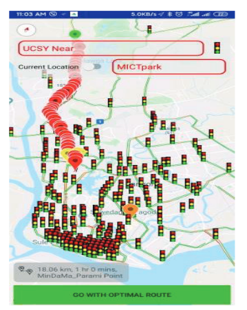
The system uses a geographic information system to analyze and monitor traffic congestion and use GPS data for public transport planning in Yangon, Myanmar. The system provides accurate maps for estimating traffic conditions more efficiently from GPS data, saving more time. A system that displays changes in the position, speed, and direction of vehicles traveling on the streets of Yangon using traffic speeds and route pattern algorithms. The established centralized GPS server database infrastructure provides any kind of analysis that requires GPS traffic data stored in a distributed client-server environment. In this system, a statement of user desired traffic jams between the source and destination is estimated and the results are presented with a Map. This system is for analyzing traffic data, avoiding traffic congestion and obtaining optimal routes with a modified A * algorithm. GPS data (current location) and user search area using the K-d tree and Haversine algorithm are required. Second, look for traffic jam data with Google's traffic layer and the routing matrix pattern algorithm. Finally, Analysis the traffic by Smart-A* and then show the result of traffic congestion statement and best optimal route. In the case, there are three main components: Data Collection, Data Extraction and Implementation. And this is Client-Server database system that storing the data and server in the cloud Virtual Machine (VM).
Article Details

This work is licensed under a Creative Commons Attribution-NonCommercial-NoDerivatives 4.0 International License.
All authors need to complete copyright transfer to Journal of Applied Informatics and Technology prior to publication. For more details click this link: https://ph01.tci-thaijo.org/index.php/jait/copyrightlicense


References
Amin, A. & Uddin, R. (2015). Real time traffic monitoring system using crowd sourced GPS data. [Bachelor of science in computer and engineering: BRAC University]. http://dspace.bracu.ac.bd/xmlui/handle/10361/4380
Brose, C. A. (n.d.). Geographic information systems for spatial analysis of traffic collision locations in La crosse, Saint Mary’s University of Minnesota, 1-11.
Costanzo, A. (2013). Using GPS data to monitor road traffic flows in a metropolitan area: Methodology and case study. In Proceedings of the 2nd International Conference on Computer Science and Electronics Engineering (ICCSEE) (pp. 1481-1485). Atlantis Press.
ESRI (n.d.). GIS solutions for highway and roadway management. Retrieved 13 December 2019, Retrieved from https://www.esri.com/content/dam/esrisites/sitecore-archive/Files/Pdfs/library/brochures/pdfs/gis-sols-for-highway.pdf
ESRI (n.d.). GIS for Transportation Infrastructure Management. Retrieved 13 December 2019, Retrieved from https://www.esri.com/~/media/files/pdfs/library/brochures/pdfs/transportation-infrastructure.pdf
Furht, B. (2010). Cloud computing fundamentals. Springer. https://doi.org/10.1007/978-1-4419-6524-0_1
Goh, C.H., Lu, H., Ooi, B.-C., & Tan K.-L. (1996). Indexing temporal data using existing B+-trees. Data & Knowledge Engineering, 18, 147-165.
Jannik, J. (1995). Implementing deletion in B+trees. ACM SIGMOD Record, 24(1), 33-38.
JICA (2013). Yangon 2040, the peaceful and beloved Yangon, - A city of green and gold -, The strategic urban development plan of the greater Yangon. Retrieved 10 December 2019, Retrieved from https://www.jica.go.jp/activities/issues/urban/ku57pq000019fbsv-att/myanmar_01en.pdf
Otair, M. (2013). Approximate K-nearest neighbour based spatial clustering using K-D tree. International Journal of Database Management Systems, 5(1), 97-108. https://doi.org/10.5121/ijdms.2013.5108
Rahane, S.K., Saharkar, U.R., & Patil, D.Y. (). Technique identification for road traffic congestion solution in Talegaon Dabhade state highway-55. Journal of Information, Knowledge and Research in Civil Engineering, 3(1).
Sofia, A.S., Nithyaa, R., Arulraj, J.G.P. (2013). Minimizing the traffic congestion using GIS. International Journal of Research in Engineering & Advanced Technology, 1(1), 1-6.
Stern, H. (2002). Nearest neighbour matching using KD-trees. [Bachelor of computer science: Dalhousie University].
Yu, C., Bailey, J., Montefusco, J., Zhang, R. & Zhong, J. (2010). Enhancing the B+-tree by dynamic node popularity caching, 110(7), 268-273. https://doi.org/10.1016/j.ipl.2010.01.008
