
The Development of Geographic Information Systems for Crop Cultivation and Food Production and Agricultural Tourism in Phetchaburi Province
Article Sidebar
Main Article Content
Abstract
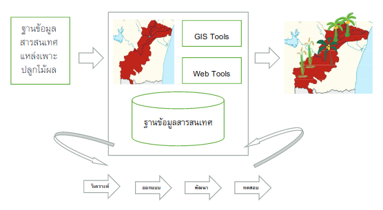
The objectives of this research were to: 1) Design and develop geographic information systems for the cultivation of plants and fruit trees for food production and agricultural tourism Phetchaburi Province. 2) Assess the quality of the geographic information system for the cultivation of plants and fruit trees for food production and agricultural tourism Phetchaburi Province. Tools and methods applied in the spiral model of system development life cycle (SDLC). The users of the information system consist farmers, agricultural district administrators, agricultural promotion officers, and local government administration who cultivate crops and fruit trees. Which from a simple random method in Phetchaburi Province. The research results were as follows: 1) The development of geographic information systems for crop cultivation and food production and agricultural tourism is at least 7 modules 28 functions. Showing geographical information, amount 3 base map is road route, provincial boundary and district boundary. The layer map shows the geographical position of plants and fruit trees. 10 layers are rice, bananas, coconuts, lemons, sugarcane, sugar cane, durian and vegetables. The map layer shows the geographical position of animal farms 4 layers (layers) are pigs, chickens, cows, and ducks. Map showing the position of plant and animal diseases 1 layer. Set the right for farmer, academic officers promoting agriculture, agricultural district/provincial administration and local administrative organizations to access different permissions. 2) The results of the quality evaluation of geographic information systems for crop and fruit plantation. To accuracy, easy understanding, has benefits for management and able to be used to manage. General users of farmers at high level (Mean = 3.523, S.D. = 1.061). The administrator of the agricultural academics was at a high level at the mean level (Mean = 3.628, S.D. = 1.016). The quality of use, report display and information presentation at high level (Mean = 3.514, S.D. = 1.078). And the overall quality in every aspect is at a high level (Mean = 3.562, S.D. = 1.050). Suggestions for data on each side of the plant that is diverse in each area. And implement a web chat.
Article Details

This work is licensed under a Creative Commons Attribution-NonCommercial-NoDerivatives 4.0 International License.
All authors need to complete copyright transfer to Journal of Applied Informatics and Technology prior to publication. For more details click this link: https://ph01.tci-thaijo.org/index.php/jait/copyrightlicense


References
กรมส่งเสริมการเกษตร. (2560). แบบคำร้องการทะเบียนเกษตรกร ของกระทรวงเกษตรและสหกรณ์. สืบค้น 10 สิงหาคม 2559, สืบค้นจาก http://farmer.doae.go.th/farmerform.pdf
กิตติพงษ์ กลมกล่อม. (2552). การวิเคราะห์และออกแบบระบบเชิงวัตถุด้วย UML. สำนักพิมพ์ เคทีพี คอมพ์ แอนด์ คอนซัลท์
ชาญชัย ศุภอรรถกร. (2558). สร้างเว็บแอพพลิเคชัน PHP MySQL + AJAX JQuery ฉบับสมบูรณ์. กรุงเทพฯ : บริษัท รีไวว่า จำกัด
ธานินทร์ ศิลป์จารุ. (2555). การวิจัยและวิเคราะห์ข้อมูลทางสถิติด้วย SPSS และ AMOS. กรุงเทพฯ : ห้างหุ้นส่วนสามัญบิสซิเนสอาร์แอนด์ดี.
พนิดา พานิชกุล. (2552). การพัฒนาระบบเชิงวัตถุด้วย UML. สำนักพิมพ์ เคทีพี คอมพ์ แอนด์ คอนซัลท์
พรฤดี เนติโสภากุล. (2549). วิศวกรรมซอฟต์แวร์. กรุงเทพฯ: สำนักพิมพ์ท้อป.
พินิจ ฟ้าอำนวยผล. (2550). พัฒนาระบบสารสนเทศภูมิศาสตร์และการประยุกต์ใช้ในงานสาธารณสุข โดยการประยุกต์ใช้ GIS ในงานสาธารณสุข. สืบค้น 1 กุมภาพันธ์ 2558 สืบค้นจาก http:// www.hiso.or.th/hiso/picture/hotNews/GIS.ppt
ไพศาล สันติธรรมนนท์, สรวิศ สุภเวชย์, ทวีชัย ชูเชิด และภาณุวัฒน์ อังคสุรักษ์. (2558). การเผยแพร่ข้อมูลภูมิสารสนเทศทางอินเทอร์เน็ตและ Mobile Web.
ภาควิชาเทคโนโลยีชนบท คณะวิทยาศาสตร์ มหาวิทยาลัยธรรมศาสตร์. พื้นฐาน GIS. สืบค้นจาก http://www.gis2me.com.
วรเดช จันทรศร และสมบัติ อยู่เมือง. (2545). ระบบสารสนเทศภูมิศาสตร์ในการบริหารภาครัฐ GIS in Government. กรุงเทพมหานคร : ศูนย์วิจัยภูมิสารสนเทศเพื่อทรัพยากรธรรมชาติ สิ่งแวดล้อม เศรษฐกิจและสังคมของประเทศไทย.
ศรีสอาด ตั้งประเสริฐ. (2537). ระบบสารสนเทศภูมิศาสตร์เพื่อการประเมินค่าทรัพยากรที่ดิน. กรุงเทพฯ : ศูนย์พัฒนาหนังสือกรมวิชาการ กระทรวงศึกษาธิการ.
ศิริลักษณ์ สุวรรณวงศ์. (2538). ทฤษฎีและเทคนิคการสุ่มตัวอย่าง. กรุงเทพฯ : โอเดียนสโตร์
สมบัติ อยู่เมือง. (2555). เอกสารประกอบการอบรมการใช้งาน Quantum GIS. ภาควิชาวิศวกรรมสำรวจ คณะวิศวกรรมศาสตร์ จุฬาลงกรณ์มหาวิทยาลัย.
สรรค์ใจ กลิ่นดาว. (2542). ระบบสารสนเทศภูมิศาสตร์:หลักการเบื้องต้น. (พิมพ์ครั้งที่ 2). สานักพิมพ์มหาวิทยาลัยธรรมศาสตร์.
สำนักงานเกษตรจังหวัดเพชรบุรี. (2559). ข้อมูลสารสนเทศจังหวัดเพชรบุรี. สืบค้น 10 สิงหาคม 2559, สืบค้นจาก http://www.phetchaburi.doae.go.th/introduction
สำนักงานส่งเสริมการปกครองส่วนท้องถิ่น จังหวัดเพชรบุรี. (2560). ข้อมูลพื้นฐานองค์การปกครองส่วนท้องถิ่น จังหวัดเพชรบุรี. สืบค้น 30 ธันวาคม 2559 สืบค้นจาก http://phetchaburilocal.go.th/public/ckpv/data/list/menu/287
เอกพล ฉิ้มพงษ์. (2553). ระบบสารสเทศภูมิศาสตร์. สืบค้น 12 มกราคม 2558, สืบค้นจาก http://kmcenter.rid.go.th/kmc14/information.html
โอภาส เอี่ยมสิริวงค์. (2550). การวิเคราะห์และออกแบบระบบ. กรุงเทพฯ : ซีเอ็ดยูเคชั่น
Apache Tomcat. (2016). Documentation index, Retrieved 2 July 2016, Retrieved from http://tomcat.apache.org/tomcat-8.5-doc/index.html
Clarke, K.C. (1999). Getting started with geographic information systems. (2nd Edition). Prentice-Hall.
Demers, M.N. (1997). Fundamentals of geographic information systems. (3rd Edition). WI: JP Publication.
GeoServer. (2016). Developer manual. Retrieved 20 August 2016, Retrieved from http://docs.geoserver.org/
Ian, S. (2011). Software engineering. (9th Edition). New York : Addison Wesley.
Jakob, N. (1999). Designing Web Usability. New Riders.
Jakob, N., & Hoa, L. (2000). Prioritizing Web Usability. New Riders.
jQuery API. (2016). jQuery API documentation. Retrieved 10 February 2016, Retrieved from http://api.jquery.com/
Laudon, K.C., & Laudon. J.P. (2006). Management information system. (9th Edition). New Jersey: Pearson Prentice Hall.
Leaflet open-source JavaScript library. (2016). Markers with custom icons. Retrieved 20 August 2016, Retrieved from http://leafletjs.com/examples/custom-icons/
OSM. (2016). OSM help. Retrieved March 2016, Retrieved from https://help.openstreetmap.org/
OSM Wiki. (2016). Open street map documentation. Retrieved March 2016, Retrieved from http://wiki.openstreetmap.org/wiki/Main_Page
PostGIS. (2016). Spatial and geographic objects for PostgreSQL. Retrieved April 2016, Retrieved from http://www.postgis.net/documentation/
Pressman, R.S. (2010). Software Engineering. (7th Edition). New York: McGraw-Hill Higher Education.
QGIS. (2016). QGIS Documentation. Retrieved April 2016, Retrieved from http://qgis.org/en/docs/index.html
W3 Bootstrap. (2016). Bootstrap 3. Retrieved 10 January 2016, Retrieved from https://www.w3schools.com/bootstrap/
