
Fine-Grained Land Segmentation for Climate Change Impact Assessment: Leveraging the DeepGlobe Dataset with Advanced AI-driven Geospatial Analysis Techniques
Article Sidebar
Main Article Content
Abstract
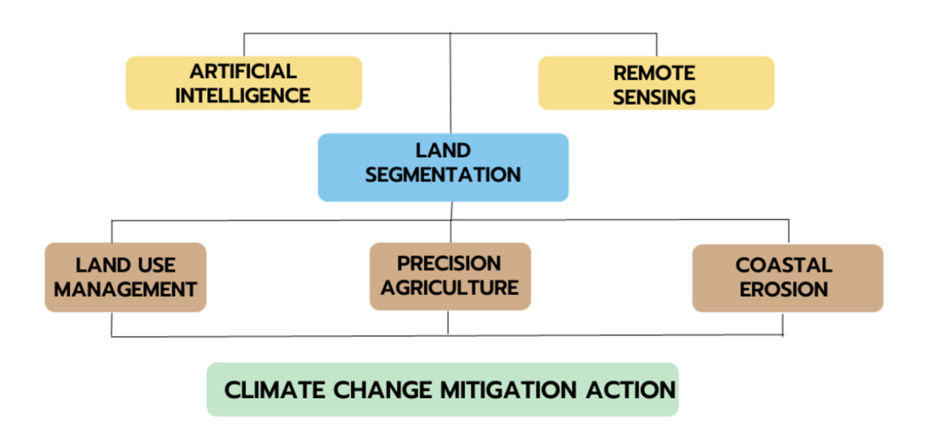
As our planet experiences unprecedented heat waves, ice melting, and a steady rise in average temperatures, the unmistakable impact of global climate change is apparent. This environmental crisis has been recognized as the "greatest global health threat of the twenty-first century,"urging the international community to take action. In response to this urgent call, nations worldwide have come together to address the challenges posed by climate change. The Paris Agreement and the Sustainable Development Goals are beacons of hope, signifying the collective commitment to a sustainable future. In this paper, we suggest land segmentation using deep learning to solve modeling and monitoring environmental phenomena as a way in which Artificial Intelligence could benefit the current efforts toward climate change mitigation endeavors. Using the DeepGlobe dataset, we suggest a deep learning-based method for land segmentation in this study to shed light on the impacts of climate change on land cover. We use the DeepGlobe dataset, which comprises high-resolution satellite images classified into several types of land cover. To execute pixel-level land segmentation and automatically extract complicated spatial information from the imagery, our suggested methodology utilizes a deep convolutional neural network architecture. By using the DeepGlobe dataset to train the model, we can take advantage of its broad coverage and variety of land cover classes, improving the model's capacity to generalize across multiple geographical regions. By monitoring and modeling the impacts of global climate change on agriculture, water resources depletion, and coastal erosion. We conclude that by allowing for more specialized and effcient land use management, conservation, and restoration measures, artificial intelligence can help in the fight against climate change.
Article Details

This work is licensed under a Creative Commons Attribution-NonCommercial-NoDerivatives 4.0 International License.
References
S. El Maachi, R. Saadane, M. Wahbi, A. Chehri and A. Badaoui, “Vision of IoT, 5G and 6G Data Processing: Applications in Climate Change Mitigation,” 2022 International Symposium on Intelligent Signal Processing and Communication Systems (ISPACS), Penang, Malaysia, pp. 1-6, 2022.
M. Mancini et al., “An Open Source and LowCost Internet of Things-enabled Service for Irrigation Management,” 2019 IEEE International Conference on Systems, Man and Cybernetics (SMC), Bari, Italy, pp. 1714-1719, 2019.
C. D. Butler, “Climate Change, Health and Existential Risks to Civilization: A Comprehensive Review (1989-2013),” International Journal of Environmental Research and Public Health, vol. 15, no. 10:2266, Oct. 2018.
Enayat A. Moallemi et al., “Achieving the Sustainable Development Goals Requires Transdisciplinary Innovation at the Local Scale,” One Earth 3, vol. 3, no. 2, pp. 300-313, Sep. 2020.
X. Zheng et al., “Consideration of Culture Is Vital If We Are to Achieve the Sustainable Development Goals,” One Earth, vol. 4, no. 2, pp. 307-319, Feb. 2021.
S. Fang et al., “An Integrated System for Regional Environmental Monitoring and Management Based on Internet of Things,” in IEEE Transactions on Industrial Informatics, vol. 10, no. 2, pp. 1596-1605, May 2014.
Food and Agriculture Organization of United Nations (FAO), “FAO. 2016. AQUASTAT Main Database.” [Online] Available: http://www.fao.org/nr/water/aquastat/data/query/index.html, accessed on 2019 March 28th.
H. V. Meijl et al., “Comparing impacts of climate change and mitigation on global agriculture by 2050,” Environmental Research Letters, vol. 13, no. 6:064021, 2018.
R. Girau et al., “Coastal Monitoring System Based on Social Internet of Things Platform,” in IEEE Internet of Things Journal, vol. 7, no. 2, pp. 1260-1272, Feb. 2020.
IPCC. (2018) Intergovernmental Panel On Climate Change, “Special Report: Global Warming of 1.5C,” [Online]. Available: https://www.ipcc.ch/sr15/
UNEP. (2019) United Nations Environment Programme, “Coordinating Unit for the Mediterranean Action Plan Secretariat to the Barcelona Convention and its Protocols,” [Online]. Available: http://web.unep.org/unepmap/
M. Mancini et al., “An Open Source and LowCost Internet of Things-enabled Service for Irrigation Management,” 2019 IEEE International Conference on Systems, Man and Cybernetics (SMC), Bari, Italy, pp. 1714-1719, 2019.
C. Kulatunga, L. Shalloo, W. Donnelly, E. Robson and S. Ivanov, “Opportunistic Wireless Networking for Smart Dairy Farming,” in IT Professional, vol. 19, no. 2, pp. 16-23, MarchApril 2017.
D. K. Fisher and P. J. Gould, “Open-Source Hardware Is a Low-Cost Alternative for Scientific InInstrumentation and Research,” Modern Instrumentation, vol. 1, n. 2, pp. 8-20, April 2012.
S. Seferbekov, V. Iglovikov, A. Buslaev and A.Shvets, “Feature Pyramid Network for Multiclass Land Segmentation,” 2018 IEEE/CVF Conference on Computer Vision and Pattern Recognition Workshops (CVPRW), Salt Lake City, UT, USA, pp. 272-2723, 2018.
K. Pichai, B. Park, A. Bao and Y. Yin, “Automated Segmentation and Classification of Aerial Forest Imagery,” Analytics, vol. 1, no.2, pp. 135143, 2022.
V. Pollatos, L. Kouvaras and E. Charou, “Land Cover Semantic Segmentation Using ResUNet,” arXiv preprint, 2020. [Online]. Available:https://doi.org/10.48550/arXiv.2010.06285
J. H. Kim et al., “Objects Segmentation From High-Resolution Aerial Images Using U-Net With Pyramid Pooling Layers,” inIEEE Geoscience and Remote Sensing Letters, vol. 16, no. 1, pp. 115–119, Jan. 2019.
B. C. Reed, J. F.Brown, D. VanderZee, T. R. Loveland, J. W. Merchant and D. O. Ohlen, “Measuring phenological variability from satellite imagery,” Journal of Vegetation Science, vol. 5, no. 5, pp. 703–714, 1994.
Y. Sawada, T. Koike, E. Ikoma and M. Kitsuregawa, “Monitoring and Predicting Agricultural Droughts for a Water-Limited Subcontinental Region by Integrating a Land Surface Model and Microwave Remote Sensing,” in IEEE Transactions on Geoscience and Remote Sensing, vol. 58, no. 1, pp. 14-33, Jan. 2020.
Global Soil Data Task Group, “Global Gridded Surfaces of Selected Soil Characteristics (IGBPDIS),” 2000. [Online]. Available:http://www.daac.ornl.gov/
D. Fernandez, F. Palazzo, A. Lipponen and S. Iris, “TIGER: Earth observation to improve African water resources management,” 2009 IEEE International Geoscience and Remote Sensing Symposium, Cape Town, South Africa, pp. I-248-I-251, 2009.
de Sherbinin, Alex Balk, Deborah Yager, Karina Jaiteh, Malanding Pozzi, Francesca Chandra, Giri Wannebo, Antoinette. (2023). A CIESIN Thematic Guide to Social Science Applications of Remote Sensing.
J. H. Kim et al., “Objects Segmentation From High-Resolution Aerial Images Using U-Net With Pyramid Pooling Layers,” in IEEE Geoscience and Remote Sensing Letters, vol. 16, no. 1, pp. 115-119, Jan. 2019.
O. Ronneberger, P. Fischer and T. Brox, “Unet: Convolutional networks for biomedical image segmentation,” in International Conference on Medical Image Computing and Computerassisted Intervention, pp. 234–241. Springer, 2015.
https://www.kaggle.com/datasets/balraj98/deepglobe-land-coverclassification-dataset
A. Tzepkenlis, K. Marthoglou and N. Grammalidis, “Efficient Deep Semantic Segmentation for Land Cover Classification Using Sentinel Imagery,” Remote Sensing, vol. 15, no.8:2027, 2023.
S. Puttinaovarat, P. Horkaew and K. Khaimook, “Conjuring ANN for inundation areas identification based on relevant thematic layers,” ECTI Transactions on Computer and Information Technology (ECTI-CIT), vol. 8, no. 1, pp. 56-66, 2014.
W. Boonpook et al., “Deep Learning Semantic Segmentation for Land Use and Land Cover Types Using Landsat 8 Imagery,” Internation Journal of Geo-Information (ISPRS), vol. 12, no.1:14, 2023.
